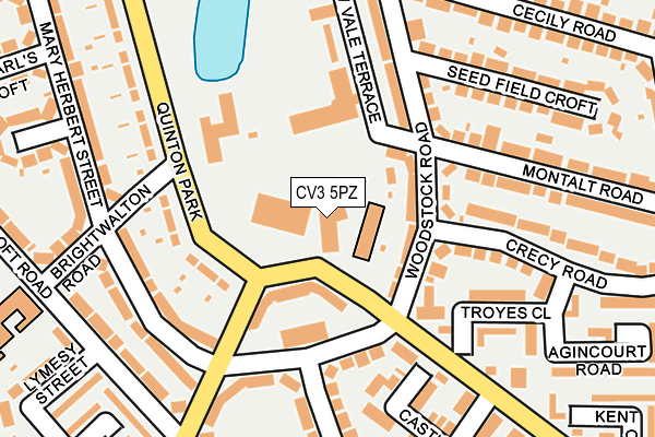
CV3 5PZ is located in the Cheylesmore electoral ward, within the metropolitan district of Coventry and the English Parliamentary constituency of Coventry South. The Sub Integrated Care Board (ICB) Location is NHS Coventry and Warwickshire ICB - B2M3M and the police force is West Midlands. This postcode has been in use since January 1980.


GetTheData
Source: OS OpenMap – Local (Ordnance Survey)
Source: OS VectorMap District (Ordnance Survey)
Licence: Open Government Licence (requires attribution)
| Easting | 433856 |
| Northing | 277149 |
| Latitude | 52.391324 |
| Longitude | -1.503924 |
GetTheData
Source: Open Postcode Geo
Licence: Open Government Licence
| Country | England |
| Postcode District | CV3 |
| ➜ CV3 open data dashboard ➜ See where CV3 is on a map ➜ Where is Coventry? | |
GetTheData
Source: Land Registry Price Paid Data
Licence: Open Government Licence
Elevation or altitude of CV3 5PZ as distance above sea level:
| Metres | Feet | |
|---|---|---|
| Elevation | 80m | 262ft |
Elevation is measured from the approximate centre of the postcode, to the nearest point on an OS contour line from OS Terrain 50, which has contour spacing of ten vertical metres.
➜ How high above sea level am I? Find the elevation of your current position using your device's GPS.
GetTheData
Source: Open Postcode Elevation
Licence: Open Government Licence
| Ward | Cheylesmore |
| Constituency | Coventry South |
GetTheData
Source: ONS Postcode Database
Licence: Open Government Licence
| December 2023 | Shoplifting | On or near Daventry Road | 318m |
| November 2023 | Violence and sexual offences | On or near Agincourt Road | 282m |
| November 2023 | Violence and sexual offences | On or near Agincourt Road | 282m |
| ➜ Get more crime data in our Crime section | |||
GetTheData
Source: data.police.uk
Licence: Open Government Licence
| Brightwalton Rd (Quinton Park) | Cheylesmore | 145m |
| Mary Herbert St (Black Prince Ave) | Cheylesmore | 154m |
| Brightwalton Rd (Quinton Park) | Cheylesmore | 169m |
| Mary Herbert St (Black Prince Ave) | Cheylesmore | 202m |
| Lymesy St (Ulverscroft Rd) | Cheylesmore | 232m |
| Coventry Station | 1.2km |
| Canley Station | 3.1km |
GetTheData
Source: NaPTAN
Licence: Open Government Licence
GetTheData
Source: ONS Postcode Database
Licence: Open Government Licence


➜ Get more ratings from the Food Standards Agency
GetTheData
Source: Food Standards Agency
Licence: FSA terms & conditions
| Last Collection | |||
|---|---|---|---|
| Location | Mon-Fri | Sat | Distance |
| Woodstock Road | 18:45 | 10:45 | 120m |
| Daventry Road Post Office | 19:00 | 11:15 | 330m |
| The Mount | 17:30 | 11:15 | 401m |
GetTheData
Source: Dracos
Licence: Creative Commons Attribution-ShareAlike
| Facility | Distance |
|---|---|
| Manor Park Primary School Ulverscroft Road, Coventry Grass Pitches | 337m |
| Howes Primary School Palermo Avenue, Coventry Grass Pitches | 649m |
| Whitley Common The Park Paling, Coventry Grass Pitches | 674m |
GetTheData
Source: Active Places
Licence: Open Government Licence
| School | Phase of Education | Distance |
|---|---|---|
| Manor Park Primary School Ulverscroft Road, Cheylesmore, Coventry, CV3 5EZ | Primary | 343m |
| Coventry Speech and Language Service Co Manor Park Primary School Ulverscroft Road, Cheylesmore, Coventry, CV3 5EZ | Not applicable | 346m |
| Howes Community Primary School Palermo Avenue, Cheylesmore, Coventry, CV3 5EH | Primary | 710m |
GetTheData
Source: Edubase
Licence: Open Government Licence
The below table lists the International Territorial Level (ITL) codes (formerly Nomenclature of Territorial Units for Statistics (NUTS) codes) and Local Administrative Units (LAU) codes for CV3 5PZ:
| ITL 1 Code | Name |
|---|---|
| TLG | West Midlands (England) |
| ITL 2 Code | Name |
| TLG3 | West Midlands |
| ITL 3 Code | Name |
| TLG33 | Coventry |
| LAU 1 Code | Name |
| E08000026 | Coventry |
GetTheData
Source: ONS Postcode Directory
Licence: Open Government Licence
The below table lists the Census Output Area (OA), Lower Layer Super Output Area (LSOA), and Middle Layer Super Output Area (MSOA) for CV3 5PZ:
| Code | Name | |
|---|---|---|
| OA | E00048347 | |
| LSOA | E01009552 | Coventry 037E |
| MSOA | E02001994 | Coventry 037 |
GetTheData
Source: ONS Postcode Directory
Licence: Open Government Licence
| CV3 5HZ | Quinton Park | 72m |
| CV3 5HP | Woodstock Road | 76m |
| CV3 5BH | The Chesils | 105m |
| CV3 5HY | Quinton Park | 130m |
| CV3 5HQ | Woodstock Road | 149m |
| CV3 5EX | Mary Herbert Street | 152m |
| CV3 5EW | Mary Herbert Street | 171m |
| CV3 5PU | Troyes Close | 180m |
| CV3 5HR | Crecy Road | 189m |
| CV3 5LU | Montalt Road | 207m |
GetTheData
Source: Open Postcode Geo; Land Registry Price Paid Data
Licence: Open Government Licence