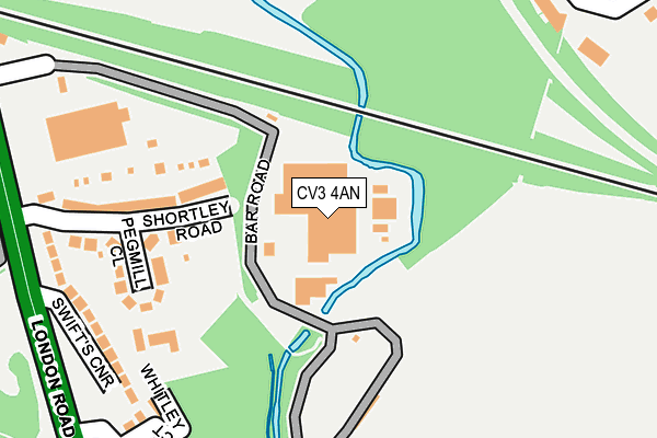
CV3 4AN is located in the Cheylesmore electoral ward, within the metropolitan district of Coventry and the English Parliamentary constituency of Coventry South. The Sub Integrated Care Board (ICB) Location is NHS Coventry and Warwickshire ICB - B2M3M and the police force is West Midlands. This postcode has been in use since January 1980.


GetTheData
Source: OS OpenMap – Local (Ordnance Survey)
Source: OS VectorMap District (Ordnance Survey)
Licence: Open Government Licence (requires attribution)
| Easting | 434701 |
| Northing | 277678 |
| Latitude | 52.396027 |
| Longitude | -1.491453 |
GetTheData
Source: Open Postcode Geo
Licence: Open Government Licence
| Country | England |
| Postcode District | CV3 |
➜ See where CV3 is on a map ➜ Where is Coventry? | |
GetTheData
Source: Land Registry Price Paid Data
Licence: Open Government Licence
Elevation or altitude of CV3 4AN as distance above sea level:
| Metres | Feet | |
|---|---|---|
| Elevation | 70m | 230ft |
Elevation is measured from the approximate centre of the postcode, to the nearest point on an OS contour line from OS Terrain 50, which has contour spacing of ten vertical metres.
➜ How high above sea level am I? Find the elevation of your current position using your device's GPS.
GetTheData
Source: Open Postcode Elevation
Licence: Open Government Licence
| Ward | Cheylesmore |
| Constituency | Coventry South |
GetTheData
Source: ONS Postcode Database
Licence: Open Government Licence
| Daventry Rd (London Rd) | Cheylesmore | 275m |
| Bar Rd (London Rd) | Cheylesmore | 304m |
| Daventry Rd (London Rd) | Cheylesmore | 354m |
| Bar Rd (London Rd) | Cheylesmore | 380m |
| London Rd (Daventry Rd) | Cheylesmore | 456m |
| Coventry Station | 1.6km |
| Canley Station | 3.8km |
GetTheData
Source: NaPTAN
Licence: Open Government Licence
GetTheData
Source: ONS Postcode Database
Licence: Open Government Licence


➜ Get more ratings from the Food Standards Agency
GetTheData
Source: Food Standards Agency
Licence: FSA terms & conditions
| Last Collection | |||
|---|---|---|---|
| Location | Mon-Fri | Sat | Distance |
| The Mount | 17:30 | 11:15 | 601m |
| Terry Road | 19:00 | 10:15 | 653m |
| Cornelius Street | 17:30 | 11:15 | 817m |
GetTheData
Source: Dracos
Licence: Creative Commons Attribution-ShareAlike
| Risk of CV3 4AN flooding from rivers and sea | Medium |
| ➜ CV3 4AN flood map | |
GetTheData
Source: Open Flood Risk by Postcode
Licence: Open Government Licence
The below table lists the International Territorial Level (ITL) codes (formerly Nomenclature of Territorial Units for Statistics (NUTS) codes) and Local Administrative Units (LAU) codes for CV3 4AN:
| ITL 1 Code | Name |
|---|---|
| TLG | West Midlands (England) |
| ITL 2 Code | Name |
| TLG3 | West Midlands |
| ITL 3 Code | Name |
| TLG33 | Coventry |
| LAU 1 Code | Name |
| E08000026 | Coventry |
GetTheData
Source: ONS Postcode Directory
Licence: Open Government Licence
The below table lists the Census Output Area (OA), Lower Layer Super Output Area (LSOA), and Middle Layer Super Output Area (MSOA) for CV3 4AN:
| Code | Name | |
|---|---|---|
| OA | E00048342 | |
| LSOA | E01009544 | Coventry 038A |
| MSOA | E02001995 | Coventry 038 |
GetTheData
Source: ONS Postcode Directory
Licence: Open Government Licence
| CV3 4AE | Shortley Road | 174m |
| CV3 4AF | Pegmill Close | 200m |
| CV3 4AG | Swifts Corner | 233m |
| CV3 4AH | Whitley Court | 247m |
| CV3 4AA | London Road | 256m |
| CV3 4AJ | Whitley Village | 320m |
| CV3 1BH | Humber Road | 352m |
| CV3 1NZ | Humber Road | 353m |
| CV3 1NS | Hussar Court | 396m |
| CV3 5PN | Calder Close | 408m |
GetTheData
Source: Open Postcode Geo; Land Registry Price Paid Data
Licence: Open Government Licence