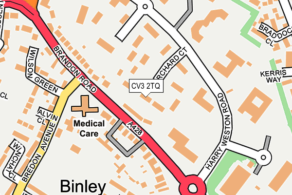
CV3 2TQ is located in the Wyken electoral ward, within the metropolitan district of Coventry and the English Parliamentary constituency of Coventry North East. The Sub Integrated Care Board (ICB) Location is NHS Coventry and Warwickshire ICB - B2M3M and the police force is West Midlands. This postcode has been in use since January 1993.


GetTheData
Source: OS OpenMap – Local (Ordnance Survey)
Source: OS VectorMap District (Ordnance Survey)
Licence: Open Government Licence (requires attribution)
| Easting | 437996 |
| Northing | 278227 |
| Latitude | 52.400744 |
| Longitude | -1.442969 |
GetTheData
Source: Open Postcode Geo
Licence: Open Government Licence
| Country | England |
| Postcode District | CV3 |
| ➜ CV3 open data dashboard ➜ See where CV3 is on a map ➜ Where is Coventry? | |
GetTheData
Source: Land Registry Price Paid Data
Licence: Open Government Licence
Elevation or altitude of CV3 2TQ as distance above sea level:
| Metres | Feet | |
|---|---|---|
| Elevation | 80m | 262ft |
Elevation is measured from the approximate centre of the postcode, to the nearest point on an OS contour line from OS Terrain 50, which has contour spacing of ten vertical metres.
➜ How high above sea level am I? Find the elevation of your current position using your device's GPS.
GetTheData
Source: Open Postcode Elevation
Licence: Open Government Licence
| Ward | Wyken |
| Constituency | Coventry North East |
GetTheData
Source: ONS Postcode Database
Licence: Open Government Licence
| July 2023 | Violence and sexual offences | On or near Hargrave Close | 390m |
| July 2023 | Violence and sexual offences | On or near Hargrave Close | 390m |
| April 2023 | Violence and sexual offences | On or near Hargrave Close | 390m |
| ➜ Get more crime data in our Crime section | |||
GetTheData
Source: data.police.uk
Licence: Open Government Licence
| Willenhall Lane (Brandon Rd) | Binley | 130m |
| Willenhall Lane (Brandon Rd) | Binley | 141m |
| Binley Park Inn (Brandon Rd) | Binley | 230m |
| Binley Park Inn (Brandon Rd) | Binley | 276m |
| Industrial Estate (Willenhall Lane) | Binley | 332m |
| Coventry Station | 4.8km |
GetTheData
Source: NaPTAN
Licence: Open Government Licence
Estimated total energy consumption in CV3 2TQ by fuel type, 2015.
| Consumption (kWh) | 588,076 |
|---|---|
| Meter count | 20 |
| Mean (kWh/meter) | 29,404 |
| Median (kWh/meter) | 18,867 |
GetTheData
Source: Postcode level gas estimates: 2015 (experimental)
Source: Postcode level electricity estimates: 2015 (experimental)
Licence: Open Government Licence
GetTheData
Source: ONS Postcode Database
Licence: Open Government Licence


➜ Get more ratings from the Food Standards Agency
GetTheData
Source: Food Standards Agency
Licence: FSA terms & conditions
| Last Collection | |||
|---|---|---|---|
| Location | Mon-Fri | Sat | Distance |
| Walsgrave Road Post Office | 18:00 | 12:00 | 602m |
| Herald Way | 18:30 | 10:15 | 845m |
| Mayflower Drive | 16:30 | 10:45 | 1,052m |
GetTheData
Source: Dracos
Licence: Creative Commons Attribution-ShareAlike
| Facility | Distance |
|---|---|
| Coventry Saracens Rugby Club Bredon Avenue, Binley, Coventry Grass Pitches | 180m |
| Fitness Factory Santos Close, Binley, Coventry Health and Fitness Gym | 473m |
| Ernesford Grange Primary School Foxton Road, Binley, Coventry Grass Pitches | 682m |
GetTheData
Source: Active Places
Licence: Open Government Licence
| School | Phase of Education | Distance |
|---|---|---|
| Ernesford Grange Primary School Foxton Road, Binley, Coventry, CV3 2HN | Primary | 701m |
| Clifford Bridge Academy Coombe Park Road, Binley, Coventry, CV3 2PD | Primary | 846m |
| St Bartholomew's Church of England Academy Bredon Avenue, Binley, Coventry, CV3 2LP | Primary | 881m |
GetTheData
Source: Edubase
Licence: Open Government Licence
The below table lists the International Territorial Level (ITL) codes (formerly Nomenclature of Territorial Units for Statistics (NUTS) codes) and Local Administrative Units (LAU) codes for CV3 2TQ:
| ITL 1 Code | Name |
|---|---|
| TLG | West Midlands (England) |
| ITL 2 Code | Name |
| TLG3 | West Midlands |
| ITL 3 Code | Name |
| TLG33 | Coventry |
| LAU 1 Code | Name |
| E08000026 | Coventry |
GetTheData
Source: ONS Postcode Directory
Licence: Open Government Licence
The below table lists the Census Output Area (OA), Lower Layer Super Output Area (LSOA), and Middle Layer Super Output Area (MSOA) for CV3 2TQ:
| Code | Name | |
|---|---|---|
| OA | E00048265 | |
| LSOA | E01009532 | Coventry 033A |
| MSOA | E02001990 | Coventry 033 |
GetTheData
Source: ONS Postcode Directory
Licence: Open Government Licence
| CV3 2JF | Brandon Road | 100m |
| CV3 2JD | Brandon Road | 138m |
| CV3 2JE | Brandon Road | 178m |
| CV3 2TG | Wilson Green | 202m |
| CV3 2ES | Falcon Avenue | 247m |
| CV3 2JY | Alvin Close | 253m |
| CV3 2FD | Bredon Avenue | 261m |
| CV3 2TN | Wilson Green | 264m |
| CV3 2FB | Ibex Close | 286m |
| CV3 2XW | Braddock Close | 302m |
GetTheData
Source: Open Postcode Geo; Land Registry Price Paid Data
Licence: Open Government Licence