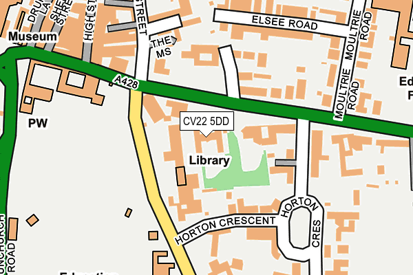
CV22 5DD is located in the Eastlands electoral ward, within the local authority district of Rugby and the English Parliamentary constituency of Rugby. The Sub Integrated Care Board (ICB) Location is NHS Coventry and Warwickshire ICB - B2M3M and the police force is Warwickshire. This postcode has been in use since January 1980.


GetTheData
Source: OS OpenMap – Local (Ordnance Survey)
Source: OS VectorMap District (Ordnance Survey)
Licence: Open Government Licence (requires attribution)
| Easting | 450475 |
| Northing | 274903 |
| Latitude | 52.369874 |
| Longitude | -1.260058 |
GetTheData
Source: Open Postcode Geo
Licence: Open Government Licence
| Country | England |
| Postcode District | CV22 |
| ➜ CV22 open data dashboard ➜ See where CV22 is on a map ➜ Where is Rugby? | |
GetTheData
Source: Land Registry Price Paid Data
Licence: Open Government Licence
Elevation or altitude of CV22 5DD as distance above sea level:
| Metres | Feet | |
|---|---|---|
| Elevation | 110m | 361ft |
Elevation is measured from the approximate centre of the postcode, to the nearest point on an OS contour line from OS Terrain 50, which has contour spacing of ten vertical metres.
➜ How high above sea level am I? Find the elevation of your current position using your device's GPS.
GetTheData
Source: Open Postcode Elevation
Licence: Open Government Licence
| Ward | Eastlands |
| Constituency | Rugby |
GetTheData
Source: ONS Postcode Database
Licence: Open Government Licence
| January 2024 | Criminal damage and arson | On or near Gas Street | 339m |
| December 2023 | Drugs | On or near Gas Street | 339m |
| December 2023 | Drugs | On or near Gas Street | 339m |
| ➜ Get more crime data in our Crime section | |||
GetTheData
Source: data.police.uk
Licence: Open Government Licence
| Lawrence Sheriff Street (Barby Road) | Rugby | 118m |
| Lawrence Sheriff Street (Barby Road) | Rugby | 133m |
| Clifton Road | Rugby | 283m |
| Clifton Road | Rugby | 323m |
| Clifton Road (Railway Terrace) | Rugby | 324m |
| Rugby Station | 1.2km |
GetTheData
Source: NaPTAN
Licence: Open Government Licence
| Percentage of properties with Next Generation Access | 100.0% |
| Percentage of properties with Superfast Broadband | 100.0% |
| Percentage of properties with Ultrafast Broadband | 0.0% |
| Percentage of properties with Full Fibre Broadband | 0.0% |
Superfast Broadband is between 30Mbps and 300Mbps
Ultrafast Broadband is > 300Mbps
| Percentage of properties unable to receive 2Mbps | 0.0% |
| Percentage of properties unable to receive 5Mbps | 0.0% |
| Percentage of properties unable to receive 10Mbps | 0.0% |
| Percentage of properties unable to receive 30Mbps | 0.0% |
GetTheData
Source: Ofcom
Licence: Ofcom Terms of Use (requires attribution)
GetTheData
Source: ONS Postcode Database
Licence: Open Government Licence


➜ Get more ratings from the Food Standards Agency
GetTheData
Source: Food Standards Agency
Licence: FSA terms & conditions
| Last Collection | |||
|---|---|---|---|
| Location | Mon-Fri | Sat | Distance |
| Horton Crescent | 16:00 | 11:15 | 115m |
| Rugby School | 16:00 | 11:45 | 187m |
| Sheep Street | 18:30 | 11:45 | 267m |
GetTheData
Source: Dracos
Licence: Creative Commons Attribution-ShareAlike
| Facility | Distance |
|---|---|
| Rugby School Playing Fields Barby Road, Rugby Grass Pitches | 273m |
| Bishop Wulstan Catholic School (Closed) Oak Street, Rugby Sports Hall | 317m |
| 336m |
GetTheData
Source: Active Places
Licence: Open Government Licence
| School | Phase of Education | Distance |
|---|---|---|
| Rugby School The Bursary, 10 Little Church Street, Rugby, CV21 3AW | Not applicable | 222m |
| Lawrence Sheriff School Clifton Road, Rugby, CV21 3AG | Secondary | 371m |
| St Marie's Catholic Primary School Merttens Drive, Rugby, CV22 7AF | Primary | 615m |
GetTheData
Source: Edubase
Licence: Open Government Licence
The below table lists the International Territorial Level (ITL) codes (formerly Nomenclature of Territorial Units for Statistics (NUTS) codes) and Local Administrative Units (LAU) codes for CV22 5DD:
| ITL 1 Code | Name |
|---|---|
| TLG | West Midlands (England) |
| ITL 2 Code | Name |
| TLG1 | Herefordshire, Worcestershire and Warwickshire |
| ITL 3 Code | Name |
| TLG13 | Warwickshire CC |
| LAU 1 Code | Name |
| E07000220 | Rugby |
GetTheData
Source: ONS Postcode Directory
Licence: Open Government Licence
The below table lists the Census Output Area (OA), Lower Layer Super Output Area (LSOA), and Middle Layer Super Output Area (MSOA) for CV22 5DD:
| Code | Name | |
|---|---|---|
| OA | E00168337 | |
| LSOA | E01031145 | Rugby 009C |
| MSOA | E02006500 | Rugby 009 |
GetTheData
Source: ONS Postcode Directory
Licence: Open Government Licence
| CV22 5DF | Hillmorton Road | 80m |
| CV21 3AY | Church Walk | 83m |
| CV21 3AX | Arnold Villas | 123m |
| CV21 3AT | Eastfield Place | 180m |
| CV21 3BA | Elsee Road | 184m |
| CV22 5EJ | Lawrence Sheriff Street | 233m |
| CV21 3BH | Windsor Court | 235m |
| CV21 3AW | Little Church Street | 241m |
| CV21 3BD | Moultrie Road | 246m |
| CV21 3BG | High Street | 248m |
GetTheData
Source: Open Postcode Geo; Land Registry Price Paid Data
Licence: Open Government Licence