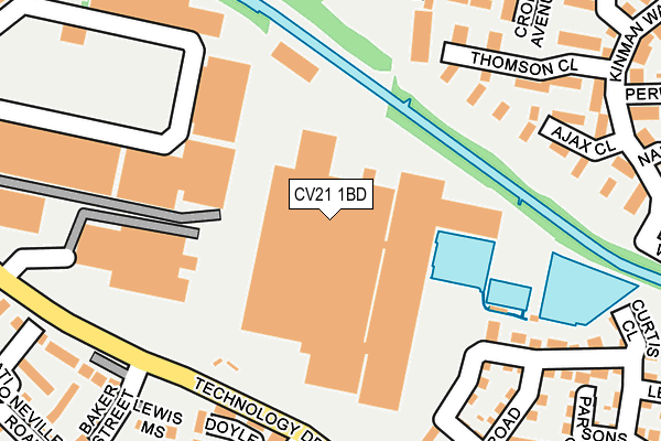
CV21 1BD is located in the Newbold and Brownsover electoral ward, within the local authority district of Rugby and the English Parliamentary constituency of Rugby. The Sub Integrated Care Board (ICB) Location is NHS Coventry and Warwickshire ICB - B2M3M and the police force is Warwickshire. This postcode has been in use since November 2015.


GetTheData
Source: OS OpenMap – Local (Ordnance Survey)
Source: OS VectorMap District (Ordnance Survey)
Licence: Open Government Licence (requires attribution)
| Easting | 450792 |
| Northing | 276532 |
| Latitude | 52.384472 |
| Longitude | -1.255168 |
GetTheData
Source: Open Postcode Geo
Licence: Open Government Licence
| Country | England |
| Postcode District | CV21 |
➜ See where CV21 is on a map ➜ Where is Rugby? | |
GetTheData
Source: Land Registry Price Paid Data
Licence: Open Government Licence
Elevation or altitude of CV21 1BD as distance above sea level:
| Metres | Feet | |
|---|---|---|
| Elevation | 90m | 295ft |
Elevation is measured from the approximate centre of the postcode, to the nearest point on an OS contour line from OS Terrain 50, which has contour spacing of ten vertical metres.
➜ How high above sea level am I? Find the elevation of your current position using your device's GPS.
GetTheData
Source: Open Postcode Elevation
Licence: Open Government Licence
| Ward | Newbold And Brownsover |
| Constituency | Rugby |
GetTheData
Source: ONS Postcode Database
Licence: Open Government Licence
| Platform 1 (Technology Park) | Rugby | 344m |
| Platform 1 (Technology Drive) | Rugby | 353m |
| Tesco (Private Road) | Rugby | 353m |
| Houston Road (Boughton Road) | Rugby | 391m |
| Douglas Road (Boughton Road) | Rugby | 423m |
| Rugby Station | 0.7km |
GetTheData
Source: NaPTAN
Licence: Open Government Licence
GetTheData
Source: ONS Postcode Database
Licence: Open Government Licence

➜ Get more ratings from the Food Standards Agency
GetTheData
Source: Food Standards Agency
Licence: FSA terms & conditions
| Last Collection | |||
|---|---|---|---|
| Location | Mon-Fri | Sat | Distance |
| Tesco Supermarket | 17:30 | 11:45 | 362m |
| Boughton Road Post Office | 17:30 | 12:00 | 425m |
| Mill Road Delivery Office | 18:30 | 12:00 | 619m |
GetTheData
Source: Dracos
Licence: Creative Commons Attribution-ShareAlike
| Risk of CV21 1BD flooding from rivers and sea | Low |
| ➜ CV21 1BD flood map | |
GetTheData
Source: Open Flood Risk by Postcode
Licence: Open Government Licence
The below table lists the International Territorial Level (ITL) codes (formerly Nomenclature of Territorial Units for Statistics (NUTS) codes) and Local Administrative Units (LAU) codes for CV21 1BD:
| ITL 1 Code | Name |
|---|---|
| TLG | West Midlands (England) |
| ITL 2 Code | Name |
| TLG1 | Herefordshire, Worcestershire and Warwickshire |
| ITL 3 Code | Name |
| TLG13 | Warwickshire CC |
| LAU 1 Code | Name |
| E07000220 | Rugby |
GetTheData
Source: ONS Postcode Directory
Licence: Open Government Licence
The below table lists the Census Output Area (OA), Lower Layer Super Output Area (LSOA), and Middle Layer Super Output Area (MSOA) for CV21 1BD:
| Code | Name | |
|---|---|---|
| OA | E00158731 | |
| LSOA | E01031141 | Rugby 002E |
| MSOA | E02006493 | Rugby 002 |
GetTheData
Source: ONS Postcode Directory
Licence: Open Government Licence
| CV21 1XJ | Thomson Close | 197m |
| CV21 1GF | Glebe Farm Road | 215m |
| CV21 1XH | Ajax Close | 220m |
| CV21 1AQ | Thruxton Place | 237m |
| CV21 1FF | Edison Drive | 245m |
| CV21 1GH | Tainter Close | 249m |
| CV21 1GL | Tainter Close | 267m |
| CV21 1AD | Croft Avenue | 270m |
| CV21 1FH | Curtis Close | 287m |
| CV21 1GR | Thomas Road | 291m |
GetTheData
Source: Open Postcode Geo; Land Registry Price Paid Data
Licence: Open Government Licence