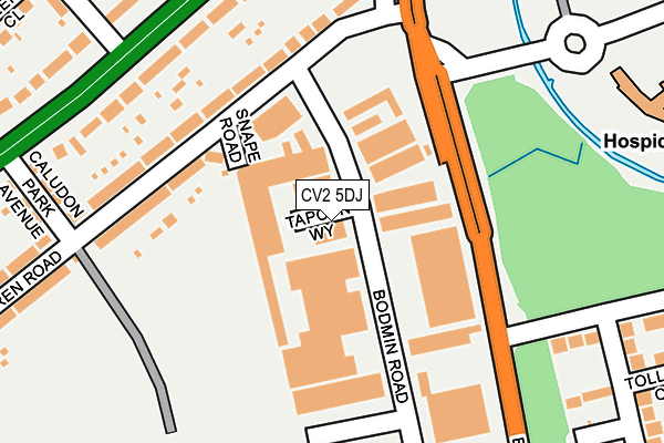
CV2 5DJ is located in the Wyken electoral ward, within the metropolitan district of Coventry and the English Parliamentary constituency of Coventry North East. The Sub Integrated Care Board (ICB) Location is NHS Coventry and Warwickshire ICB - B2M3M and the police force is West Midlands. This postcode has been in use since December 2005.


GetTheData
Source: OS OpenMap – Local (Ordnance Survey)
Source: OS VectorMap District (Ordnance Survey)
Licence: Open Government Licence (requires attribution)
| Easting | 437599 |
| Northing | 280326 |
| Latitude | 52.419640 |
| Longitude | -1.448569 |
GetTheData
Source: Open Postcode Geo
Licence: Open Government Licence
| Country | England |
| Postcode District | CV2 |
| ➜ CV2 open data dashboard ➜ See where CV2 is on a map ➜ Where is Coventry? | |
GetTheData
Source: Land Registry Price Paid Data
Licence: Open Government Licence
Elevation or altitude of CV2 5DJ as distance above sea level:
| Metres | Feet | |
|---|---|---|
| Elevation | 80m | 262ft |
Elevation is measured from the approximate centre of the postcode, to the nearest point on an OS contour line from OS Terrain 50, which has contour spacing of ten vertical metres.
➜ How high above sea level am I? Find the elevation of your current position using your device's GPS.
GetTheData
Source: Open Postcode Elevation
Licence: Open Government Licence
| Ward | Wyken |
| Constituency | Coventry North East |
GetTheData
Source: ONS Postcode Database
Licence: Open Government Licence
| January 2024 | Violence and sexual offences | On or near Norton Hill Drive | 440m |
| October 2023 | Violence and sexual offences | On or near Norton Hill Drive | 440m |
| September 2023 | Anti-social behaviour | On or near Norton Hill Drive | 440m |
| ➜ Get more crime data in our Crime section | |||
GetTheData
Source: data.police.uk
Licence: Open Government Licence
| Dorchester Way (Clifford Bridge Rd) | Wyken Green | 143m |
| Walsgrave Hospital Temp Stop (University Hospital) | Wyken Green | 215m |
| Norton Hill Drive (Ansty Rd) | Wyken Green | 247m |
| Clifford Bridge Rd (Ansty Rd) | Wyken Green | 261m |
| Clifford Bridge Rd (Ansty Rd) | Wyken Green | 283m |
| Coventry Arena Station | 4.4km |
| Coventry Station | 4.9km |
GetTheData
Source: NaPTAN
Licence: Open Government Licence
GetTheData
Source: ONS Postcode Database
Licence: Open Government Licence


➜ Get more ratings from the Food Standards Agency
GetTheData
Source: Food Standards Agency
Licence: FSA terms & conditions
| Last Collection | |||
|---|---|---|---|
| Location | Mon-Fri | Sat | Distance |
| Schollhouse Lane | 17:00 | 09:45 | 604m |
| Walsgrave Hospital Main | 17:30 | 10:15 | 773m |
| Athol Road | 17:00 | 09:45 | 791m |
GetTheData
Source: Dracos
Licence: Creative Commons Attribution-ShareAlike
| Facility | Distance |
|---|---|
| Wyken Extended Learning Centre Axholme Road, Coventry Grass Pitches | 550m |
| Caludon Castle Sports Centre Axholme Road, Coventry Sports Hall, Swimming Pool, Health and Fitness Gym, Artificial Grass Pitch, Grass Pitches, Studio, Outdoor Tennis Courts | 650m |
| Pearl Hyde Primary School Dorchester Way, Coventry Grass Pitches | 663m |
GetTheData
Source: Active Places
Licence: Open Government Licence
| School | Phase of Education | Distance |
|---|---|---|
| Wyken Croft Primary School Wyken Croft, Wyken, Coventry, CV2 3AA | Primary | 477m |
| Coventry Extended Learning Centre Axholme Road, Wyken, Coventry, CV2 5BD | Not applicable | 614m |
| Pearl Hyde Community Primary School Dorchester Way, Clifford Park, Coventry, CV2 2NB | Primary | 618m |
GetTheData
Source: Edubase
Licence: Open Government Licence
The below table lists the International Territorial Level (ITL) codes (formerly Nomenclature of Territorial Units for Statistics (NUTS) codes) and Local Administrative Units (LAU) codes for CV2 5DJ:
| ITL 1 Code | Name |
|---|---|
| TLG | West Midlands (England) |
| ITL 2 Code | Name |
| TLG3 | West Midlands |
| ITL 3 Code | Name |
| TLG33 | Coventry |
| LAU 1 Code | Name |
| E08000026 | Coventry |
GetTheData
Source: ONS Postcode Directory
Licence: Open Government Licence
The below table lists the Census Output Area (OA), Lower Layer Super Output Area (LSOA), and Middle Layer Super Output Area (MSOA) for CV2 5DJ:
| Code | Name | |
|---|---|---|
| OA | E00049124 | |
| LSOA | E01009713 | Coventry 019B |
| MSOA | E02001976 | Coventry 019 |
GetTheData
Source: ONS Postcode Directory
Licence: Open Government Licence
| CV2 5ED | Snape Road | 119m |
| CV2 5EE | Farren Road | 161m |
| CV2 5EF | Farren Road | 163m |
| CV2 5DA | Farren Road | 183m |
| CV2 3FF | Ansty Road | 217m |
| CV2 3FE | Ansty Road | 231m |
| CV2 5BZ | Clifford Bridge Road | 236m |
| CV2 2LB | Dorchester Way | 247m |
| CV2 5EG | Caludon Park Avenue | 274m |
| CV2 3BQ | Ansty Road | 293m |
GetTheData
Source: Open Postcode Geo; Land Registry Price Paid Data
Licence: Open Government Licence