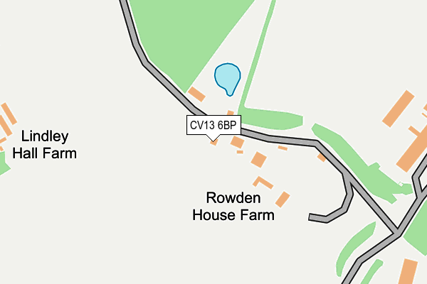
CV13 6BP is in Lindley, Nuneaton. CV13 6BP is located in the Ambien electoral ward, within the local authority district of Hinckley and Bosworth and the English Parliamentary constituency of Bosworth. The Sub Integrated Care Board (ICB) Location is NHS Leicester, Leicestershire and Rutland ICB - 04V and the police force is Leicestershire. This postcode has been in use since January 1980.


GetTheData
Source: OS OpenMap – Local (Ordnance Survey)
Source: OS VectorMap District (Ordnance Survey)
Licence: Open Government Licence (requires attribution)
| Easting | 436548 |
| Northing | 296429 |
| Latitude | 52.564470 |
| Longitude | -1.462260 |
GetTheData
Source: Open Postcode Geo
Licence: Open Government Licence
| Locality | Lindley |
| Town/City | Nuneaton |
| Country | England |
| Postcode District | CV13 |
| ➜ CV13 open data dashboard ➜ See where CV13 is on a map | |
GetTheData
Source: Land Registry Price Paid Data
Licence: Open Government Licence
Elevation or altitude of CV13 6BP as distance above sea level:
| Metres | Feet | |
|---|---|---|
| Elevation | 100m | 328ft |
Elevation is measured from the approximate centre of the postcode, to the nearest point on an OS contour line from OS Terrain 50, which has contour spacing of ten vertical metres.
➜ How high above sea level am I? Find the elevation of your current position using your device's GPS.
GetTheData
Source: Open Postcode Elevation
Licence: Open Government Licence
| Ward | Ambien |
| Constituency | Bosworth |
GetTheData
Source: ONS Postcode Database
Licence: Open Government Licence
| Mira (Mira Drive) | Higham-on-the-hill | 1,198m |
| Hunters Lane (George Fox Lane) | Fenny Drayton | 1,496m |
| Quaker Close (Old Forge Road) | Fenny Drayton | 1,550m |
| Quaker Close (Old Forge Road) | Fenny Drayton | 1,562m |
| Turn (Weddington Lane) | Caldecote | 1,722m |
| Nuneaton Station | 4.2km |
GetTheData
Source: NaPTAN
Licence: Open Government Licence
| Percentage of properties with Next Generation Access | 100.0% |
| Percentage of properties with Superfast Broadband | 0.0% |
| Percentage of properties with Ultrafast Broadband | 0.0% |
| Percentage of properties with Full Fibre Broadband | 0.0% |
Superfast Broadband is between 30Mbps and 300Mbps
Ultrafast Broadband is > 300Mbps
| Percentage of properties unable to receive 2Mbps | 40.0% |
| Percentage of properties unable to receive 5Mbps | 40.0% |
| Percentage of properties unable to receive 10Mbps | 40.0% |
| Percentage of properties unable to receive 30Mbps | 100.0% |
GetTheData
Source: Ofcom
Licence: Ofcom Terms of Use (requires attribution)
GetTheData
Source: ONS Postcode Database
Licence: Open Government Licence


➜ Get more ratings from the Food Standards Agency
GetTheData
Source: Food Standards Agency
Licence: FSA terms & conditions
| Last Collection | |||
|---|---|---|---|
| Location | Mon-Fri | Sat | Distance |
| Fenny Drayton Post Office | 16:45 | 09:45 | 1,568m |
| Higham On The Hill P.o. | 17:15 | 10:30 | 1,813m |
| Watling Street | 16:00 | 09:15 | 2,650m |
GetTheData
Source: Dracos
Licence: Creative Commons Attribution-ShareAlike
| Facility | Distance |
|---|---|
| Mira Technology Park Mira Drive, Watling Street, Lindley, Nuneaton Grass Pitches, Outdoor Tennis Courts | 1km |
| Higham On The Hill Recreation Ground Main Street, Higham-on-the-hill, Nuneaton Grass Pitches | 1.6km |
| Kings Lodge Watling Street, Nuneaton Grass Pitches | 2km |
GetTheData
Source: Active Places
Licence: Open Government Licence
| School | Phase of Education | Distance |
|---|---|---|
| Higham-on-the-Hill Church of England Primary School Main Street, Higham-on-the-Hill, Nuneaton, CV13 6AJ | Primary | 2km |
| Lower Farm Academy Milking Lane, Nuneaton, CV10 0FG | Primary | 2.3km |
| Milby Primary School Milby Drive, Nuneaton, CV11 6JS | Primary | 2.7km |
GetTheData
Source: Edubase
Licence: Open Government Licence
The below table lists the International Territorial Level (ITL) codes (formerly Nomenclature of Territorial Units for Statistics (NUTS) codes) and Local Administrative Units (LAU) codes for CV13 6BP:
| ITL 1 Code | Name |
|---|---|
| TLF | East Midlands (England) |
| ITL 2 Code | Name |
| TLF2 | Leicestershire, Rutland and Northamptonshire |
| ITL 3 Code | Name |
| TLF22 | Leicestershire CC and Rutland |
| LAU 1 Code | Name |
| E07000132 | Hinckley and Bosworth |
GetTheData
Source: ONS Postcode Directory
Licence: Open Government Licence
The below table lists the Census Output Area (OA), Lower Layer Super Output Area (LSOA), and Middle Layer Super Output Area (MSOA) for CV13 6BP:
| Code | Name | |
|---|---|---|
| OA | E00131003 | |
| LSOA | E01025818 | Hinckley and Bosworth 008B |
| MSOA | E02005384 | Hinckley and Bosworth 008 |
GetTheData
Source: ONS Postcode Directory
Licence: Open Government Licence
| CV10 0TT | Watling Street | 1081m |
| CV13 6BJ | Fenn Lane | 1136m |
| CV13 6AA | Wood Lane | 1430m |
| CV13 6BU | Hunters Lane | 1441m |
| CV13 6BX | Farriers Gate | 1477m |
| CV13 6AG | Station Road | 1477m |
| CV13 6BE | George Fox Lane | 1484m |
| CV13 6BS | Quaker Close | 1488m |
| CV13 6BG | Foxs Covert | 1535m |
| CV13 6BD | Old Forge Road | 1538m |
GetTheData
Source: Open Postcode Geo; Land Registry Price Paid Data
Licence: Open Government Licence