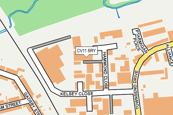
CV11 6RY is located in the Whitestone electoral ward, within the local authority district of Nuneaton and Bedworth and the English Parliamentary constituency of Nuneaton. The Sub Integrated Care Board (ICB) Location is NHS Coventry and Warwickshire ICB - B2M3M and the police force is Warwickshire. This postcode has been in use since August 1992.


GetTheData
Source: OS OpenMap – Local (Ordnance Survey)
Source: OS VectorMap District (Ordnance Survey)
Licence: Open Government Licence (requires attribution)
| Easting | 437380 |
| Northing | 291333 |
| Latitude | 52.518621 |
| Longitude | -1.450550 |
GetTheData
Source: Open Postcode Geo
Licence: Open Government Licence
| Country | England |
| Postcode District | CV11 |
| ➜ CV11 open data dashboard ➜ See where CV11 is on a map ➜ Where is Nuneaton? | |
GetTheData
Source: Land Registry Price Paid Data
Licence: Open Government Licence
Elevation or altitude of CV11 6RY as distance above sea level:
| Metres | Feet | |
|---|---|---|
| Elevation | 90m | 295ft |
Elevation is measured from the approximate centre of the postcode, to the nearest point on an OS contour line from OS Terrain 50, which has contour spacing of ten vertical metres.
➜ How high above sea level am I? Find the elevation of your current position using your device's GPS.
GetTheData
Source: Open Postcode Elevation
Licence: Open Government Licence
| Ward | Whitestone |
| Constituency | Nuneaton |
GetTheData
Source: ONS Postcode Database
Licence: Open Government Licence
| June 2022 | Shoplifting | On or near Ptarmigan Place | 222m |
| June 2022 | Criminal damage and arson | On or near William Street | 313m |
| June 2022 | Anti-social behaviour | On or near William Street | 313m |
| ➜ Get more crime data in our Crime section | |||
GetTheData
Source: data.police.uk
Licence: Open Government Licence
| Kelsey Close (Townsend Drive) | Attleborough | 174m |
| Kelsey Close (Townsend Drive) | Attleborough | 185m |
| Veasey Close (Townsend Drive) | Attleborough | 366m |
| Liberty Way (Townsend Drive) | Attleborough | 381m |
| Liberty Way (Townsend Drive) | Attleborough | 385m |
| Nuneaton Station | 1.3km |
| Bermuda Park Station | 2.4km |
| Bedworth Station | 4.5km |
GetTheData
Source: NaPTAN
Licence: Open Government Licence
| Median download speed | 4.2Mbps |
| Average download speed | 4.3Mbps |
| Maximum download speed | 6.91Mbps |
| Median upload speed | 0.9Mbps |
| Average upload speed | 0.9Mbps |
| Maximum upload speed | 1.11Mbps |
GetTheData
Source: Ofcom
Licence: Ofcom Terms of Use (requires attribution)
Estimated total energy consumption in CV11 6RY by fuel type, 2015.
| Consumption (kWh) | 122,661 |
|---|---|
| Meter count | 8 |
| Mean (kWh/meter) | 15,333 |
| Median (kWh/meter) | 15,258 |
GetTheData
Source: Postcode level gas estimates: 2015 (experimental)
Source: Postcode level electricity estimates: 2015 (experimental)
Licence: Open Government Licence
GetTheData
Source: ONS Postcode Database
Licence: Open Government Licence


➜ Get more ratings from the Food Standards Agency
GetTheData
Source: Food Standards Agency
Licence: FSA terms & conditions
| Last Collection | |||
|---|---|---|---|
| Location | Mon-Fri | Sat | Distance |
| Br Trent Valley Station | 17:30 | 11:45 | 1,211m |
| Stockingford Post Office | 17:00 | 12:00 | 1,227m |
| Coventry Street | 17:30 | 11:45 | 1,234m |
GetTheData
Source: Dracos
Licence: Creative Commons Attribution-ShareAlike
| Facility | Distance |
|---|---|
| Bettabodies Fitness Ltd (Closed) Liberty Way, Attleborough Fields Ind Estate, Nuneaton Health and Fitness Gym, Studio | 455m |
| Focus Fitness (Closed) Liberty Way, Attleborough Fields Ind Estate, Nuneaton Health and Fitness Gym, Studio | 470m |
| Nuneaton Rfc Liberty Way, Attleborough Fields Ind Estate, Nuneaton Grass Pitches | 537m |
GetTheData
Source: Active Places
Licence: Open Government Licence
| School | Phase of Education | Distance |
|---|---|---|
| ALP Nuneaton Holman Way, Nuneaton, CV11 4PN | Not applicable | 575m |
| King Edward VI College King Edward Road, Nuneaton, CV11 4BE | 16 plus | 851m |
| Etone College Leicester Road, Nuneaton, CV11 6AA | Secondary | 983m |
GetTheData
Source: Edubase
Licence: Open Government Licence
The below table lists the International Territorial Level (ITL) codes (formerly Nomenclature of Territorial Units for Statistics (NUTS) codes) and Local Administrative Units (LAU) codes for CV11 6RY:
| ITL 1 Code | Name |
|---|---|
| TLG | West Midlands (England) |
| ITL 2 Code | Name |
| TLG1 | Herefordshire, Worcestershire and Warwickshire |
| ITL 3 Code | Name |
| TLG13 | Warwickshire CC |
| LAU 1 Code | Name |
| E07000219 | Nuneaton and Bedworth |
GetTheData
Source: ONS Postcode Directory
Licence: Open Government Licence
The below table lists the Census Output Area (OA), Lower Layer Super Output Area (LSOA), and Middle Layer Super Output Area (MSOA) for CV11 6RY:
| Code | Name | |
|---|---|---|
| OA | E00158644 | |
| LSOA | E01031120 | Nuneaton and Bedworth 011A |
| MSOA | E02006485 | Nuneaton and Bedworth 011 |
GetTheData
Source: ONS Postcode Directory
Licence: Open Government Licence
| CV11 6RS | Kelsey Close | 150m |
| CV11 6GX | Watling Court | 173m |
| CV11 6RX | Ptarmigan Place | 238m |
| CV11 6SD | Alliance Close | 272m |
| CV11 4NZ | Gadsby Street | 273m |
| CV11 4PD | Gadsby Street | 281m |
| CV11 6RU | Townsend Drive | 289m |
| CV11 4PE | Gadsby Street | 316m |
| CV11 4PB | William Street | 319m |
| CV11 6RT | Veasey Close | 326m |
GetTheData
Source: Open Postcode Geo; Land Registry Price Paid Data
Licence: Open Government Licence