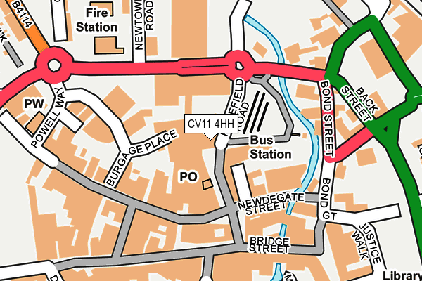
CV11 4HH is located in the Abbey electoral ward, within the local authority district of Nuneaton and Bedworth and the English Parliamentary constituency of Nuneaton. The Sub Integrated Care Board (ICB) Location is NHS Coventry and Warwickshire ICB - B2M3M and the police force is Warwickshire. This postcode has been in use since January 1980.


GetTheData
Source: OS OpenMap – Local (Ordnance Survey)
Source: OS VectorMap District (Ordnance Survey)
Licence: Open Government Licence (requires attribution)
| Easting | 436224 |
| Northing | 291943 |
| Latitude | 52.524182 |
| Longitude | -1.467519 |
GetTheData
Source: Open Postcode Geo
Licence: Open Government Licence
| Country | England |
| Postcode District | CV11 |
➜ See where CV11 is on a map ➜ Where is Nuneaton? | |
GetTheData
Source: Land Registry Price Paid Data
Licence: Open Government Licence
Elevation or altitude of CV11 4HH as distance above sea level:
| Metres | Feet | |
|---|---|---|
| Elevation | 80m | 262ft |
Elevation is measured from the approximate centre of the postcode, to the nearest point on an OS contour line from OS Terrain 50, which has contour spacing of ten vertical metres.
➜ How high above sea level am I? Find the elevation of your current position using your device's GPS.
GetTheData
Source: Open Postcode Elevation
Licence: Open Government Licence
| Ward | Abbey |
| Constituency | Nuneaton |
GetTheData
Source: ONS Postcode Database
Licence: Open Government Licence
| Bus Station (Harefield Road) | Nuneaton | 83m |
| Fire Station (Newtown Road) | Nuneaton | 174m |
| Nuneaton Railway Station (Bond Street) | Nuneaton | 276m |
| Gala Bingo (Roanne Ringway) | Nuneaton | 309m |
| Newtown Road (Corporation Street) | Nuneaton | 312m |
| Nuneaton Station | 0.3km |
| Bermuda Park Station | 2.5km |
| Bedworth Station | 5km |
GetTheData
Source: NaPTAN
Licence: Open Government Licence
GetTheData
Source: ONS Postcode Database
Licence: Open Government Licence


➜ Get more ratings from the Food Standards Agency
GetTheData
Source: Food Standards Agency
Licence: FSA terms & conditions
| Last Collection | |||
|---|---|---|---|
| Location | Mon-Fri | Sat | Distance |
| Harefield Road | 17:15 | 11:30 | 25m |
| Harefield Road | 17:15 | 11:30 | 26m |
| St Pauls Road | 17:15 | 11:35 | 127m |
GetTheData
Source: Dracos
Licence: Creative Commons Attribution-ShareAlike
| Risk of CV11 4HH flooding from rivers and sea | Low |
| ➜ CV11 4HH flood map | |
GetTheData
Source: Open Flood Risk by Postcode
Licence: Open Government Licence
The below table lists the International Territorial Level (ITL) codes (formerly Nomenclature of Territorial Units for Statistics (NUTS) codes) and Local Administrative Units (LAU) codes for CV11 4HH:
| ITL 1 Code | Name |
|---|---|
| TLG | West Midlands (England) |
| ITL 2 Code | Name |
| TLG1 | Herefordshire, Worcestershire and Warwickshire |
| ITL 3 Code | Name |
| TLG13 | Warwickshire CC |
| LAU 1 Code | Name |
| E07000219 | Nuneaton and Bedworth |
GetTheData
Source: ONS Postcode Directory
Licence: Open Government Licence
The below table lists the Census Output Area (OA), Lower Layer Super Output Area (LSOA), and Middle Layer Super Output Area (MSOA) for CV11 4HH:
| Code | Name | |
|---|---|---|
| OA | E00158261 | |
| LSOA | E01031043 | Nuneaton and Bedworth 005A |
| MSOA | E02006479 | Nuneaton and Bedworth 005 |
GetTheData
Source: ONS Postcode Directory
Licence: Open Government Licence
| CV11 4HA | Harefield Road | 56m |
| CV11 4EZ | Newdegate Place | 83m |
| CV11 4EU | Newdegate Street | 101m |
| CV11 4ER | Newdegate Street | 112m |
| CV11 5BZ | Abbey Street | 120m |
| CV11 4EJ | Newdegate Street | 126m |
| CV11 5BP | Abbey Street | 132m |
| CV11 4EG | Market Place | 140m |
| CV11 4EF | Market Place | 165m |
| CV11 4EA | Market Place | 167m |
GetTheData
Source: Open Postcode Geo; Land Registry Price Paid Data
Licence: Open Government Licence