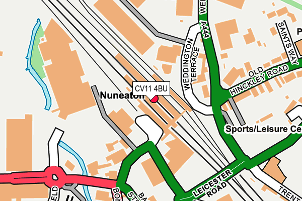
CV11 4BU is located in the Abbey electoral ward, within the local authority district of Nuneaton and Bedworth and the English Parliamentary constituency of Nuneaton. The Sub Integrated Care Board (ICB) Location is NHS Coventry and Warwickshire ICB - B2M3M and the police force is Warwickshire. This postcode has been in use since January 1980.


GetTheData
Source: OS OpenMap – Local (Ordnance Survey)
Source: OS VectorMap District (Ordnance Survey)
Licence: Open Government Licence (requires attribution)
| Easting | 436441 |
| Northing | 292178 |
| Latitude | 52.526280 |
| Longitude | -1.464295 |
GetTheData
Source: Open Postcode Geo
Licence: Open Government Licence
| Country | England |
| Postcode District | CV11 |
| ➜ CV11 open data dashboard ➜ See where CV11 is on a map ➜ Where is Nuneaton? | |
GetTheData
Source: Land Registry Price Paid Data
Licence: Open Government Licence
Elevation or altitude of CV11 4BU as distance above sea level:
| Metres | Feet | |
|---|---|---|
| Elevation | 80m | 262ft |
Elevation is measured from the approximate centre of the postcode, to the nearest point on an OS contour line from OS Terrain 50, which has contour spacing of ten vertical metres.
➜ How high above sea level am I? Find the elevation of your current position using your device's GPS.
GetTheData
Source: Open Postcode Elevation
Licence: Open Government Licence
| Ward | Abbey |
| Constituency | Nuneaton |
GetTheData
Source: ONS Postcode Database
Licence: Open Government Licence
| January 2024 | Other theft | On or near Parking Area | 295m |
| January 2024 | Public order | On or near Parking Area | 295m |
| January 2024 | Violence and sexual offences | On or near Parking Area | 295m |
| ➜ Get more crime data in our Crime section | |||
GetTheData
Source: data.police.uk
Licence: Open Government Licence
| Nuneaton Railway Station (Bond Street) | Nuneaton | 63m |
| Weddington Terrace (Weddington Road) | Nuneaton | 190m |
| Bus Station (Harefield Road) | Nuneaton | 250m |
| Weddington Terrace (Weddington Road) | Nuneaton | 263m |
| Saints Way (Old Hinckley Road) | Nuneaton | 291m |
| Nuneaton Station | 0km |
| Bermuda Park Station | 2.8km |
GetTheData
Source: NaPTAN
Licence: Open Government Licence
GetTheData
Source: ONS Postcode Database
Licence: Open Government Licence


➜ Get more ratings from the Food Standards Agency
GetTheData
Source: Food Standards Agency
Licence: FSA terms & conditions
| Last Collection | |||
|---|---|---|---|
| Location | Mon-Fri | Sat | Distance |
| Br Trent Valley Station | 17:30 | 11:45 | 52m |
| Stockingford Post Office | 17:00 | 12:00 | 157m |
| Harefield Road | 17:15 | 11:30 | 297m |
GetTheData
Source: Dracos
Licence: Creative Commons Attribution-ShareAlike
| Facility | Distance |
|---|---|
| The Crown Inn (Closed) Bond Street, Nuneaton Sports Hall | 138m |
| The Empire Gym & Studios Leicester Road, Nuneaton Health and Fitness Gym, Studio | 183m |
| Etone Sports Centre Leicester Road, Nuneaton Sports Hall, Artificial Grass Pitch, Squash Courts | 362m |
GetTheData
Source: Active Places
Licence: Open Government Licence
| School | Phase of Education | Distance |
|---|---|---|
| Etone College Leicester Road, Nuneaton, CV11 6AA | Secondary | 418m |
| King Edward VI College King Edward Road, Nuneaton, CV11 4BE | 16 plus | 489m |
| Abbey CofE Infant School Aston Road, Nuneaton, CV11 5EL | Primary | 807m |
GetTheData
Source: Edubase
Licence: Open Government Licence
The below table lists the International Territorial Level (ITL) codes (formerly Nomenclature of Territorial Units for Statistics (NUTS) codes) and Local Administrative Units (LAU) codes for CV11 4BU:
| ITL 1 Code | Name |
|---|---|
| TLG | West Midlands (England) |
| ITL 2 Code | Name |
| TLG1 | Herefordshire, Worcestershire and Warwickshire |
| ITL 3 Code | Name |
| TLG13 | Warwickshire CC |
| LAU 1 Code | Name |
| E07000219 | Nuneaton and Bedworth |
GetTheData
Source: ONS Postcode Directory
Licence: Open Government Licence
The below table lists the Census Output Area (OA), Lower Layer Super Output Area (LSOA), and Middle Layer Super Output Area (MSOA) for CV11 4BU:
| Code | Name | |
|---|---|---|
| OA | E00158268 | |
| LSOA | E01031043 | Nuneaton and Bedworth 005A |
| MSOA | E02006479 | Nuneaton and Bedworth 005 |
GetTheData
Source: ONS Postcode Directory
Licence: Open Government Licence
| CV11 4BX | Bond Street | 107m |
| CV11 4DA | Bond Street | 213m |
| CV10 0AA | Old Hinckley Road | 246m |
| CV11 4BS | Orchard Street | 252m |
| CV11 4BL | Regent Street | 255m |
| CV11 4BT | Orchard Street | 279m |
| CV11 4BP | Cooper Street | 298m |
| CV11 4HR | Newtown Road | 306m |
| CV11 6AE | Leicester Road | 310m |
| CV11 6JF | Trent Road | 321m |
GetTheData
Source: Open Postcode Geo; Land Registry Price Paid Data
Licence: Open Government Licence