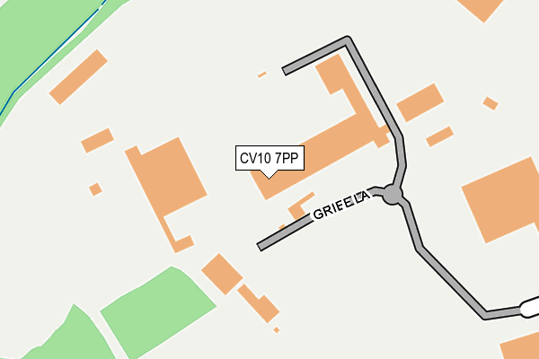
CV10 7PP lies on Griff Clara Industrial Estate in Griff, Nuneaton. CV10 7PP is located in the Arbury electoral ward, within the local authority district of Nuneaton and Bedworth and the English Parliamentary constituency of Nuneaton. The Sub Integrated Care Board (ICB) Location is NHS Coventry and Warwickshire ICB - B2M3M and the police force is Warwickshire. This postcode has been in use since August 1992.


GetTheData
Source: OS OpenMap – Local (Ordnance Survey)
Source: OS VectorMap District (Ordnance Survey)
Licence: Open Government Licence (requires attribution)
| Easting | 434883 |
| Northing | 288995 |
| Latitude | 52.497768 |
| Longitude | -1.487592 |
GetTheData
Source: Open Postcode Geo
Licence: Open Government Licence
| Street | Griff Clara Industrial Estate |
| Locality | Griff |
| Town/City | Nuneaton |
| Country | England |
| Postcode District | CV10 |
| ➜ CV10 open data dashboard ➜ See where CV10 is on a map ➜ Where is Bermuda? | |
GetTheData
Source: Land Registry Price Paid Data
Licence: Open Government Licence
Elevation or altitude of CV10 7PP as distance above sea level:
| Metres | Feet | |
|---|---|---|
| Elevation | 100m | 328ft |
Elevation is measured from the approximate centre of the postcode, to the nearest point on an OS contour line from OS Terrain 50, which has contour spacing of ten vertical metres.
➜ How high above sea level am I? Find the elevation of your current position using your device's GPS.
GetTheData
Source: Open Postcode Elevation
Licence: Open Government Licence
| Ward | Arbury |
| Constituency | Nuneaton |
GetTheData
Source: ONS Postcode Database
Licence: Open Government Licence
| June 2022 | Vehicle crime | On or near Griff Lane | 282m |
| ➜ Get more crime data in our Crime section | |||
GetTheData
Source: data.police.uk
Licence: Open Government Licence
| Walsingham Drive | Nuneaton | 407m |
| National Dairies (Walsingham Drive) | Nuneaton | 459m |
| Cinema (St Davids Way) | Nuneaton | 607m |
| Bermuda Park (St Davids Way) | Nuneaton | 620m |
| Griff House (Coventry Road) | Bedworth | 1,006m |
| Bermuda Park Station | 1.1km |
| Bedworth Station | 2.5km |
| Nuneaton Station | 3.6km |
GetTheData
Source: NaPTAN
Licence: Open Government Licence
GetTheData
Source: ONS Postcode Database
Licence: Open Government Licence


➜ Get more ratings from the Food Standards Agency
GetTheData
Source: Food Standards Agency
Licence: FSA terms & conditions
| Last Collection | |||
|---|---|---|---|
| Location | Mon-Fri | Sat | Distance |
| Bermuda | 17:00 | 07:00 | 1,208m |
| Nuneaton Road | 16:30 | 10:30 | 1,431m |
| Mount Pleasant Road | 16:45 | 12:30 | 1,581m |
GetTheData
Source: Dracos
Licence: Creative Commons Attribution-ShareAlike
| Facility | Distance |
|---|---|
| Nuffield Health (Nuneaton) St. Davids Way, Bermuda Park, Nuneaton Swimming Pool, Health and Fitness Gym, Studio | 621m |
| The Bermuda Phoenix Centre Bermuda Road, Nuneaton Grass Pitches, Sports Hall | 1.2km |
| Collycroft Recreation Ground Nuneaton Road, Bedworth Grass Pitches | 1.4km |
GetTheData
Source: Active Places
Licence: Open Government Licence
| School | Phase of Education | Distance |
|---|---|---|
| Race Leys Junior School Barton Road, Bedworth, CV12 8HG | Primary | 1.6km |
| Glendale Infant School Skye Close, Nuneaton, CV10 7LW | Primary | 1.8km |
| Race Leys Infant School Hurst Road, Bedworth, CV12 8AD | Primary | 1.8km |
GetTheData
Source: Edubase
Licence: Open Government Licence
The below table lists the International Territorial Level (ITL) codes (formerly Nomenclature of Territorial Units for Statistics (NUTS) codes) and Local Administrative Units (LAU) codes for CV10 7PP:
| ITL 1 Code | Name |
|---|---|
| TLG | West Midlands (England) |
| ITL 2 Code | Name |
| TLG1 | Herefordshire, Worcestershire and Warwickshire |
| ITL 3 Code | Name |
| TLG13 | Warwickshire CC |
| LAU 1 Code | Name |
| E07000219 | Nuneaton and Bedworth |
GetTheData
Source: ONS Postcode Directory
Licence: Open Government Licence
The below table lists the Census Output Area (OA), Lower Layer Super Output Area (LSOA), and Middle Layer Super Output Area (MSOA) for CV10 7PP:
| Code | Name | |
|---|---|---|
| OA | E00168283 | |
| LSOA | E01031050 | Nuneaton and Bedworth 008C |
| MSOA | E02006482 | Nuneaton and Bedworth 008 |
GetTheData
Source: ONS Postcode Directory
Licence: Open Government Licence
| CV10 7SE | St Davids Way | 264m |
| CV10 7SD | St Davids Way | 694m |
| CV10 7RW | Walsingham Drive | 789m |
| CV10 7SW | Marigold Walk | 796m |
| CV10 7SY | Petunia Close | 846m |
| CV10 7SR | Carnation Way | 852m |
| CV10 7RT | Iris Avenue | 857m |
| CV10 7SX | Fuchsia Close | 859m |
| CV10 7SQ | Dahlia Walk | 902m |
| CV10 7SP | Aster Walk | 915m |
GetTheData
Source: Open Postcode Geo; Land Registry Price Paid Data
Licence: Open Government Licence