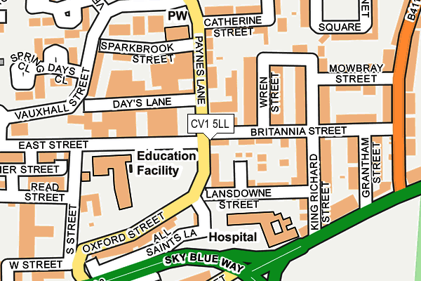
CV1 5LL is located in the St Michael's electoral ward, within the metropolitan district of Coventry and the English Parliamentary constituency of Coventry South. The Sub Integrated Care Board (ICB) Location is NHS Coventry and Warwickshire ICB - B2M3M and the police force is West Midlands. This postcode has been in use since January 1980.


GetTheData
Source: OS OpenMap – Local (Ordnance Survey)
Source: OS VectorMap District (Ordnance Survey)
Licence: Open Government Licence (requires attribution)
| Easting | 434600 |
| Northing | 279251 |
| Latitude | 52.410174 |
| Longitude | -1.492775 |
GetTheData
Source: Open Postcode Geo
Licence: Open Government Licence
| Country | England |
| Postcode District | CV1 |
| ➜ CV1 open data dashboard ➜ See where CV1 is on a map ➜ Where is Coventry? | |
GetTheData
Source: Land Registry Price Paid Data
Licence: Open Government Licence
Elevation or altitude of CV1 5LL as distance above sea level:
| Metres | Feet | |
|---|---|---|
| Elevation | 80m | 262ft |
Elevation is measured from the approximate centre of the postcode, to the nearest point on an OS contour line from OS Terrain 50, which has contour spacing of ten vertical metres.
➜ How high above sea level am I? Find the elevation of your current position using your device's GPS.
GetTheData
Source: Open Postcode Elevation
Licence: Open Government Licence
| Ward | St Michael's |
| Constituency | Coventry South |
GetTheData
Source: ONS Postcode Database
Licence: Open Government Licence
| July 2023 | Violence and sexual offences | On or near Vernon Close | 266m |
| January 2023 | Violence and sexual offences | On or near Vernon Close | 266m |
| December 2022 | Other theft | On or near Vernon Close | 266m |
| ➜ Get more crime data in our Crime section | |||
GetTheData
Source: data.police.uk
Licence: Open Government Licence
| Days Lane (Paynes Lane) | Gosford Green | 39m |
| Days Lane (Paynes Lane) | Gosford Green | 50m |
| All Saints Lane (Oxford St) | Gosford Green | 108m |
| All Saints Lane (Oxford St) | Gosford Green | 118m |
| Gosford Green (Sky Blue Way) | Gosford Green | 149m |
| Coventry Station | 1.8km |
| Canley Station | 3.9km |
| Coventry Arena Station | 4.2km |
GetTheData
Source: NaPTAN
Licence: Open Government Licence
GetTheData
Source: ONS Postcode Database
Licence: Open Government Licence


➜ Get more ratings from the Food Standards Agency
GetTheData
Source: Food Standards Agency
Licence: FSA terms & conditions
| Last Collection | |||
|---|---|---|---|
| Location | Mon-Fri | Sat | Distance |
| Paynes Lane | 18:45 | 09:45 | 49m |
| Grafton Street | 19:00 | 10:00 | 262m |
| Swan Lane | 16:30 | 09:45 | 275m |
GetTheData
Source: Dracos
Licence: Creative Commons Attribution-ShareAlike
| Facility | Distance |
|---|---|
| Future Fitness (Coventry) Far Gosford Street, Coventry Health and Fitness Gym | 345m |
| St Mary And St Benedict Catholic Primary School Leigh Street, Coventry Grass Pitches | 499m |
| Peupeot Valbot Sports Ground (Closed) Humber Road, Coventry Grass Pitches | 630m |
GetTheData
Source: Active Places
Licence: Open Government Licence
| School | Phase of Education | Distance |
|---|---|---|
| Summit School Cygnet Joyce Parker Hospital, 2 Lansdown Street, Coventry, CV2 4BF | Not applicable | 93m |
| Southfields Primary School East Street, Coventry, CV1 5LS | Primary | 142m |
| St Mary and St Benedict Catholic Primary School Leigh Street, Hillfields, Coventry, CV1 5HG | Primary | 503m |
GetTheData
Source: Edubase
Licence: Open Government Licence
The below table lists the International Territorial Level (ITL) codes (formerly Nomenclature of Territorial Units for Statistics (NUTS) codes) and Local Administrative Units (LAU) codes for CV1 5LL:
| ITL 1 Code | Name |
|---|---|
| TLG | West Midlands (England) |
| ITL 2 Code | Name |
| TLG3 | West Midlands |
| ITL 3 Code | Name |
| TLG33 | Coventry |
| LAU 1 Code | Name |
| E08000026 | Coventry |
GetTheData
Source: ONS Postcode Directory
Licence: Open Government Licence
The below table lists the Census Output Area (OA), Lower Layer Super Output Area (LSOA), and Middle Layer Super Output Area (MSOA) for CV1 5LL:
| Code | Name | |
|---|---|---|
| OA | E00048757 | |
| LSOA | E01009641 | Coventry 024F |
| MSOA | E02001981 | Coventry 024 |
GetTheData
Source: ONS Postcode Directory
Licence: Open Government Licence
| CV2 4FS | Britannia Street | 38m |
| CV2 4RJ | Brunel Close | 78m |
| CV1 5LJ | Paynes Lane | 86m |
| CV2 4FT | Wren Street | 92m |
| CV2 4FN | Lansdowne Street | 93m |
| CV2 4FR | Britannia Street | 105m |
| CV1 5LN | Paynes Lane | 114m |
| CV2 4FU | King Richard Street | 140m |
| CV2 4FX | King Richard Street | 145m |
| CV1 5LA | Sparkbrook Street | 173m |
GetTheData
Source: Open Postcode Geo; Land Registry Price Paid Data
Licence: Open Government Licence