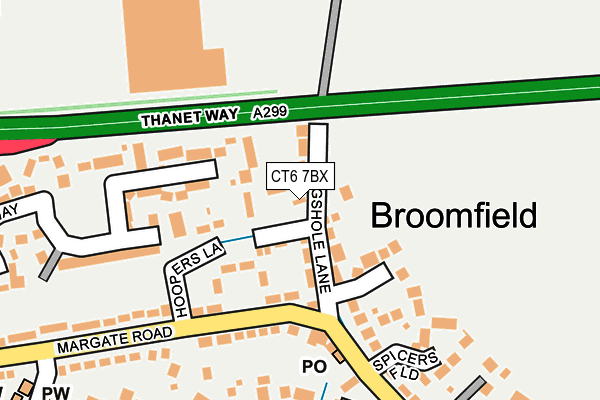
CT6 7BX is located in the Herne & Broomfield electoral ward, within the local authority district of Canterbury and the English Parliamentary constituency of North Thanet. The Sub Integrated Care Board (ICB) Location is NHS Kent and Medway ICB - 91Q and the police force is Kent. This postcode has been in use since January 1980.


GetTheData
Source: OS OpenMap – Local (Ordnance Survey)
Source: OS VectorMap District (Ordnance Survey)
Licence: Open Government Licence (requires attribution)
| Easting | 619754 |
| Northing | 167038 |
| Latitude | 51.359884 |
| Longitude | 1.155105 |
GetTheData
Source: Open Postcode Geo
Licence: Open Government Licence
| Country | England |
| Postcode District | CT6 |
| ➜ CT6 open data dashboard ➜ See where CT6 is on a map ➜ Where is Broomfield? | |
GetTheData
Source: Land Registry Price Paid Data
Licence: Open Government Licence
Elevation or altitude of CT6 7BX as distance above sea level:
| Metres | Feet | |
|---|---|---|
| Elevation | 40m | 131ft |
Elevation is measured from the approximate centre of the postcode, to the nearest point on an OS contour line from OS Terrain 50, which has contour spacing of ten vertical metres.
➜ How high above sea level am I? Find the elevation of your current position using your device's GPS.
GetTheData
Source: Open Postcode Elevation
Licence: Open Government Licence
| Ward | Herne & Broomfield |
| Constituency | North Thanet |
GetTheData
Source: ONS Postcode Database
Licence: Open Government Licence
| December 2023 | Vehicle crime | On or near Spicers Field | 187m |
| September 2023 | Anti-social behaviour | On or near Hoopers Lane | 61m |
| August 2023 | Violence and sexual offences | On or near Hoopers Lane | 61m |
| ➜ Get more crime data in our Crime section | |||
GetTheData
Source: data.police.uk
Licence: Open Government Licence
| Hoopers Lane (Margate Road) | Broomfield | 121m |
| Hoopers Lane (Margate Road) | Broomfield | 158m |
| Margate Road The Plough (Margate Road) | Broomfield | 370m |
| Huntsman And Horn (Margate Road) | Broomfield | 370m |
| Huntsman And Horn (Margate Road) | Broomfield | 384m |
| Herne Bay Station | 2.7km |
GetTheData
Source: NaPTAN
Licence: Open Government Licence
| Percentage of properties with Next Generation Access | 100.0% |
| Percentage of properties with Superfast Broadband | 100.0% |
| Percentage of properties with Ultrafast Broadband | 0.0% |
| Percentage of properties with Full Fibre Broadband | 0.0% |
Superfast Broadband is between 30Mbps and 300Mbps
Ultrafast Broadband is > 300Mbps
| Percentage of properties unable to receive 2Mbps | 0.0% |
| Percentage of properties unable to receive 5Mbps | 0.0% |
| Percentage of properties unable to receive 10Mbps | 0.0% |
| Percentage of properties unable to receive 30Mbps | 0.0% |
GetTheData
Source: Ofcom
Licence: Ofcom Terms of Use (requires attribution)
GetTheData
Source: ONS Postcode Database
Licence: Open Government Licence


➜ Get more ratings from the Food Standards Agency
GetTheData
Source: Food Standards Agency
Licence: FSA terms & conditions
| Last Collection | |||
|---|---|---|---|
| Location | Mon-Fri | Sat | Distance |
| Broomfield Post Office | 17:00 | 11:45 | 164m |
| Hunters Forstal | 16:15 | 11:00 | 458m |
| Blacksole | 17:00 | 11:00 | 835m |
GetTheData
Source: Dracos
Licence: Creative Commons Attribution-ShareAlike
| Facility | Distance |
|---|---|
| Snap Fitness (Herne Bay) The Boulevard, The Boulevard, Altira Business Park, Herne Bay Health and Fitness Gym | 216m |
| Broomfield Bmx Track Ford Road, Herne Cycling | 877m |
| Burton Downs Recreation Ground Thundersland Road, Herne Bay Grass Pitches | 1.3km |
GetTheData
Source: Active Places
Licence: Open Government Licence
| School | Phase of Education | Distance |
|---|---|---|
| Herne Church of England Infant and Nursery School Palmer Close, Herne, Herne Bay, CT6 7AH | Primary | 1.6km |
| Reculver Church of England Primary School Hillborough, Herne Bay, CT6 6TA | Primary | 1.7km |
| Herne Church of England Junior School School Lane, Herne, Herne Bay, CT6 7AL | Primary | 1.7km |
GetTheData
Source: Edubase
Licence: Open Government Licence
The below table lists the International Territorial Level (ITL) codes (formerly Nomenclature of Territorial Units for Statistics (NUTS) codes) and Local Administrative Units (LAU) codes for CT6 7BX:
| ITL 1 Code | Name |
|---|---|
| TLJ | South East (England) |
| ITL 2 Code | Name |
| TLJ4 | Kent |
| ITL 3 Code | Name |
| TLJ44 | East Kent |
| LAU 1 Code | Name |
| E07000106 | Canterbury |
GetTheData
Source: ONS Postcode Directory
Licence: Open Government Licence
The below table lists the Census Output Area (OA), Lower Layer Super Output Area (LSOA), and Middle Layer Super Output Area (MSOA) for CT6 7BX:
| Code | Name | |
|---|---|---|
| OA | E00122233 | |
| LSOA | E01024076 | Canterbury 006D |
| MSOA | E02005015 | Canterbury 006 |
GetTheData
Source: ONS Postcode Directory
Licence: Open Government Licence
| CT6 7BS | Bogshole Lane | 33m |
| CT6 7BU | Bogshole Lane | 38m |
| CT6 7BT | Belle Vue Cottages | 43m |
| CT6 7BY | Bogshole Lane | 53m |
| CT6 7BZ | Bogshole Lane | 55m |
| CT6 7BP | Hoopers Lane | 65m |
| CT6 7BJ | Margate Road | 138m |
| CT6 7DS | Bramley Gardens | 145m |
| CT6 7AG | Margate Road | 153m |
| CT6 7GG | Spicers Field | 220m |
GetTheData
Source: Open Postcode Geo; Land Registry Price Paid Data
Licence: Open Government Licence