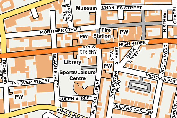
CT6 5NY is located in the Heron electoral ward, within the local authority district of Canterbury and the English Parliamentary constituency of North Thanet. The Sub Integrated Care Board (ICB) Location is NHS Kent and Medway ICB - 91Q and the police force is Kent. This postcode has been in use since January 1980.


GetTheData
Source: OS OpenMap – Local (Ordnance Survey)
Source: OS VectorMap District (Ordnance Survey)
Licence: Open Government Licence (requires attribution)
| Easting | 617812 |
| Northing | 168189 |
| Latitude | 51.370965 |
| Longitude | 1.127960 |
GetTheData
Source: Open Postcode Geo
Licence: Open Government Licence
| Country | England |
| Postcode District | CT6 |
| ➜ CT6 open data dashboard ➜ See where CT6 is on a map ➜ Where is Herne Bay? | |
GetTheData
Source: Land Registry Price Paid Data
Licence: Open Government Licence
Elevation or altitude of CT6 5NY as distance above sea level:
| Metres | Feet | |
|---|---|---|
| Elevation | 10m | 33ft |
Elevation is measured from the approximate centre of the postcode, to the nearest point on an OS contour line from OS Terrain 50, which has contour spacing of ten vertical metres.
➜ How high above sea level am I? Find the elevation of your current position using your device's GPS.
GetTheData
Source: Open Postcode Elevation
Licence: Open Government Licence
| Ward | Heron |
| Constituency | North Thanet |
GetTheData
Source: ONS Postcode Database
Licence: Open Government Licence
| January 2024 | Violence and sexual offences | On or near Parking Area | 197m |
| December 2023 | Criminal damage and arson | On or near Parking Area | 191m |
| December 2023 | Other theft | On or near Parking Area | 197m |
| ➜ Get more crime data in our Crime section | |||
GetTheData
Source: data.police.uk
Licence: Open Government Licence
| Library (High Street) | Herne Bay | 55m |
| Fire Station (High Street) | Herne Bay | 95m |
| Fire Station (High Street) | Herne Bay | 106m |
| Bus Depot (High Street) | Herne Bay | 226m |
| Bus Depot (High Street) | Herne Bay | 252m |
| Herne Bay Station | 1km |
| Chestfield & Swalecliffe Station | 4.4km |
GetTheData
Source: NaPTAN
Licence: Open Government Licence
GetTheData
Source: ONS Postcode Database
Licence: Open Government Licence


➜ Get more ratings from the Food Standards Agency
GetTheData
Source: Food Standards Agency
Licence: FSA terms & conditions
| Last Collection | |||
|---|---|---|---|
| Location | Mon-Fri | Sat | Distance |
| High Street | 17:45 | 11:45 | 45m |
| High Street | 17:45 | 45m | |
| William Street Post Office | 16:15 | 11:45 | 146m |
GetTheData
Source: Dracos
Licence: Creative Commons Attribution-ShareAlike
| Facility | Distance |
|---|---|
| Urban Fitness New Street, Herne Bay Health and Fitness Gym | 71m |
| Herons Leisure Centre William Street, Herne Bay Swimming Pool, Health and Fitness Gym, Studio | 112m |
| Herne Bay Memorial Park Park Road, Herne Bay Grass Pitches, Outdoor Tennis Courts | 343m |
GetTheData
Source: Active Places
Licence: Open Government Licence
| School | Phase of Education | Distance |
|---|---|---|
| Herne Bay Junior School Kings Road, Herne Bay, CT6 5DA | Primary | 285m |
| Herne Bay Infant School Stanley Road, Herne Bay, CT6 5SH | Primary | 331m |
| Fairlight Glen Independent Special School Verona House, 45 Station Road, Herne Bay, CT6 5QQ | Not applicable | 701m |
GetTheData
Source: Edubase
Licence: Open Government Licence
The below table lists the International Territorial Level (ITL) codes (formerly Nomenclature of Territorial Units for Statistics (NUTS) codes) and Local Administrative Units (LAU) codes for CT6 5NY:
| ITL 1 Code | Name |
|---|---|
| TLJ | South East (England) |
| ITL 2 Code | Name |
| TLJ4 | Kent |
| ITL 3 Code | Name |
| TLJ44 | East Kent |
| LAU 1 Code | Name |
| E07000106 | Canterbury |
GetTheData
Source: ONS Postcode Directory
Licence: Open Government Licence
The below table lists the Census Output Area (OA), Lower Layer Super Output Area (LSOA), and Middle Layer Super Output Area (MSOA) for CT6 5NY:
| Code | Name | |
|---|---|---|
| OA | E00122263 | |
| LSOA | E01024078 | Canterbury 001A |
| MSOA | E02005010 | Canterbury 001 |
GetTheData
Source: ONS Postcode Directory
Licence: Open Government Licence
| CT6 5NU | William Street | 15m |
| CT6 5LA | High Street | 58m |
| CT6 5JY | High Street | 61m |
| CT6 5NW | High Street | 73m |
| CT6 5AG | New Street | 76m |
| CT6 5AH | New Street | 83m |
| CT6 5NG | High Street | 86m |
| CT6 5EG | William Street | 93m |
| CT6 5PS | Mortimer Street | 105m |
| CT6 5NR | William Street | 110m |
GetTheData
Source: Open Postcode Geo; Land Registry Price Paid Data
Licence: Open Government Licence