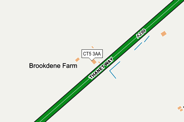
CT5 3AA is located in the Seasalter electoral ward, within the local authority district of Canterbury and the English Parliamentary constituency of Canterbury. The Sub Integrated Care Board (ICB) Location is NHS Kent and Medway ICB - 91Q and the police force is Kent. This postcode has been in use since September 1991.


GetTheData
Source: OS OpenMap – Local (Ordnance Survey)
Source: OS VectorMap District (Ordnance Survey)
Licence: Open Government Licence (requires attribution)
| Easting | 608782 |
| Northing | 163160 |
| Latitude | 51.329201 |
| Longitude | 0.995501 |
GetTheData
Source: Open Postcode Geo
Licence: Open Government Licence
| Country | England |
| Postcode District | CT5 |
| ➜ CT5 open data dashboard ➜ See where CT5 is on a map | |
GetTheData
Source: Land Registry Price Paid Data
Licence: Open Government Licence
Elevation or altitude of CT5 3AA as distance above sea level:
| Metres | Feet | |
|---|---|---|
| Elevation | 10m | 33ft |
Elevation is measured from the approximate centre of the postcode, to the nearest point on an OS contour line from OS Terrain 50, which has contour spacing of ten vertical metres.
➜ How high above sea level am I? Find the elevation of your current position using your device's GPS.
GetTheData
Source: Open Postcode Elevation
Licence: Open Government Licence
| Ward | Seasalter |
| Constituency | Canterbury |
GetTheData
Source: ONS Postcode Database
Licence: Open Government Licence
| June 2022 | Violence and sexual offences | On or near Glen Walk | 438m |
| May 2022 | Criminal damage and arson | On or near Glen Walk | 438m |
| March 2022 | Vehicle crime | On or near Barn Close | 272m |
| ➜ Get more crime data in our Crime section | |||
GetTheData
Source: data.police.uk
Licence: Open Government Licence
| Barn Close (Dargate Road) | Yorkletts | 293m |
| Barn Close (Dargate Road) | Yorkletts | 312m |
| Plumpudding Lane (Highstreet Road) | Yorkletts | 636m |
| Plumpudding Lane (Highstreet Road) | Yorkletts | 650m |
| Estuary View Medical Centre (Thanet Way) | Whitstable | 1,900m |
| Whitstable Station | 4.1km |
| Chestfield & Swalecliffe Station | 6.1km |
GetTheData
Source: NaPTAN
Licence: Open Government Licence
| Percentage of properties with Next Generation Access | 100.0% |
| Percentage of properties with Superfast Broadband | 100.0% |
| Percentage of properties with Ultrafast Broadband | 0.0% |
| Percentage of properties with Full Fibre Broadband | 0.0% |
Superfast Broadband is between 30Mbps and 300Mbps
Ultrafast Broadband is > 300Mbps
| Percentage of properties unable to receive 2Mbps | 0.0% |
| Percentage of properties unable to receive 5Mbps | 0.0% |
| Percentage of properties unable to receive 10Mbps | 0.0% |
| Percentage of properties unable to receive 30Mbps | 0.0% |
GetTheData
Source: Ofcom
Licence: Ofcom Terms of Use (requires attribution)
GetTheData
Source: ONS Postcode Database
Licence: Open Government Licence


➜ Get more ratings from the Food Standards Agency
GetTheData
Source: Food Standards Agency
Licence: FSA terms & conditions
| Last Collection | |||
|---|---|---|---|
| Location | Mon-Fri | Sat | Distance |
| Yorkletts | 16:30 | 10:00 | 304m |
| Hernhill High Street | 16:45 | 09:30 | 668m |
| Seasalter Cross | 16:00 | 11:45 | 1,686m |
GetTheData
Source: Dracos
Licence: Creative Commons Attribution-ShareAlike
| Facility | Distance |
|---|---|
| Joy Lane Junior School Joy Lane, Whitstable Grass Pitches, Swimming Pool | 2.7km |
| Hernhill Playing Field Fostall, Hernhill, Faversham Grass Pitches, Outdoor Tennis Courts | 3km |
| Whitstable And Seasalter Golf Course Collingwood Road, Whitstable Golf | 3.4km |
GetTheData
Source: Active Places
Licence: Open Government Licence
| School | Phase of Education | Distance |
|---|---|---|
| Hernhill Church of England Primary School Fostall, Hernhill, Faversham, ME13 9JG | Primary | 2.7km |
| Joy Lane Primary Foundation School Joy Lane, Whitstable, CT5 4LT | Primary | 2.7km |
| Whitstable Junior School Oxford Street, Whitstable, CT5 1DB | Primary | 3.6km |
GetTheData
Source: Edubase
Licence: Open Government Licence
The below table lists the International Territorial Level (ITL) codes (formerly Nomenclature of Territorial Units for Statistics (NUTS) codes) and Local Administrative Units (LAU) codes for CT5 3AA:
| ITL 1 Code | Name |
|---|---|
| TLJ | South East (England) |
| ITL 2 Code | Name |
| TLJ4 | Kent |
| ITL 3 Code | Name |
| TLJ44 | East Kent |
| LAU 1 Code | Name |
| E07000106 | Canterbury |
GetTheData
Source: ONS Postcode Directory
Licence: Open Government Licence
The below table lists the Census Output Area (OA), Lower Layer Super Output Area (LSOA), and Middle Layer Super Output Area (MSOA) for CT5 3AA:
| Code | Name | |
|---|---|---|
| OA | E00122399 | |
| LSOA | E01024109 | Canterbury 009E |
| MSOA | E02005018 | Canterbury 009 |
GetTheData
Source: ONS Postcode Directory
Licence: Open Government Licence
| CT5 3AF | Barn Close | 256m |
| CT5 3AG | Dargate Road | 262m |
| CT5 3AE | Dargate Road | 348m |
| CT5 3AH | Dargate Road | 393m |
| CT5 3AB | Dargate Road | 404m |
| CT5 3AD | Dargate Road | 409m |
| CT5 4BT | Seasalter Lane | 435m |
| CT5 3AJ | Ford Walk | 461m |
| CT5 3AN | Glen Walk | 478m |
| CT5 3AL | Coombe Walk | 514m |
GetTheData
Source: Open Postcode Geo; Land Registry Price Paid Data
Licence: Open Government Licence