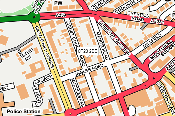
CT20 2DE lies on Ingles Road in Folkestone. CT20 2DE is located in the Folkestone Central electoral ward, within the local authority district of Folkestone and Hythe and the English Parliamentary constituency of Folkestone and Hythe. The Sub Integrated Care Board (ICB) Location is NHS Kent and Medway ICB - 91Q and the police force is Kent. This postcode has been in use since August 2014.


GetTheData
Source: OS OpenMap – Local (Ordnance Survey)
Source: OS VectorMap District (Ordnance Survey)
Licence: Open Government Licence (requires attribution)
| Easting | 622309 |
| Northing | 135954 |
| Latitude | 51.079818 |
| Longitude | 1.172486 |
GetTheData
Source: Open Postcode Geo
Licence: Open Government Licence
| Street | Ingles Road |
| Town/City | Folkestone |
| Country | England |
| Postcode District | CT20 |
| ➜ CT20 open data dashboard ➜ See where CT20 is on a map ➜ Where is Folkestone? | |
GetTheData
Source: Land Registry Price Paid Data
Licence: Open Government Licence
Elevation or altitude of CT20 2DE as distance above sea level:
| Metres | Feet | |
|---|---|---|
| Elevation | 40m | 131ft |
Elevation is measured from the approximate centre of the postcode, to the nearest point on an OS contour line from OS Terrain 50, which has contour spacing of ten vertical metres.
➜ How high above sea level am I? Find the elevation of your current position using your device's GPS.
GetTheData
Source: Open Postcode Elevation
Licence: Open Government Licence
| Ward | Folkestone Central |
| Constituency | Folkestone And Hythe |
GetTheData
Source: ONS Postcode Database
Licence: Open Government Licence
| January 2024 | Anti-social behaviour | On or near Parking Area | 350m |
| January 2024 | Other theft | On or near Parking Area | 350m |
| January 2024 | Violence and sexual offences | On or near Parking Area | 350m |
| ➜ Ingles Road crime map and outcomes | |||
GetTheData
Source: data.police.uk
Licence: Open Government Licence
| Civic Centre (Castle Hill Avenue) | Folkestone | 143m |
| Bouverie Road West | Folkestone | 161m |
| Civic Centre (Castle Hill Avenue) | Folkestone | 164m |
| Bouverie Road West | Folkestone | 184m |
| Connaught Road (Cheriton Road) | Folkestone | 222m |
| Folkestone Central Station | 0.4km |
| Folkestone West Station | 1.4km |
GetTheData
Source: NaPTAN
Licence: Open Government Licence
| Median download speed | 55.0Mbps |
| Average download speed | 46.5Mbps |
| Maximum download speed | 80.00Mbps |
| Median upload speed | 10.0Mbps |
| Average upload speed | 9.2Mbps |
| Maximum upload speed | 20.00Mbps |
GetTheData
Source: Ofcom
Licence: Ofcom Terms of Use (requires attribution)
Estimated total energy consumption in CT20 2DE by fuel type, 2015.
| Consumption (kWh) | 100,681 |
|---|---|
| Meter count | 16 |
| Mean (kWh/meter) | 6,293 |
| Median (kWh/meter) | 4,978 |
GetTheData
Source: Postcode level gas estimates: 2015 (experimental)
Source: Postcode level electricity estimates: 2015 (experimental)
Licence: Open Government Licence
GetTheData
Source: ONS Postcode Database
Licence: Open Government Licence


➜ Get more ratings from the Food Standards Agency
GetTheData
Source: Food Standards Agency
Licence: FSA terms & conditions
| Last Collection | |||
|---|---|---|---|
| Location | Mon-Fri | Sat | Distance |
| Ingles Road | 17:45 | 12:00 | 32m |
| Cheriton Avenue (Ex T S O) | 18:00 | 12:00 | 254m |
| Millfield | 17:30 | 12:00 | 298m |
GetTheData
Source: Dracos
Licence: Creative Commons Attribution-ShareAlike
| Facility | Distance |
|---|---|
| Christ Church Cep Academy Brockman Road, Folkestone Grass Pitches | 363m |
| Fit One Sandgate Road, Folkestone Health and Fitness Gym, Studio | 364m |
| Folkstone Constitutional Club (Closed) Guildhall Street, Folkestone Sports Hall | 443m |
GetTheData
Source: Active Places
Licence: Open Government Licence
| School | Phase of Education | Distance |
|---|---|---|
| Christ Church Cep Academy, Folkestone Brockman Road, Folkestone, CT20 1DJ | Primary | 363m |
| Earlscliffe (Sussex Summer Schools Ltd) 29 Shorncliffe Road, Folkestone, CT20 2NB | Not applicable | 600m |
| Compass Community School Coastal Park Heather Lodge, 2 Radnor Park West, Folkestone, CT19 5HH | Not applicable | 612m |
GetTheData
Source: Edubase
Licence: Open Government Licence
The below table lists the International Territorial Level (ITL) codes (formerly Nomenclature of Territorial Units for Statistics (NUTS) codes) and Local Administrative Units (LAU) codes for CT20 2DE:
| ITL 1 Code | Name |
|---|---|
| TLJ | South East (England) |
| ITL 2 Code | Name |
| TLJ4 | Kent |
| ITL 3 Code | Name |
| TLJ44 | East Kent |
| LAU 1 Code | Name |
| E07000112 | Folkestone and Hythe |
GetTheData
Source: ONS Postcode Directory
Licence: Open Government Licence
The below table lists the Census Output Area (OA), Lower Layer Super Output Area (LSOA), and Middle Layer Super Output Area (MSOA) for CT20 2DE:
| Code | Name | |
|---|---|---|
| OA | E00124384 | |
| LSOA | E01024508 | Shepway 015A |
| MSOA | E02006880 | Shepway 015 |
GetTheData
Source: ONS Postcode Directory
Licence: Open Government Licence
| CT20 2SW | Shelleys Mews | 55m |
| CT20 2SU | Christ Church Road | 63m |
| CT20 2SN | Ingles Road | 76m |
| CT20 2SL | Christ Church Road | 82m |
| CT20 2SJ | Christ Church Road | 88m |
| CT20 2SE | Manor Road | 92m |
| CT20 2SD | Ingles Mews | 93m |
| CT20 2SA | Manor Road | 97m |
| CT20 2RE | Castle Hill Avenue | 108m |
| CT20 2SS | Christ Church Road | 109m |
GetTheData
Source: Open Postcode Geo; Land Registry Price Paid Data
Licence: Open Government Licence