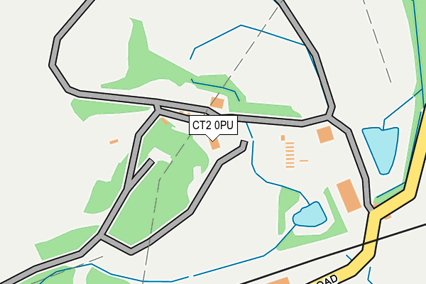
CT2 0PU is located in the Blean Forest electoral ward, within the local authority district of Canterbury and the English Parliamentary constituency of Canterbury. The Sub Integrated Care Board (ICB) Location is NHS Kent and Medway ICB - 91Q and the police force is Kent. This postcode has been in use since February 1990.


GetTheData
Source: OS OpenMap – Local (Ordnance Survey)
Source: OS VectorMap District (Ordnance Survey)
Licence: Open Government Licence (requires attribution)
| Easting | 616336 |
| Northing | 160156 |
| Latitude | 51.299409 |
| Longitude | 1.101942 |
GetTheData
Source: Open Postcode Geo
Licence: Open Government Licence
| Country | England |
| Postcode District | CT2 |
| ➜ CT2 open data dashboard ➜ See where CT2 is on a map | |
GetTheData
Source: Land Registry Price Paid Data
Licence: Open Government Licence
Elevation or altitude of CT2 0PU as distance above sea level:
| Metres | Feet | |
|---|---|---|
| Elevation | 20m | 66ft |
Elevation is measured from the approximate centre of the postcode, to the nearest point on an OS contour line from OS Terrain 50, which has contour spacing of ten vertical metres.
➜ How high above sea level am I? Find the elevation of your current position using your device's GPS.
GetTheData
Source: Open Postcode Elevation
Licence: Open Government Licence
| Ward | Blean Forest |
| Constituency | Canterbury |
GetTheData
Source: ONS Postcode Database
Licence: Open Government Licence
| June 2022 | Other theft | On or near Petrol Station | 496m |
| May 2022 | Vehicle crime | On or near Vauxhall Road | 313m |
| May 2022 | Robbery | On or near Vauxhall Road | 313m |
| ➜ Get more crime data in our Crime section | |||
GetTheData
Source: data.police.uk
Licence: Open Government Licence
| Sturry Road Park And Ride Terminal (Sturry Road) | Vauxhall | 750m |
| Sturry Road Park And Ride Terminal (Sturry Road) | Vauxhall | 780m |
| Vauxhall Road (Sturry Road) | Vauxhall | 786m |
| Dengrove (Shalloak Road) | Broad Oak | 790m |
| Dengrove (Shalloak Road) | Broad Oak | 799m |
| Sturry Station | 1.4km |
| Canterbury West Station | 2.5km |
| Canterbury East Station | 3.3km |
GetTheData
Source: NaPTAN
Licence: Open Government Licence
GetTheData
Source: ONS Postcode Database
Licence: Open Government Licence


➜ Get more ratings from the Food Standards Agency
GetTheData
Source: Food Standards Agency
Licence: FSA terms & conditions
| Last Collection | |||
|---|---|---|---|
| Location | Mon-Fri | Sat | Distance |
| Vauxhall Road | 17:30 | 11:45 | 678m |
| Dengrove | 16:15 | 09:45 | 812m |
| Sturry Road Post Office | 17:30 | 11:45 | 881m |
GetTheData
Source: Dracos
Licence: Creative Commons Attribution-ShareAlike
| Facility | Distance |
|---|---|
| Everlast Gyms (Canterbury) Vauxhall Road, Canterbury Health and Fitness Gym, Swimming Pool, Studio | 744m |
| Puregym (Canterbury Sturry Road) Marshwood Close, Canterbury Health and Fitness Gym | 1km |
| Junior King's School Sturry, Canterbury Grass Pitches, Sports Hall, Swimming Pool, Artificial Grass Pitch, Outdoor Tennis Courts | 1.2km |
GetTheData
Source: Active Places
Licence: Open Government Licence
| School | Phase of Education | Distance |
|---|---|---|
| Parkside Community Primary School Tennyson Avenue, Canterbury, CT1 1EP | Primary | 1.2km |
| Junior King's School Milner Court, Sturry, Canterbury, CT2 0AY | Not applicable | 1.3km |
| St Stephen's Junior School Hales Drive, St Stephens, Canterbury, CT2 7AD | Primary | 1.7km |
GetTheData
Source: Edubase
Licence: Open Government Licence
The below table lists the International Territorial Level (ITL) codes (formerly Nomenclature of Territorial Units for Statistics (NUTS) codes) and Local Administrative Units (LAU) codes for CT2 0PU:
| ITL 1 Code | Name |
|---|---|
| TLJ | South East (England) |
| ITL 2 Code | Name |
| TLJ4 | Kent |
| ITL 3 Code | Name |
| TLJ44 | East Kent |
| LAU 1 Code | Name |
| E07000106 | Canterbury |
GetTheData
Source: ONS Postcode Directory
Licence: Open Government Licence
The below table lists the Census Output Area (OA), Lower Layer Super Output Area (LSOA), and Middle Layer Super Output Area (MSOA) for CT2 0PU:
| Code | Name | |
|---|---|---|
| OA | E00122103 | |
| LSOA | E01032809 | Canterbury 012F |
| MSOA | E02005021 | Canterbury 012 |
GetTheData
Source: ONS Postcode Directory
Licence: Open Government Licence
| CT2 0PR | Shalloak Road | 203m |
| CT2 0PS | Shalloak Road | 623m |
| CT2 0PT | Shalloak Road | 710m |
| CT2 0QD | Shalloak Road | 724m |
| CT1 1EX | Vauxhall Avenue | 738m |
| CT1 1EY | Vauxhall Crescent | 756m |
| CT1 1HG | Sturry Road | 800m |
| CT1 1AD | Stour Retail Park | 841m |
| CT2 0AA | Sturry Road | 844m |
| CT1 1EU | Vauxhall Avenue | 851m |
GetTheData
Source: Open Postcode Geo; Land Registry Price Paid Data
Licence: Open Government Licence