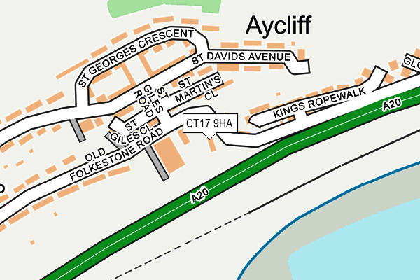
CT17 9HA lies on Townsend Terrace in Dover. CT17 9HA is located in the Town & Castle electoral ward, within the local authority district of Dover and the English Parliamentary constituency of Dover. The Sub Integrated Care Board (ICB) Location is NHS Kent and Medway ICB - 91Q and the police force is Kent. This postcode has been in use since December 1998.


GetTheData
Source: OS OpenMap – Local (Ordnance Survey)
Source: OS VectorMap District (Ordnance Survey)
Licence: Open Government Licence (requires attribution)
| Easting | 630760 |
| Northing | 140060 |
| Latitude | 51.113345 |
| Longitude | 1.295551 |
GetTheData
Source: Open Postcode Geo
Licence: Open Government Licence
| Street | Townsend Terrace |
| Town/City | Dover |
| Country | England |
| Postcode District | CT17 |
| ➜ CT17 open data dashboard ➜ See where CT17 is on a map ➜ Where is Dover? | |
GetTheData
Source: Land Registry Price Paid Data
Licence: Open Government Licence
Elevation or altitude of CT17 9HA as distance above sea level:
| Metres | Feet | |
|---|---|---|
| Elevation | 40m | 131ft |
Elevation is measured from the approximate centre of the postcode, to the nearest point on an OS contour line from OS Terrain 50, which has contour spacing of ten vertical metres.
➜ How high above sea level am I? Find the elevation of your current position using your device's GPS.
GetTheData
Source: Open Postcode Elevation
Licence: Open Government Licence
| Ward | Town & Castle |
| Constituency | Dover |
GetTheData
Source: ONS Postcode Database
Licence: Open Government Licence
| June 2022 | Anti-social behaviour | On or near St Giles Road | 90m |
| June 2022 | Theft from the person | On or near Gloster Way | 428m |
| May 2022 | Criminal damage and arson | On or near St Giles Road | 90m |
| ➜ Get more crime data in our Crime section | |||
GetTheData
Source: data.police.uk
Licence: Open Government Licence
| St Giles Road (Old Folkestone Road) | Aycliffe | 90m |
| King Lear's Way (Old Folkestone Road) | Aycliffe | 94m |
| King Lear's Way (Old Folkestone Road) | Aycliffe | 96m |
| St Giles Road (St David's Avenue) | Aycliffe | 122m |
| Gloster Way (Old Folkestone Road) | Aycliffe | 410m |
| Dover Priory Station | 1.5km |
| Kearsney Station | 4.3km |
GetTheData
Source: NaPTAN
Licence: Open Government Licence
| Percentage of properties with Next Generation Access | 100.0% |
| Percentage of properties with Superfast Broadband | 100.0% |
| Percentage of properties with Ultrafast Broadband | 0.0% |
| Percentage of properties with Full Fibre Broadband | 0.0% |
Superfast Broadband is between 30Mbps and 300Mbps
Ultrafast Broadband is > 300Mbps
| Percentage of properties unable to receive 2Mbps | 0.0% |
| Percentage of properties unable to receive 5Mbps | 0.0% |
| Percentage of properties unable to receive 10Mbps | 0.0% |
| Percentage of properties unable to receive 30Mbps | 0.0% |
GetTheData
Source: Ofcom
Licence: Ofcom Terms of Use (requires attribution)
GetTheData
Source: ONS Postcode Database
Licence: Open Government Licence


➜ Get more ratings from the Food Standards Agency
GetTheData
Source: Food Standards Agency
Licence: FSA terms & conditions
| Last Collection | |||
|---|---|---|---|
| Location | Mon-Fri | Sat | Distance |
| Aycliffe Estate Post Office | 18:00 | 11:30 | 72m |
| St Patricks Road | 18:00 | 11:30 | 400m |
| Citadel Barracks | 18:00 | 09:15 | 562m |
GetTheData
Source: Dracos
Licence: Creative Commons Attribution-ShareAlike
| Facility | Distance |
|---|---|
| Aycliffe Community Primary School St. Davids Avenue, Dover Grass Pitches | 642m |
| Western Height Sports Ground (Closed) Citadel Road, Dover Grass Pitches | 841m |
| Dover College (Farthingloe Playing Fields) Folkestone Road, Dover Grass Pitches | 862m |
GetTheData
Source: Active Places
Licence: Open Government Licence
| School | Phase of Education | Distance |
|---|---|---|
| Aycliffe Community Primary School St David's Avenue, Dover, CT17 9HJ | Primary | 626m |
| Vale View Community School Vale View Road, Elms Vale, Dover, CT17 9NP | Primary | 1.2km |
| St Martin's School Markland Road, Dover, CT17 9LY | Primary | 1.3km |
GetTheData
Source: Edubase
Licence: Open Government Licence
The below table lists the International Territorial Level (ITL) codes (formerly Nomenclature of Territorial Units for Statistics (NUTS) codes) and Local Administrative Units (LAU) codes for CT17 9HA:
| ITL 1 Code | Name |
|---|---|
| TLJ | South East (England) |
| ITL 2 Code | Name |
| TLJ4 | Kent |
| ITL 3 Code | Name |
| TLJ44 | East Kent |
| LAU 1 Code | Name |
| E07000108 | Dover |
GetTheData
Source: ONS Postcode Directory
Licence: Open Government Licence
The below table lists the Census Output Area (OA), Lower Layer Super Output Area (LSOA), and Middle Layer Super Output Area (MSOA) for CT17 9HA:
| Code | Name | |
|---|---|---|
| OA | E00123110 | |
| LSOA | E01024249 | Dover 013E |
| MSOA | E02005053 | Dover 013 |
GetTheData
Source: ONS Postcode Directory
Licence: Open Government Licence
| CT17 9EY | Old Folkestone Road | 34m |
| CT17 9HX | St Giles Road | 98m |
| CT17 9HT | St Davids Avenue | 121m |
| CT17 9HU | St Davids Avenue | 121m |
| CT17 9EU | King Lears Way | 121m |
| CT17 9HR | St Davids Avenue | 147m |
| CT17 9HW | St Georges Crescent | 152m |
| CT17 9HS | St Giles Walk | 154m |
| CT17 9ET | Kings Ropewalk | 159m |
| CT17 9HP | St Georges Crescent | 183m |
GetTheData
Source: Open Postcode Geo; Land Registry Price Paid Data
Licence: Open Government Licence