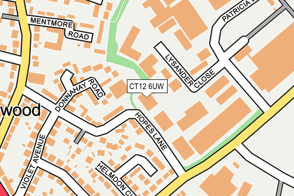
CT12 6UW is located in the Northwood electoral ward, within the local authority district of Thanet and the English Parliamentary constituency of South Thanet. The Sub Integrated Care Board (ICB) Location is NHS Kent and Medway ICB - 91Q and the police force is Kent. This postcode has been in use since January 1980.


GetTheData
Source: OS OpenMap – Local (Ordnance Survey)
Source: OS VectorMap District (Ordnance Survey)
Licence: Open Government Licence (requires attribution)
| Easting | 637324 |
| Northing | 167123 |
| Latitude | 51.353585 |
| Longitude | 1.407071 |
GetTheData
Source: Open Postcode Geo
Licence: Open Government Licence
| Country | England |
| Postcode District | CT12 |
| ➜ CT12 open data dashboard ➜ See where CT12 is on a map ➜ Where is Ramsgate? | |
GetTheData
Source: Land Registry Price Paid Data
Licence: Open Government Licence
Elevation or altitude of CT12 6UW as distance above sea level:
| Metres | Feet | |
|---|---|---|
| Elevation | 50m | 164ft |
Elevation is measured from the approximate centre of the postcode, to the nearest point on an OS contour line from OS Terrain 50, which has contour spacing of ten vertical metres.
➜ How high above sea level am I? Find the elevation of your current position using your device's GPS.
GetTheData
Source: Open Postcode Elevation
Licence: Open Government Licence
| Ward | Northwood |
| Constituency | South Thanet |
GetTheData
Source: ONS Postcode Database
Licence: Open Government Licence
| December 2023 | Violence and sexual offences | On or near Northwood Road | 260m |
| December 2023 | Criminal damage and arson | On or near Northwood Road | 260m |
| August 2023 | Violence and sexual offences | On or near Northwood Road | 260m |
| ➜ Get more crime data in our Crime section | |||
GetTheData
Source: data.police.uk
Licence: Open Government Licence
| Marrose Avenue (Northwood Road) | Northwood | 254m |
| Marrose Avenue (Northwood Road) | Northwood | 272m |
| Hopes Lane (Northwood Road) | Northwood | 286m |
| Vincent Close (Northwood Road) | Westwood | 353m |
| Hare And Hounds (Margate Road) | Northwood | 363m |
| Ramsgate Station | 1.4km |
| Dumpton Park Station | 1.6km |
| Broadstairs Station | 2km |
GetTheData
Source: NaPTAN
Licence: Open Government Licence
GetTheData
Source: ONS Postcode Database
Licence: Open Government Licence


➜ Get more ratings from the Food Standards Agency
GetTheData
Source: Food Standards Agency
Licence: FSA terms & conditions
| Last Collection | |||
|---|---|---|---|
| Location | Mon-Fri | Sat | Distance |
| Pysons Road | 17:00 | 12:00 | 307m |
| Northwood Post Office | 17:00 | 11:30 | 357m |
| The Silvers | 16:00 | 11:30 | 441m |
GetTheData
Source: Dracos
Licence: Creative Commons Attribution-ShareAlike
| Facility | Distance |
|---|---|
| Foreland Fields School Newlands Lane, Ramsgate Sports Hall, Outdoor Tennis Courts | 404m |
| Dame Janet Primary Academy Newington Road, Ramsgate Grass Pitches | 549m |
| The Royal Harbour Academy (Lower Site) Newlands Lane, Ramsgate Sports Hall, Grass Pitches, Studio | 607m |
GetTheData
Source: Active Places
Licence: Open Government Licence
| School | Phase of Education | Distance |
|---|---|---|
| Foreland Fields School Newlands Lane, Ramsgate, CT12 6RH | Not applicable | 377m |
| The Royal Harbour Academy Newlands Lane, Ramsgate, CT12 6RH | Secondary | 607m |
| Dame Janet Primary Academy Newington Road, Ramsgate, CT12 6QY | Primary | 698m |
GetTheData
Source: Edubase
Licence: Open Government Licence
The below table lists the International Territorial Level (ITL) codes (formerly Nomenclature of Territorial Units for Statistics (NUTS) codes) and Local Administrative Units (LAU) codes for CT12 6UW:
| ITL 1 Code | Name |
|---|---|
| TLJ | South East (England) |
| ITL 2 Code | Name |
| TLJ4 | Kent |
| ITL 3 Code | Name |
| TLJ44 | East Kent |
| LAU 1 Code | Name |
| E07000114 | Thanet |
GetTheData
Source: ONS Postcode Directory
Licence: Open Government Licence
The below table lists the Census Output Area (OA), Lower Layer Super Output Area (LSOA), and Middle Layer Super Output Area (MSOA) for CT12 6UW:
| Code | Name | |
|---|---|---|
| OA | E00125302 | |
| LSOA | E01024686 | Thanet 011A |
| MSOA | E02005142 | Thanet 011 |
GetTheData
Source: ONS Postcode Directory
Licence: Open Government Licence
| CT10 2YJ | Lysander Close | 64m |
| CT12 6RN | Hopes Lane | 112m |
| CT12 6RW | Donnahay Road | 139m |
| CT12 6TT | Helmdon Close | 151m |
| CT12 6UX | Mentmore Road | 160m |
| CT12 6TU | Pysons Road | 184m |
| CT12 6RP | Hopes Lane | 200m |
| CT12 6TL | Dorothy Drive | 216m |
| CT12 6TJ | Violet Avenue | 234m |
| CT10 2NB | Vincent Close | 242m |
GetTheData
Source: Open Postcode Geo; Land Registry Price Paid Data
Licence: Open Government Licence