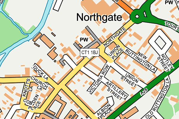
CT1 1BJ is located in the Northgate electoral ward, within the local authority district of Canterbury and the English Parliamentary constituency of Canterbury. The Sub Integrated Care Board (ICB) Location is NHS Kent and Medway ICB - 91Q and the police force is Kent. This postcode has been in use since December 1995.


GetTheData
Source: OS OpenMap – Local (Ordnance Survey)
Source: OS VectorMap District (Ordnance Survey)
Licence: Open Government Licence (requires attribution)
| Easting | 615227 |
| Northing | 158291 |
| Latitude | 51.283079 |
| Longitude | 1.084905 |
GetTheData
Source: Open Postcode Geo
Licence: Open Government Licence
| Country | England |
| Postcode District | CT1 |
| ➜ CT1 open data dashboard ➜ See where CT1 is on a map ➜ Where is Canterbury? | |
GetTheData
Source: Land Registry Price Paid Data
Licence: Open Government Licence
Elevation or altitude of CT1 1BJ as distance above sea level:
| Metres | Feet | |
|---|---|---|
| Elevation | 10m | 33ft |
Elevation is measured from the approximate centre of the postcode, to the nearest point on an OS contour line from OS Terrain 50, which has contour spacing of ten vertical metres.
➜ How high above sea level am I? Find the elevation of your current position using your device's GPS.
GetTheData
Source: Open Postcode Elevation
Licence: Open Government Licence
| Ward | Northgate |
| Constituency | Canterbury |
GetTheData
Source: ONS Postcode Database
Licence: Open Government Licence
| January 2024 | Violence and sexual offences | On or near Victoria Row | 64m |
| January 2024 | Violence and sexual offences | On or near Havelock Street | 319m |
| January 2024 | Violence and sexual offences | On or near Havelock Street | 319m |
| ➜ Get more crime data in our Crime section | |||
GetTheData
Source: data.police.uk
Licence: Open Government Licence
| St. Thomas' School (Military Road) | Northgate | 187m |
| St. Thomas' School (Military Road) | Northgate | 204m |
| Sainsburys (Kingsmead Road) | Northgate | 233m |
| Kingsmead Roundabout (Sturry Road) | Northgate | 257m |
| Kingsmead Roundabout (Sturry Road) | Northgate | 268m |
| Canterbury West Station | 0.7km |
| Canterbury East Station | 1.2km |
| Sturry Station | 3.3km |
GetTheData
Source: NaPTAN
Licence: Open Government Licence
GetTheData
Source: ONS Postcode Database
Licence: Open Government Licence


➜ Get more ratings from the Food Standards Agency
GetTheData
Source: Food Standards Agency
Licence: FSA terms & conditions
| Last Collection | |||
|---|---|---|---|
| Location | Mon-Fri | Sat | Distance |
| Northgate Post Office | 19:00 | 12:30 | 102m |
| Sainsburys | 18:00 | 10:30 | 166m |
| Kings School | 18:45 | 12:30 | 244m |
GetTheData
Source: Dracos
Licence: Creative Commons Attribution-ShareAlike
| Facility | Distance |
|---|---|
| St Johns Church Of England Primary School St. Johns Place, Canterbury Grass Pitches | 159m |
| Kingsmead Leisure Centre Kingsmead Road, Canterbury Sports Hall, Swimming Pool, Health and Fitness Gym, Studio | 333m |
| The Kings School Recreation Centre St. Stephens Road, Canterbury Sports Hall, Swimming Pool, Health and Fitness Gym, Artificial Grass Pitch, Studio, Squash Courts, Outdoor Tennis Courts | 458m |
GetTheData
Source: Active Places
Licence: Open Government Licence
| School | Phase of Education | Distance |
|---|---|---|
| St Johns Church of England Primary School St John's Place, Northgate, Canterbury, CT1 1BD | Primary | 175m |
| St Thomas' Catholic Primary School, Canterbury 99 Military Road, Canterbury, CT1 1NE | Primary | 225m |
| The King's School Canterbury 25 The Precincts, Canterbury, CT1 2ES | Not applicable | 237m |
GetTheData
Source: Edubase
Licence: Open Government Licence
The below table lists the International Territorial Level (ITL) codes (formerly Nomenclature of Territorial Units for Statistics (NUTS) codes) and Local Administrative Units (LAU) codes for CT1 1BJ:
| ITL 1 Code | Name |
|---|---|
| TLJ | South East (England) |
| ITL 2 Code | Name |
| TLJ4 | Kent |
| ITL 3 Code | Name |
| TLJ44 | East Kent |
| LAU 1 Code | Name |
| E07000106 | Canterbury |
GetTheData
Source: ONS Postcode Directory
Licence: Open Government Licence
The below table lists the Census Output Area (OA), Lower Layer Super Output Area (LSOA), and Middle Layer Super Output Area (MSOA) for CT1 1BJ:
| Code | Name | |
|---|---|---|
| OA | E00122317 | |
| LSOA | E01024093 | Canterbury 014E |
| MSOA | E02005023 | Canterbury 014 |
GetTheData
Source: ONS Postcode Directory
Licence: Open Government Licence
| CT1 1BE | Northgate | 19m |
| CT1 1BD | St Johns Place | 70m |
| CT1 1BA | Northgate | 79m |
| CT1 1LF | Artillery Gardens | 80m |
| CT1 1GZ | Victoria Yard | 84m |
| CT1 1RB | Kings Mews | 91m |
| CT1 1BL | Northgate | 95m |
| CT1 1BH | Northgate | 100m |
| CT1 1BB | Northgate | 112m |
| CT1 1LE | Victoria Row | 120m |
GetTheData
Source: Open Postcode Geo; Land Registry Price Paid Data
Licence: Open Government Licence