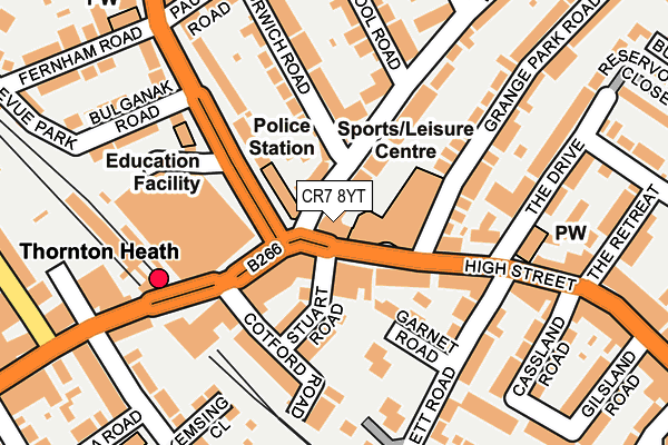
CR7 8YT is located in the Thornton Heath electoral ward, within the London borough of Croydon and the English Parliamentary constituency of Croydon North. The Sub Integrated Care Board (ICB) Location is NHS South West London ICB - 36L and the police force is Metropolitan Police. This postcode has been in use since February 1990.


GetTheData
Source: OS OpenMap – Local (Ordnance Survey)
Source: OS VectorMap District (Ordnance Survey)
Licence: Open Government Licence (requires attribution)
| Easting | 532440 |
| Northing | 168468 |
| Latitude | 51.399792 |
| Longitude | -0.097507 |
GetTheData
Source: Open Postcode Geo
Licence: Open Government Licence
| Country | England |
| Postcode District | CR7 |
| ➜ CR7 open data dashboard ➜ See where CR7 is on a map ➜ Where is London? | |
GetTheData
Source: Land Registry Price Paid Data
Licence: Open Government Licence
Elevation or altitude of CR7 8YT as distance above sea level:
| Metres | Feet | |
|---|---|---|
| Elevation | 50m | 164ft |
Elevation is measured from the approximate centre of the postcode, to the nearest point on an OS contour line from OS Terrain 50, which has contour spacing of ten vertical metres.
➜ How high above sea level am I? Find the elevation of your current position using your device's GPS.
GetTheData
Source: Open Postcode Elevation
Licence: Open Government Licence
| Ward | Thornton Heath |
| Constituency | Croydon North |
GetTheData
Source: ONS Postcode Database
Licence: Open Government Licence
| October 2023 | Vehicle crime | On or near Heath Road | 379m |
| September 2023 | Other theft | On or near Parking Area | 183m |
| September 2023 | Violence and sexual offences | On or near Heath Road | 379m |
| ➜ Get more crime data in our Crime section | |||
GetTheData
Source: data.police.uk
Licence: Open Government Licence
| Thornton Heath Clock Tower (Thornton Heath High Street) | Thornton Heath | 91m |
| Thornton Heath Clock Tower (Parchmore Road) | Thornton Heath | 99m |
| Parchmore Road | Thornton Heath | 123m |
| Thornton Heath Clock Tower | Thornton Heath | 124m |
| Thornton Heath (Brigstock Road) | Thornton Heath | 193m |
| Thornton Heath Station | 0.2km |
| Selhurst Station | 1.1km |
| Norwood Junction Station | 1.6km |
GetTheData
Source: NaPTAN
Licence: Open Government Licence
GetTheData
Source: ONS Postcode Database
Licence: Open Government Licence


➜ Get more ratings from the Food Standards Agency
GetTheData
Source: Food Standards Agency
Licence: FSA terms & conditions
| Last Collection | |||
|---|---|---|---|
| Location | Mon-Fri | Sat | Distance |
| Woodville Road | 16:45 | 12:00 | 87m |
| St Pauls Road(Parchmore Crt) | 16:30 | 12:00 | 181m |
| Brigstock Road(17) Tso | 18:00 | 12:00 | 287m |
GetTheData
Source: Dracos
Licence: Creative Commons Attribution-ShareAlike
| Facility | Distance |
|---|---|
| Thornton Heath Leisure Centre High Street, Thornton Heath Sports Hall, Swimming Pool, Health and Fitness Gym, Studio | 86m |
| Energie Fitness (Thornton Heath) Brigstock Road, Brigstock Road, Thornton Heath Health and Fitness Gym | 198m |
| Whitehorse Manor School Whitehorse Road, Thornton Heath Grass Pitches | 559m |
GetTheData
Source: Active Places
Licence: Open Government Licence
| School | Phase of Education | Distance |
|---|---|---|
| Thornton Heath Nursery School 51 Pridham Road, Thornton Heath, CR7 8RS | Nursery | 377m |
| Beulah Infants' School Furze Road, Thornton Heath, London, CR7 8NJ | Primary | 461m |
| Beulah Junior School Beulah Road, Thornton Heath, CR7 8JF | Primary | 514m |
GetTheData
Source: Edubase
Licence: Open Government Licence
The below table lists the International Territorial Level (ITL) codes (formerly Nomenclature of Territorial Units for Statistics (NUTS) codes) and Local Administrative Units (LAU) codes for CR7 8YT:
| ITL 1 Code | Name |
|---|---|
| TLI | London |
| ITL 2 Code | Name |
| TLI6 | Outer London - South |
| ITL 3 Code | Name |
| TLI62 | Croydon |
| LAU 1 Code | Name |
| E09000008 | Croydon |
GetTheData
Source: ONS Postcode Directory
Licence: Open Government Licence
The below table lists the Census Output Area (OA), Lower Layer Super Output Area (LSOA), and Middle Layer Super Output Area (MSOA) for CR7 8YT:
| Code | Name | |
|---|---|---|
| OA | E00005744 | |
| LSOA | E01001155 | Croydon 010E |
| MSOA | E02000203 | Croydon 010 |
GetTheData
Source: ONS Postcode Directory
Licence: Open Government Licence
| CR7 8LH | Woodville Road | 27m |
| CR7 8LG | Woodville Road | 48m |
| CR7 8LU | Parchmore Road | 88m |
| CR7 8NA | Norwich Road | 89m |
| CR7 8LS | Liverpool Road | 95m |
| CR7 8RZ | High Street | 126m |
| CR7 8QE | Grange Park Road | 139m |
| CR7 8LF | High Street | 144m |
| CR7 8RY | High Street | 147m |
| CR7 8QA | Grange Park Road | 153m |
GetTheData
Source: Open Postcode Geo; Land Registry Price Paid Data
Licence: Open Government Licence