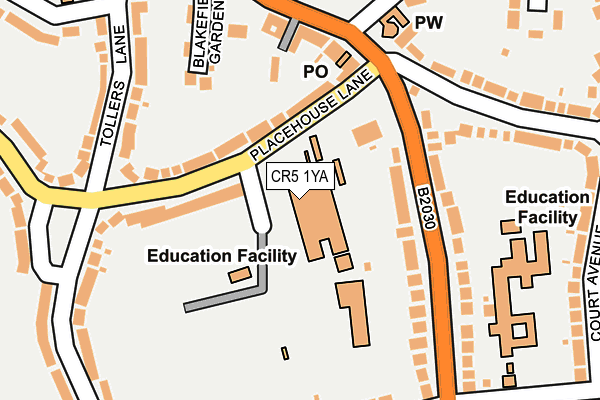
CR5 1YA is located in the Old Coulsdon electoral ward, within the London borough of Croydon and the English Parliamentary constituency of Croydon South. The Sub Integrated Care Board (ICB) Location is NHS South West London ICB - 36L and the police force is Metropolitan Police. This postcode has been in use since February 1990.


GetTheData
Source: OS OpenMap – Local (Ordnance Survey)
Source: OS VectorMap District (Ordnance Survey)
Licence: Open Government Licence (requires attribution)
| Easting | 531095 |
| Northing | 157960 |
| Latitude | 51.305670 |
| Longitude | -0.120724 |
GetTheData
Source: Open Postcode Geo
Licence: Open Government Licence
| Country | England |
| Postcode District | CR5 |
➜ See where CR5 is on a map ➜ Where is Coulsdon? | |
GetTheData
Source: Land Registry Price Paid Data
Licence: Open Government Licence
Elevation or altitude of CR5 1YA as distance above sea level:
| Metres | Feet | |
|---|---|---|
| Elevation | 160m | 525ft |
Elevation is measured from the approximate centre of the postcode, to the nearest point on an OS contour line from OS Terrain 50, which has contour spacing of ten vertical metres.
➜ How high above sea level am I? Find the elevation of your current position using your device's GPS.
GetTheData
Source: Open Postcode Elevation
Licence: Open Government Licence
| Ward | Old Coulsdon |
| Constituency | Croydon South |
GetTheData
Source: ONS Postcode Database
Licence: Open Government Licence
| Old Coulsdon Tudor Rose (Placehouse Lane) | Old Coulsdon | 105m |
| The Crossways (Coulsdon Road) | Old Coulsdon | 170m |
| Old Coulsdon Tudor Rose (Coulsdon Road) | Old Coulsdon | 181m |
| Old Coulsdon Tudor Rose | Old Coulsdon | 191m |
| Tollers Lane Placehouse Lane | Old Coulsdon | 219m |
| Coulsdon South Station | 1.6km |
| Coulsdon Town Station | 2.1km |
| Kenley Station | 2.5km |
GetTheData
Source: NaPTAN
Licence: Open Government Licence
GetTheData
Source: ONS Postcode Database
Licence: Open Government Licence


➜ Get more ratings from the Food Standards Agency
GetTheData
Source: Food Standards Agency
Licence: FSA terms & conditions
| Last Collection | |||
|---|---|---|---|
| Location | Mon-Fri | Sat | Distance |
| Old Coulsdon Tso | 19:00 | 12:00 | 155m |
| Coulsdon Road (124) | 19:15 | 12:00 | 158m |
| Keston Avenue(30) | 16:00 | 12:00 | 378m |
GetTheData
Source: Dracos
Licence: Creative Commons Attribution-ShareAlike
The below table lists the International Territorial Level (ITL) codes (formerly Nomenclature of Territorial Units for Statistics (NUTS) codes) and Local Administrative Units (LAU) codes for CR5 1YA:
| ITL 1 Code | Name |
|---|---|
| TLI | London |
| ITL 2 Code | Name |
| TLI6 | Outer London - South |
| ITL 3 Code | Name |
| TLI62 | Croydon |
| LAU 1 Code | Name |
| E09000008 | Croydon |
GetTheData
Source: ONS Postcode Directory
Licence: Open Government Licence
The below table lists the Census Output Area (OA), Lower Layer Super Output Area (LSOA), and Middle Layer Super Output Area (MSOA) for CR5 1YA:
| Code | Name | |
|---|---|---|
| OA | E00005078 | |
| LSOA | E01001020 | Croydon 044C |
| MSOA | E02000237 | Croydon 044 |
GetTheData
Source: ONS Postcode Directory
Licence: Open Government Licence
| CR5 1LA | Placehouse Lane | 95m |
| CR5 1EH | Coulsdon Road | 141m |
| CR5 1EB | Coulsdon Road | 147m |
| CR5 1EA | Coulsdon Road | 171m |
| CR5 1AY | Blakefield Gardens | 192m |
| CR5 1BE | Tollers Lane | 197m |
| CR5 1LB | The Crossways | 221m |
| CR5 1BA | Tollers Lane | 226m |
| CR5 1HF | Court Avenue | 228m |
| CR5 1HA | Church Cottages | 230m |
GetTheData
Source: Open Postcode Geo; Land Registry Price Paid Data
Licence: Open Government Licence