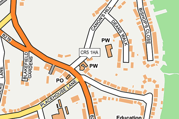
CR5 1HA lies on Church Cottages in Coulsdon. CR5 1HA is located in the Old Coulsdon electoral ward, within the London borough of Croydon and the English Parliamentary constituency of Croydon South. The Sub Integrated Care Board (ICB) Location is NHS South West London ICB - 36L and the police force is Metropolitan Police. This postcode has been in use since July 1990.


GetTheData
Source: OS OpenMap – Local (Ordnance Survey)
Source: OS VectorMap District (Ordnance Survey)
Licence: Open Government Licence (requires attribution)
| Easting | 531210 |
| Northing | 158159 |
| Latitude | 51.307430 |
| Longitude | -0.118975 |
GetTheData
Source: Open Postcode Geo
Licence: Open Government Licence
| Street | Church Cottages |
| Town/City | Coulsdon |
| Country | England |
| Postcode District | CR5 |
➜ See where CR5 is on a map ➜ Where is Coulsdon? | |
GetTheData
Source: Land Registry Price Paid Data
Licence: Open Government Licence
Elevation or altitude of CR5 1HA as distance above sea level:
| Metres | Feet | |
|---|---|---|
| Elevation | 160m | 525ft |
Elevation is measured from the approximate centre of the postcode, to the nearest point on an OS contour line from OS Terrain 50, which has contour spacing of ten vertical metres.
➜ How high above sea level am I? Find the elevation of your current position using your device's GPS.
GetTheData
Source: Open Postcode Elevation
Licence: Open Government Licence
| Ward | Old Coulsdon |
| Constituency | Croydon South |
GetTheData
Source: ONS Postcode Database
Licence: Open Government Licence
| Old Coulsdon Tudor Rose | Old Coulsdon | 101m |
| Old Coulsdon Tudor Rose (Coulsdon Road) | Old Coulsdon | 118m |
| Old Coulsdon Tudor Rose (Placehouse Lane) | Old Coulsdon | 125m |
| The Crossways (Coulsdon Road) | Old Coulsdon | 302m |
| The Crossways (Coulsdon Road) | Old Coulsdon | 366m |
| Coulsdon South Station | 1.6km |
| Coulsdon Town Station | 2km |
| Kenley Station | 2.3km |
GetTheData
Source: NaPTAN
Licence: Open Government Licence
| Percentage of properties with Next Generation Access | 100.0% |
| Percentage of properties with Superfast Broadband | 100.0% |
| Percentage of properties with Ultrafast Broadband | 100.0% |
| Percentage of properties with Full Fibre Broadband | 0.0% |
Superfast Broadband is between 30Mbps and 300Mbps
Ultrafast Broadband is > 300Mbps
| Percentage of properties unable to receive 2Mbps | 0.0% |
| Percentage of properties unable to receive 5Mbps | 0.0% |
| Percentage of properties unable to receive 10Mbps | 0.0% |
| Percentage of properties unable to receive 30Mbps | 0.0% |
GetTheData
Source: Ofcom
Licence: Ofcom Terms of Use (requires attribution)
GetTheData
Source: ONS Postcode Database
Licence: Open Government Licence


➜ Get more ratings from the Food Standards Agency
GetTheData
Source: Food Standards Agency
Licence: FSA terms & conditions
| Last Collection | |||
|---|---|---|---|
| Location | Mon-Fri | Sat | Distance |
| Coulsdon Road (124) | 19:15 | 12:00 | 72m |
| Old Coulsdon Tso | 19:00 | 12:00 | 79m |
| Keston Avenue(30) | 16:00 | 12:00 | 436m |
GetTheData
Source: Dracos
Licence: Creative Commons Attribution-ShareAlike
The below table lists the International Territorial Level (ITL) codes (formerly Nomenclature of Territorial Units for Statistics (NUTS) codes) and Local Administrative Units (LAU) codes for CR5 1HA:
| ITL 1 Code | Name |
|---|---|
| TLI | London |
| ITL 2 Code | Name |
| TLI6 | Outer London - South |
| ITL 3 Code | Name |
| TLI62 | Croydon |
| LAU 1 Code | Name |
| E09000008 | Croydon |
GetTheData
Source: ONS Postcode Directory
Licence: Open Government Licence
The below table lists the Census Output Area (OA), Lower Layer Super Output Area (LSOA), and Middle Layer Super Output Area (MSOA) for CR5 1HA:
| Code | Name | |
|---|---|---|
| OA | E00005076 | |
| LSOA | E01001018 | Croydon 044A |
| MSOA | E02000237 | Croydon 044 |
GetTheData
Source: ONS Postcode Directory
Licence: Open Government Licence
| CR5 1HR | Deans Walk | 104m |
| CR5 1HF | Court Avenue | 122m |
| CR5 1EA | Coulsdon Road | 123m |
| CR5 1EH | Coulsdon Road | 157m |
| CR5 1HG | Court Avenue | 178m |
| CR5 1HH | Bishops Close | 199m |
| CR5 1AY | Blakefield Gardens | 233m |
| CR5 1HQ | Tudor Close | 242m |
| CR5 1LA | Placehouse Lane | 248m |
| CR5 1HB | Canons Hill | 285m |
GetTheData
Source: Open Postcode Geo; Land Registry Price Paid Data
Licence: Open Government Licence