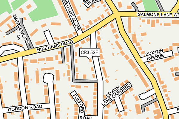
CR3 5SF is located in the Portley electoral ward, within the local authority district of Tandridge and the English Parliamentary constituency of East Surrey. The Sub Integrated Care Board (ICB) Location is NHS Surrey Heartlands ICB - 92A and the police force is Surrey. This postcode has been in use since January 1980.


GetTheData
Source: OS OpenMap – Local (Ordnance Survey)
Source: OS VectorMap District (Ordnance Survey)
Licence: Open Government Licence (requires attribution)
| Easting | 532973 |
| Northing | 156959 |
| Latitude | 51.296239 |
| Longitude | -0.094171 |
GetTheData
Source: Open Postcode Geo
Licence: Open Government Licence
| Country | England |
| Postcode District | CR3 |
| ➜ CR3 open data dashboard ➜ See where CR3 is on a map ➜ Where is Caterham? | |
GetTheData
Source: Land Registry Price Paid Data
Licence: Open Government Licence
Elevation or altitude of CR3 5SF as distance above sea level:
| Metres | Feet | |
|---|---|---|
| Elevation | 170m | 558ft |
Elevation is measured from the approximate centre of the postcode, to the nearest point on an OS contour line from OS Terrain 50, which has contour spacing of ten vertical metres.
➜ How high above sea level am I? Find the elevation of your current position using your device's GPS.
GetTheData
Source: Open Postcode Elevation
Licence: Open Government Licence
| Ward | Portley |
| Constituency | East Surrey |
GetTheData
Source: ONS Postcode Database
Licence: Open Government Licence
| July 2023 | Violence and sexual offences | On or near Fulford Road | 162m |
| June 2023 | Public order | On or near Fulford Road | 162m |
| November 2022 | Violence and sexual offences | On or near Fulford Road | 162m |
| ➜ Get more crime data in our Crime section | |||
GetTheData
Source: data.police.uk
Licence: Open Government Licence
| Ninehams Road (Buxton Lane) | Caterham | 145m |
| Ninehams Road (Buxton Lane) | Caterham | 150m |
| Portley Lane (Buxton Lane) | Caterham | 271m |
| Portley Lane (Buxton Lane) | Caterham | 335m |
| Salmons Lane Green (Salmons Lane West) | Caterham | 363m |
| Whyteleafe South Station | 1.4km |
| Upper Warlingham Station | 1.8km |
| Whyteleafe Station | 1.8km |
GetTheData
Source: NaPTAN
Licence: Open Government Licence
| Percentage of properties with Next Generation Access | 100.0% |
| Percentage of properties with Superfast Broadband | 100.0% |
| Percentage of properties with Ultrafast Broadband | 100.0% |
| Percentage of properties with Full Fibre Broadband | 0.0% |
Superfast Broadband is between 30Mbps and 300Mbps
Ultrafast Broadband is > 300Mbps
| Percentage of properties unable to receive 2Mbps | 0.0% |
| Percentage of properties unable to receive 5Mbps | 0.0% |
| Percentage of properties unable to receive 10Mbps | 0.0% |
| Percentage of properties unable to receive 30Mbps | 0.0% |
GetTheData
Source: Ofcom
Licence: Ofcom Terms of Use (requires attribution)
GetTheData
Source: ONS Postcode Database
Licence: Open Government Licence


➜ Get more ratings from the Food Standards Agency
GetTheData
Source: Food Standards Agency
Licence: FSA terms & conditions
| Last Collection | |||
|---|---|---|---|
| Location | Mon-Fri | Sat | Distance |
| Buxton Lane(21a) | 16:15 | 12:00 | 417m |
| Chaldon Common Road (Opp40a) | 16:30 | 12:00 | 651m |
| Coulsdon Road (188) | 17:30 | 12:00 | 673m |
GetTheData
Source: Dracos
Licence: Creative Commons Attribution-ShareAlike
| Facility | Distance |
|---|---|
| Audley Primary School Whyteleafe Road, Caterham Swimming Pool, Sports Hall | 530m |
| St Francis Rc School Whyteleafe Road, Caterham Grass Pitches | 629m |
| De Stafford School Burntwood Lane, Caterham Grass Pitches, Sports Hall | 746m |
GetTheData
Source: Active Places
Licence: Open Government Licence
| School | Phase of Education | Distance |
|---|---|---|
| OneSchool Global Kenley Campus Victor Beamish Avenue, Caterham, CR3 5FX | Not applicable | 410m |
| Audley Primary School Whyteleafe Road, Caterham, CR3 5ED | Primary | 537m |
| St Francis Catholic Primary School Whyteleafe Road, Caterham, CR3 5ED | Primary | 629m |
GetTheData
Source: Edubase
Licence: Open Government Licence
The below table lists the International Territorial Level (ITL) codes (formerly Nomenclature of Territorial Units for Statistics (NUTS) codes) and Local Administrative Units (LAU) codes for CR3 5SF:
| ITL 1 Code | Name |
|---|---|
| TLJ | South East (England) |
| ITL 2 Code | Name |
| TLJ2 | Surrey, East and West Sussex |
| ITL 3 Code | Name |
| TLJ26 | East Surrey |
| LAU 1 Code | Name |
| E07000215 | Tandridge |
GetTheData
Source: ONS Postcode Directory
Licence: Open Government Licence
The below table lists the Census Output Area (OA), Lower Layer Super Output Area (LSOA), and Middle Layer Super Output Area (MSOA) for CR3 5SF:
| Code | Name | |
|---|---|---|
| OA | E00157272 | |
| LSOA | E01030844 | Tandridge 003A |
| MSOA | E02006430 | Tandridge 003 |
GetTheData
Source: ONS Postcode Directory
Licence: Open Government Licence
| CR3 5SH | Foxon Lane | 39m |
| CR3 5SL | Reid Avenue | 54m |
| CR3 5LD | Ninehams Road | 64m |
| CR3 5LL | Ninehams Road | 110m |
| CR3 5SE | Foxon Lane | 118m |
| CR3 5LH | Ninehams Road | 125m |
| CR3 5LG | Ninehams Road | 132m |
| CR3 5SN | Foxon Lane Gardens | 170m |
| CR3 5HN | Buxton Lane | 177m |
| CR3 5SQ | Fulford Road | 185m |
GetTheData
Source: Open Postcode Geo; Land Registry Price Paid Data
Licence: Open Government Licence