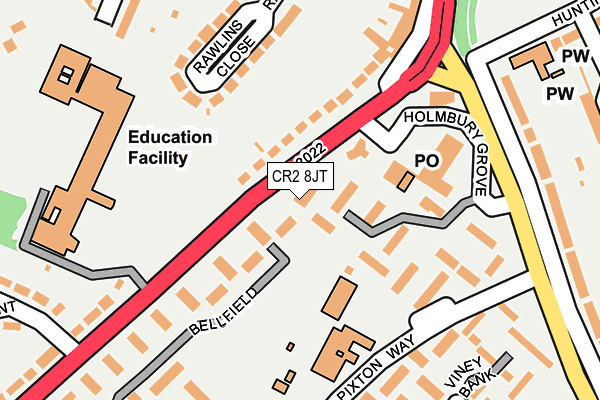
CR2 8JT lies on Selsdon Park Road in South Croydon. CR2 8JT is located in the Selsdon Vale & Forestdale electoral ward, within the London borough of Croydon and the English Parliamentary constituency of Croydon Central. The Sub Integrated Care Board (ICB) Location is NHS South West London ICB - 36L and the police force is Metropolitan Police. This postcode has been in use since January 1980.


GetTheData
Source: OS OpenMap – Local (Ordnance Survey)
Source: OS VectorMap District (Ordnance Survey)
Licence: Open Government Licence (requires attribution)
| Easting | 536588 |
| Northing | 163110 |
| Latitude | 51.350659 |
| Longitude | -0.039972 |
GetTheData
Source: Open Postcode Geo
Licence: Open Government Licence
| Street | Selsdon Park Road |
| Town/City | South Croydon |
| Country | England |
| Postcode District | CR2 |
| ➜ CR2 open data dashboard ➜ See where CR2 is on a map ➜ Where is London? | |
GetTheData
Source: Land Registry Price Paid Data
Licence: Open Government Licence
Elevation or altitude of CR2 8JT as distance above sea level:
| Metres | Feet | |
|---|---|---|
| Elevation | 90m | 295ft |
Elevation is measured from the approximate centre of the postcode, to the nearest point on an OS contour line from OS Terrain 50, which has contour spacing of ten vertical metres.
➜ How high above sea level am I? Find the elevation of your current position using your device's GPS.
GetTheData
Source: Open Postcode Elevation
Licence: Open Government Licence
| Ward | Selsdon Vale & Forestdale |
| Constituency | Croydon Central |
GetTheData
Source: ONS Postcode Database
Licence: Open Government Licence
| January 2024 | Criminal damage and arson | On or near Parking Area | 132m |
| January 2024 | Public order | On or near Bellfield | 147m |
| January 2024 | Criminal damage and arson | On or near Holmbury Grove | 163m |
| ➜ Get more crime data in our Crime section | |||
GetTheData
Source: data.police.uk
Licence: Open Government Licence
| Featherbed Lane (Selsdon Park Road) | Forestdale | 75m |
| Yew Tree Way (Featherbed Lane) | Forestdale | 201m |
| John Ruskin College (Selsdon Park Road) | Forestdale | 240m |
| John Ruskin College (Selsdon Park Road) | Forestdale | 261m |
| Gravel Hill (Cr2) | Forestdale | 278m |
| Gravel Hill Tram Stop (Gravel Hill) | Forestdale | 485m |
| Addington Village Tram Stop (Kent Gate Way) | Addington | 803m |
| Fieldway Tram Stop (Lodge Lane) | Forestdale | 1,080m |
| King Henry's Drive Tram Stop (Parkway) | New Addington | 1,494m |
| Coombe Lane Tram Stop (Coombe Lane) | Upper Shirley | 1,699m |
| Sanderstead Station | 3.7km |
| West Wickham Station | 3.8km |
| South Croydon Station | 4km |
GetTheData
Source: NaPTAN
Licence: Open Government Licence
GetTheData
Source: ONS Postcode Database
Licence: Open Government Licence


➜ Get more ratings from the Food Standards Agency
GetTheData
Source: Food Standards Agency
Licence: FSA terms & conditions
| Last Collection | |||
|---|---|---|---|
| Location | Mon-Fri | Sat | Distance |
| Forestdale Tso | 17:15 | 12:00 | 130m |
| Featherbed Lane (32) | 16:30 | 12:00 | 373m |
| Gravel Hill (26) | 17:15 | 12:00 | 391m |
GetTheData
Source: Dracos
Licence: Creative Commons Attribution-ShareAlike
| Facility | Distance |
|---|---|
| John Ruskin College Selsdon Park Road, South Croydon Health and Fitness Gym, Grass Pitches, Sports Hall | 208m |
| Gilbert Scott Primary School Farnborough Avenue, South Croydon Swimming Pool, Grass Pitches | 475m |
| Addington Palace Country Club (Closed) Gravel Hill, Croydon Health and Fitness Gym, Studio | 545m |
GetTheData
Source: Active Places
Licence: Open Government Licence
| School | Phase of Education | Distance |
|---|---|---|
| Forestdale Primary School Pixton Way, Croydon, CR0 9JE | Primary | 151m |
| Red Gates School Farnborough Avenue, South Croydon, CR2 8HD | Not applicable | 416m |
| Quest Primary School Farnborough Avenue, South Croydon, CR2 8HD | Primary | 475m |
GetTheData
Source: Edubase
Licence: Open Government Licence
The below table lists the International Territorial Level (ITL) codes (formerly Nomenclature of Territorial Units for Statistics (NUTS) codes) and Local Administrative Units (LAU) codes for CR2 8JT:
| ITL 1 Code | Name |
|---|---|
| TLI | London |
| ITL 2 Code | Name |
| TLI6 | Outer London - South |
| ITL 3 Code | Name |
| TLI62 | Croydon |
| LAU 1 Code | Name |
| E09000008 | Croydon |
GetTheData
Source: ONS Postcode Directory
Licence: Open Government Licence
The below table lists the Census Output Area (OA), Lower Layer Super Output Area (LSOA), and Middle Layer Super Output Area (MSOA) for CR2 8JT:
| Code | Name | |
|---|---|---|
| OA | E00005303 | |
| LSOA | E01001065 | Croydon 034E |
| MSOA | E02000227 | Croydon 034 |
GetTheData
Source: ONS Postcode Directory
Licence: Open Government Licence
| CR0 9JX | Bellfield | 54m |
| CR0 9AQ | Holmbury Grove | 67m |
| CR2 8JJ | Selsdon Park Road | 88m |
| CR0 9AR | Holmbury Grove | 129m |
| CR2 8JS | Rawlins Close | 150m |
| CR0 9AP | Holmbury Grove | 158m |
| CR0 9AN | Holmbury Grove | 179m |
| CR0 9JW | Bellfield | 181m |
| CR2 8JR | Rawlins Close | 190m |
| CR0 9JT | Viney Bank | 220m |
GetTheData
Source: Open Postcode Geo; Land Registry Price Paid Data
Licence: Open Government Licence