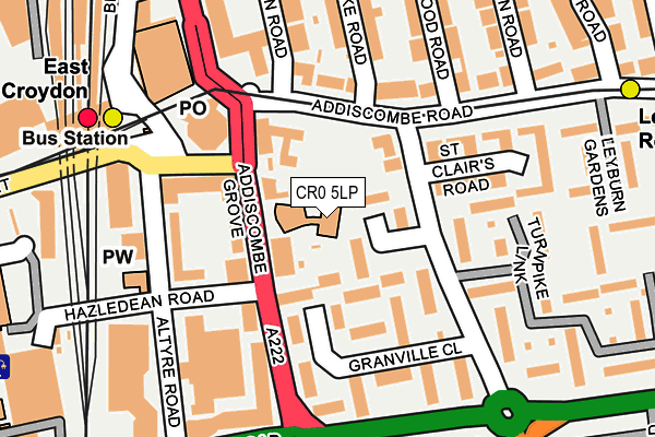
CR0 5LP is located in the Addiscombe West electoral ward, within the London borough of Croydon and the English Parliamentary constituency of Croydon Central. The Sub Integrated Care Board (ICB) Location is NHS South West London ICB - 36L and the police force is Metropolitan Police. This postcode has been in use since January 1980.


GetTheData
Source: OS OpenMap – Local (Ordnance Survey)
Source: OS VectorMap District (Ordnance Survey)
Licence: Open Government Licence (requires attribution)
| Easting | 533071 |
| Northing | 165637 |
| Latitude | 51.374203 |
| Longitude | -0.089527 |
GetTheData
Source: Open Postcode Geo
Licence: Open Government Licence
| Country | England |
| Postcode District | CR0 |
| ➜ CR0 open data dashboard ➜ See where CR0 is on a map ➜ Where is Croydon? | |
GetTheData
Source: Land Registry Price Paid Data
Licence: Open Government Licence
Elevation or altitude of CR0 5LP as distance above sea level:
| Metres | Feet | |
|---|---|---|
| Elevation | 70m | 230ft |
Elevation is measured from the approximate centre of the postcode, to the nearest point on an OS contour line from OS Terrain 50, which has contour spacing of ten vertical metres.
➜ How high above sea level am I? Find the elevation of your current position using your device's GPS.
GetTheData
Source: Open Postcode Elevation
Licence: Open Government Licence
| Ward | Addiscombe West |
| Constituency | Croydon Central |
GetTheData
Source: ONS Postcode Database
Licence: Open Government Licence
| January 2024 | Burglary | On or near Garrick Crescent | 62m |
| January 2024 | Criminal damage and arson | On or near Garrick Crescent | 62m |
| January 2024 | Anti-social behaviour | On or near Oval Road | 405m |
| ➜ Get more crime data in our Crime section | |||
GetTheData
Source: data.police.uk
Licence: Open Government Licence
| Garrick Crescent (Park Hill Road) | Croydon | 82m |
| Garrick Crescent (Park Hill Road) | Croydon | 99m |
| East Croydon Rail Station (East Croydon Bus Station) | Croydon | 156m |
| East Croydon Rail Station (East Croydon Bus Station) | Croydon | 158m |
| East Croydon Rail Station (East Croydon Bus Station) | Croydon | 174m |
| East Croydon Tram Stop (George Street) | Croydon | 214m |
| Lebanon Road Tram Stop (Addiscombe Road) | Addiscombe | 334m |
| Wellesley Road Tram Stop (Wellesley Road) | Croydon | 574m |
| George Street Tram Stop (George Street) | Croydon | 642m |
| Sandilands Tram Stop (Addiscombe Road) | Addiscombe | 805m |
| East Croydon Station | 0.3km |
| West Croydon Station | 1km |
| South Croydon Station | 1.3km |
GetTheData
Source: NaPTAN
Licence: Open Government Licence
Estimated total energy consumption in CR0 5LP by fuel type, 2015.
| Consumption (kWh) | 310,325 |
|---|---|
| Meter count | 26 |
| Mean (kWh/meter) | 11,936 |
| Median (kWh/meter) | 7,603 |
GetTheData
Source: Postcode level gas estimates: 2015 (experimental)
Source: Postcode level electricity estimates: 2015 (experimental)
Licence: Open Government Licence
GetTheData
Source: ONS Postcode Database
Licence: Open Government Licence


➜ Get more ratings from the Food Standards Agency
GetTheData
Source: Food Standards Agency
Licence: FSA terms & conditions
| Last Collection | |||
|---|---|---|---|
| Location | Mon-Fri | Sat | Distance |
| Park Hill Road (2) | 16:30 | 12:00 | 84m |
| Croydon Delivery Office | 18:45 | 12:30 | 193m |
| Fairfield Path (Alden Court) | 16:45 | 12:00 | 286m |
GetTheData
Source: Dracos
Licence: Creative Commons Attribution-ShareAlike
| Facility | Distance |
|---|---|
| H2o Leisure Club Altyre Road, Croydon Health and Fitness Gym, Swimming Pool, Squash Courts | 176m |
| Energie Fitness (Croydon) (Closed) Cherry Orchard Road, Croydon Health and Fitness Gym, Studio | 243m |
| Ark Oval Primary Academy Cherry Orchard Road, Croydon Grass Pitches | 417m |
GetTheData
Source: Active Places
Licence: Open Government Licence
| School | Phase of Education | Distance |
|---|---|---|
| Park Hill Infant School Stanhope Road, Croydon, CR0 5NS | Primary | 371m |
| Park Hill Junior School Stanhope Road, Croydon, CR0 5NS | Primary | 414m |
| Ark Oval Primary Academy 98 Cherry Orchard Road, Croydon, CR0 6BA | Primary | 417m |
GetTheData
Source: Edubase
Licence: Open Government Licence
The below table lists the International Territorial Level (ITL) codes (formerly Nomenclature of Territorial Units for Statistics (NUTS) codes) and Local Administrative Units (LAU) codes for CR0 5LP:
| ITL 1 Code | Name |
|---|---|
| TLI | London |
| ITL 2 Code | Name |
| TLI6 | Outer London - South |
| ITL 3 Code | Name |
| TLI62 | Croydon |
| LAU 1 Code | Name |
| E09000008 | Croydon |
GetTheData
Source: ONS Postcode Directory
Licence: Open Government Licence
The below table lists the Census Output Area (OA), Lower Layer Super Output Area (LSOA), and Middle Layer Super Output Area (MSOA) for CR0 5LP:
| Code | Name | |
|---|---|---|
| OA | E00005233 | |
| LSOA | E01001045 | Croydon 027C |
| MSOA | E02000220 | Croydon 027 |
GetTheData
Source: ONS Postcode Directory
Licence: Open Government Licence
| CR0 5PW | Garrick Crescent | 54m |
| CR0 5NA | Park Hill Road | 60m |
| CR0 5LR | Addiscombe Grove | 85m |
| CR0 5PZ | Granville Close | 102m |
| CR0 5LE | Altyre Road | 125m |
| CR0 5LF | Altyre Road | 125m |
| CR0 6SA | Addiscombe Road | 134m |
| CR0 5PY | Granville Close | 137m |
| CR0 6SB | Addiscombe Road | 142m |
| CR9 6LL | Addiscombe Road | 146m |
GetTheData
Source: Open Postcode Geo; Land Registry Price Paid Data
Licence: Open Government Licence