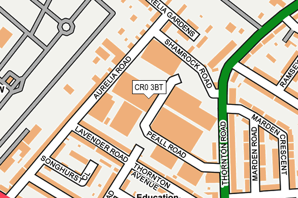
CR0 3BT is located in the West Thornton electoral ward, within the London borough of Croydon and the English Parliamentary constituency of Croydon North. The Sub Integrated Care Board (ICB) Location is NHS South West London ICB - 36L and the police force is Metropolitan Police. This postcode has been in use since August 1993.


GetTheData
Source: OS OpenMap – Local (Ordnance Survey)
Source: OS VectorMap District (Ordnance Survey)
Licence: Open Government Licence (requires attribution)
| Easting | 530691 |
| Northing | 167305 |
| Latitude | 51.389745 |
| Longitude | -0.123062 |
GetTheData
Source: Open Postcode Geo
Licence: Open Government Licence
| Country | England |
| Postcode District | CR0 |
| ➜ CR0 open data dashboard ➜ See where CR0 is on a map ➜ Where is London? | |
GetTheData
Source: Land Registry Price Paid Data
Licence: Open Government Licence
Elevation or altitude of CR0 3BT as distance above sea level:
| Metres | Feet | |
|---|---|---|
| Elevation | 40m | 131ft |
Elevation is measured from the approximate centre of the postcode, to the nearest point on an OS contour line from OS Terrain 50, which has contour spacing of ten vertical metres.
➜ How high above sea level am I? Find the elevation of your current position using your device's GPS.
GetTheData
Source: Open Postcode Elevation
Licence: Open Government Licence
| Ward | West Thornton |
| Constituency | Croydon North |
GetTheData
Source: ONS Postcode Database
Licence: Open Government Licence
| January 2024 | Burglary | On or near Songhurst Close | 220m |
| January 2024 | Violence and sexual offences | On or near Songhurst Close | 220m |
| January 2024 | Other theft | On or near Songhurst Close | 220m |
| ➜ Get more crime data in our Crime section | |||
GetTheData
Source: data.police.uk
Licence: Open Government Licence
| Peall Road | Broad Green | 160m |
| Peall Road | Broad Green | 182m |
| Croydon Crematorium (Thornton Road) | Broad Green | 237m |
| Brading Road (Mitcham Road) | Broad Green | 318m |
| Brading Road (Mitcham Road) | Broad Green | 335m |
| Therapia Lane Tram Stop (Off Alfriston Ave) | Broad Green | 612m |
| Ampere Way Tram Stop (Ampere Way) | Broad Green | 829m |
| Beddington Lane Tram Stop (Off Beddington Lane) | Beddington Corner | 1,329m |
| Waddon Marsh Tram Stop (Off Gurney Crescent) | Waddon | 1,453m |
| Thornton Heath Station | 1.9km |
| West Croydon Station | 1.9km |
| Norbury Station | 2.4km |
GetTheData
Source: NaPTAN
Licence: Open Government Licence
GetTheData
Source: ONS Postcode Database
Licence: Open Government Licence


➜ Get more ratings from the Food Standards Agency
GetTheData
Source: Food Standards Agency
Licence: FSA terms & conditions
| Last Collection | |||
|---|---|---|---|
| Location | Mon-Fri | Sat | Distance |
| Thornton Road(265) | 18:15 | 12:00 | 180m |
| The Parade (2) Tso | 17:30 | 12:00 | 341m |
| Thornton Road (78) | 16:30 | 12:00 | 499m |
GetTheData
Source: Dracos
Licence: Creative Commons Attribution-ShareAlike
| Facility | Distance |
|---|---|
| Afc Croydon Athletic Training Ground Mitcham Road, Croydon Grass Pitches | 462m |
| The Archbishop Lanfranc Academy Mitcham Road, Croydon Health and Fitness Gym, Artificial Grass Pitch, Grass Pitches, Sports Hall, Studio, Outdoor Tennis Courts | 545m |
| Gonville Academy Gonville Road, Thornton Heath Grass Pitches, Sports Hall | 577m |
GetTheData
Source: Active Places
Licence: Open Government Licence
| School | Phase of Education | Distance |
|---|---|---|
| West Thornton Primary School Rosecourt Road, Croydon, CR0 3BS | Primary | 267m |
| The Archbishop Lanfranc Academy Mitcham Road, Croydon, CR9 3AS | Secondary | 545m |
| Gonville Academy Gonville Road, Thornton Heath, CR7 6DL | Primary | 603m |
GetTheData
Source: Edubase
Licence: Open Government Licence
The below table lists the International Territorial Level (ITL) codes (formerly Nomenclature of Territorial Units for Statistics (NUTS) codes) and Local Administrative Units (LAU) codes for CR0 3BT:
| ITL 1 Code | Name |
|---|---|
| TLI | London |
| ITL 2 Code | Name |
| TLI6 | Outer London - South |
| ITL 3 Code | Name |
| TLI62 | Croydon |
| LAU 1 Code | Name |
| E09000008 | Croydon |
GetTheData
Source: ONS Postcode Directory
Licence: Open Government Licence
The below table lists the Census Output Area (OA), Lower Layer Super Output Area (LSOA), and Middle Layer Super Output Area (MSOA) for CR0 3BT:
| Code | Name | |
|---|---|---|
| OA | E00005864 | |
| LSOA | E01001176 | Croydon 011C |
| MSOA | E02000204 | Croydon 011 |
GetTheData
Source: ONS Postcode Directory
Licence: Open Government Licence
| CR0 3BF | Aurelia Road | 102m |
| CR0 3BH | Lavender Road | 116m |
| CR0 3BB | Aurelia Road | 161m |
| CR0 3BD | Aurelia Gardens | 161m |
| CR0 3BU | Thornton Avenue | 168m |
| CR7 6BB | Thornton Road | 181m |
| CR0 3EW | Thornton Road | 192m |
| CR0 3BR | Brading Road | 195m |
| CR0 3BW | Thornton Avenue | 198m |
| CR0 3BS | Rosecourt Road | 217m |
GetTheData
Source: Open Postcode Geo; Land Registry Price Paid Data
Licence: Open Government Licence