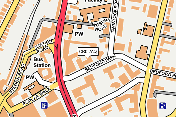
CR0 2AQ lies on Bedford Park in Croydon. CR0 2AQ is located in the Fairfield electoral ward, within the London borough of Croydon and the English Parliamentary constituency of Croydon Central. The Sub Integrated Care Board (ICB) Location is NHS South West London ICB - 36L and the police force is Metropolitan Police. This postcode has been in use since January 1980.


GetTheData
Source: OS OpenMap – Local (Ordnance Survey)
Source: OS VectorMap District (Ordnance Survey)
Licence: Open Government Licence (requires attribution)
| Easting | 532414 |
| Northing | 166150 |
| Latitude | 51.378966 |
| Longitude | -0.098744 |
GetTheData
Source: Open Postcode Geo
Licence: Open Government Licence
| Street | Bedford Park |
| Town/City | Croydon |
| Country | England |
| Postcode District | CR0 |
| ➜ CR0 open data dashboard ➜ See where CR0 is on a map ➜ Where is Croydon? | |
GetTheData
Source: Land Registry Price Paid Data
Licence: Open Government Licence
Elevation or altitude of CR0 2AQ as distance above sea level:
| Metres | Feet | |
|---|---|---|
| Elevation | 50m | 164ft |
Elevation is measured from the approximate centre of the postcode, to the nearest point on an OS contour line from OS Terrain 50, which has contour spacing of ten vertical metres.
➜ How high above sea level am I? Find the elevation of your current position using your device's GPS.
GetTheData
Source: Open Postcode Elevation
Licence: Open Government Licence
| Ward | Fairfield |
| Constituency | Croydon Central |
GetTheData
Source: ONS Postcode Database
Licence: Open Government Licence
| January 2024 | Anti-social behaviour | On or near Kidderminster Road | 489m |
| January 2024 | Drugs | On or near Kidderminster Road | 489m |
| January 2024 | Violence and sexual offences | On or near Kidderminster Road | 489m |
| ➜ Bedford Park crime map and outcomes | |||
GetTheData
Source: data.police.uk
Licence: Open Government Licence
| Delta Point (Wellesley Road) | Croydon | 106m |
| St Mary's Church West Croydon (Wellesley Road) | Croydon | 120m |
| Lunar House | Croydon | 136m |
| Lunar House (Wellesley Road) | Croydon | 137m |
| West Croydon Bus Station (St Michael's Road) | West Croydon | 151m |
| West Croydon Tram Stop (Station Road) | Croydon | 204m |
| Wellesley Road Tram Stop (Wellesley Road) | Croydon | 409m |
| Centrale Tram Stop (Tamworth Road) | Croydon | 505m |
| George Street Tram Stop (George Street) | Croydon | 555m |
| East Croydon Tram Stop (George Street) | Croydon | 636m |
| West Croydon Station | 0.3km |
| East Croydon Station | 0.6km |
| Selhurst Station | 1.6km |
GetTheData
Source: NaPTAN
Licence: Open Government Licence
GetTheData
Source: ONS Postcode Database
Licence: Open Government Licence


➜ Get more ratings from the Food Standards Agency
GetTheData
Source: Food Standards Agency
Licence: FSA terms & conditions
| Last Collection | |||
|---|---|---|---|
| Location | Mon-Fri | Sat | Distance |
| Sydenham Road (School) | 17:45 | 12:00 | 222m |
| Wellesley Road(Flats) | 18:15 | 12:00 | 287m |
| North End (Opp M&s) | 18:30 | 12:00 | 294m |
GetTheData
Source: Dracos
Licence: Creative Commons Attribution-ShareAlike
| Facility | Distance |
|---|---|
| Croydon Vision Wellesley Road, Croydon Sports Hall | 167m |
| St. Mary's Catholic High School Woburn Road, Croydon Sports Hall | 191m |
| Solutions Health And Fitness Club Lansdowne Road, Croydon Health and Fitness Gym, Swimming Pool, Studio | 228m |
GetTheData
Source: Active Places
Licence: Open Government Licence
| School | Phase of Education | Distance |
|---|---|---|
| St Mary's Catholic High School Woburn Road, Croydon, CR9 2EE | Secondary | 191m |
| St Mary's Catholic Infant School Bedford Park, Croydon, CR0 2AQ | Primary | 215m |
| St. Mary's Catholic Junior School Sydenham Road, Croydon, CR0 2EW | Primary | 259m |
GetTheData
Source: Edubase
Licence: Open Government Licence
The below table lists the International Territorial Level (ITL) codes (formerly Nomenclature of Territorial Units for Statistics (NUTS) codes) and Local Administrative Units (LAU) codes for CR0 2AQ:
| ITL 1 Code | Name |
|---|---|
| TLI | London |
| ITL 2 Code | Name |
| TLI6 | Outer London - South |
| ITL 3 Code | Name |
| TLI62 | Croydon |
| LAU 1 Code | Name |
| E09000008 | Croydon |
GetTheData
Source: ONS Postcode Directory
Licence: Open Government Licence
The below table lists the Census Output Area (OA), Lower Layer Super Output Area (LSOA), and Middle Layer Super Output Area (MSOA) for CR0 2AQ:
| Code | Name | |
|---|---|---|
| OA | E00005197 | |
| LSOA | E01001045 | Croydon 027C |
| MSOA | E02000220 | Croydon 027 |
GetTheData
Source: ONS Postcode Directory
Licence: Open Government Licence
| CR0 2FT | Saffron Central Square | 41m |
| CR0 2FS | Saffron Central Square | 79m |
| CR0 2FR | Saffron Central Square | 83m |
| CR0 2FW | Saffron Central Square | 84m |
| CR0 2FX | Saffron Central Square | 84m |
| CR0 2FY | Saffron Central Square | 84m |
| CR0 2AS | Tavistock Road | 146m |
| CR0 2AB | Woburn Road | 157m |
| CR0 2EU | Sydenham Road | 172m |
| CR0 2DU | Sydenham Road | 207m |
GetTheData
Source: Open Postcode Geo; Land Registry Price Paid Data
Licence: Open Government Licence