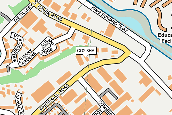
CO2 8HA lies on Whitehall Road in Colchester. CO2 8HA is located in the Old Heath and The Hythe electoral ward, within the local authority district of Colchester and the English Parliamentary constituency of Colchester. The Sub Integrated Care Board (ICB) Location is NHS Suffolk and North East Essex ICB - 06T and the police force is Essex. This postcode has been in use since January 1980.


GetTheData
Source: OS OpenMap – Local (Ordnance Survey)
Source: OS VectorMap District (Ordnance Survey)
Licence: Open Government Licence (requires attribution)
| Easting | 601812 |
| Northing | 223866 |
| Latitude | 51.876832 |
| Longitude | 0.930472 |
GetTheData
Source: Open Postcode Geo
Licence: Open Government Licence
| Street | Whitehall Road |
| Town/City | Colchester |
| Country | England |
| Postcode District | CO2 |
| ➜ CO2 open data dashboard ➜ See where CO2 is on a map ➜ Where is Colchester? | |
GetTheData
Source: Land Registry Price Paid Data
Licence: Open Government Licence
Elevation or altitude of CO2 8HA as distance above sea level:
| Metres | Feet | |
|---|---|---|
| Elevation | 10m | 33ft |
Elevation is measured from the approximate centre of the postcode, to the nearest point on an OS contour line from OS Terrain 50, which has contour spacing of ten vertical metres.
➜ How high above sea level am I? Find the elevation of your current position using your device's GPS.
GetTheData
Source: Open Postcode Elevation
Licence: Open Government Licence
| Ward | Old Heath And The Hythe |
| Constituency | Colchester |
GetTheData
Source: ONS Postcode Database
Licence: Open Government Licence
103, WHITEHALL ROAD, COLCHESTER, CO2 8HA 2003 1 APR £210,000 |
GetTheData
Source: HM Land Registry Price Paid Data
Licence: Contains HM Land Registry data © Crown copyright and database right 2024. This data is licensed under the Open Government Licence v3.0.
| June 2022 | Anti-social behaviour | On or near Albany Gardens | 117m |
| June 2022 | Violence and sexual offences | On or near Albany Gardens | 117m |
| June 2022 | Violence and sexual offences | On or near Albany Gardens | 117m |
| ➜ Whitehall Road crime map and outcomes | |||
GetTheData
Source: data.police.uk
Licence: Open Government Licence
| Commerce Way (Whitehall Road) | Old Heath | 33m |
| Commerce Way (Whitehall Road) | Old Heath | 41m |
| Albany Gardens (Haven Road) | Colchester | 179m |
| Albany Gardens (Haven Road) | Colchester | 186m |
| Grange Way (Whitehall Road) | Old Heath | 324m |
| Hythe (Essex) Station | 1km |
| Colchester Town Station | 2.1km |
| Wivenhoe Station | 2.9km |
GetTheData
Source: NaPTAN
Licence: Open Government Licence
GetTheData
Source: ONS Postcode Database
Licence: Open Government Licence


➜ Get more ratings from the Food Standards Agency
GetTheData
Source: Food Standards Agency
Licence: FSA terms & conditions
| Last Collection | |||
|---|---|---|---|
| Location | Mon-Fri | Sat | Distance |
| Whitehall Road | 47m | ||
| Whitehall Road | 18:15 | 11:30 | 52m |
| Old Heath Post Office | 17:30 | 12:00 | 527m |
GetTheData
Source: Dracos
Licence: Creative Commons Attribution-ShareAlike
| Facility | Distance |
|---|---|
| Anytime Fitness (Colchester East) Haven Road, Colchester Health and Fitness Gym, Studio | 152m |
| Pump Gyms (Colchester) Grange Way, Colchester Health and Fitness Gym, Studio | 356m |
| Bannatyne Health Club (Colchester) Heath Business Park, Grange Way, Colchester Swimming Pool, Health and Fitness Gym, Studio | 449m |
GetTheData
Source: Active Places
Licence: Open Government Licence
| School | Phase of Education | Distance |
|---|---|---|
| Kendall Church of England Primary School Recreation Road, Colchester, CO1 2HH | Primary | 645m |
| Old Heath Community Primary School Old Heath Road, Colchester, CO2 8DD | Primary | 768m |
| University of Essex Wivenhoe Park, Colchester, CO4 3SQ | Not applicable | 955m |
GetTheData
Source: Edubase
Licence: Open Government Licence
The below table lists the International Territorial Level (ITL) codes (formerly Nomenclature of Territorial Units for Statistics (NUTS) codes) and Local Administrative Units (LAU) codes for CO2 8HA:
| ITL 1 Code | Name |
|---|---|
| TLH | East |
| ITL 2 Code | Name |
| TLH3 | Essex |
| ITL 3 Code | Name |
| TLH34 | Essex Haven Gateway |
| LAU 1 Code | Name |
| E07000071 | Colchester |
GetTheData
Source: ONS Postcode Directory
Licence: Open Government Licence
The below table lists the Census Output Area (OA), Lower Layer Super Output Area (LSOA), and Middle Layer Super Output Area (MSOA) for CO2 8HA:
| Code | Name | |
|---|---|---|
| OA | E00176434 | |
| LSOA | E01021664 | Colchester 016C |
| MSOA | E02004521 | Colchester 016 |
GetTheData
Source: ONS Postcode Directory
Licence: Open Government Licence
| CO2 8HU | Albany Gardens | 149m |
| CO2 8HR | Commerce Way | 164m |
| CO2 8HQ | Albany Gardens | 169m |
| CO2 8XZ | Ballantyne Drive | 217m |
| CO2 8HZ | Waterside Lane | 225m |
| CO2 8AP | Whitehall Road | 264m |
| CO2 8GN | Quayside Drive | 269m |
| CO2 8HW | Waterside Lane | 278m |
| CO2 8FA | Hilltop Close | 281m |
| CO2 8GE | Quayside Drive | 284m |
GetTheData
Source: Open Postcode Geo; Land Registry Price Paid Data
Licence: Open Government Licence