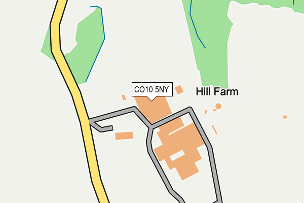
CO10 5NY is located in the Brett Vale electoral ward, within the local authority district of Babergh and the English Parliamentary constituency of South Suffolk. The Sub Integrated Care Board (ICB) Location is NHS Suffolk and North East Essex ICB - 06L and the police force is Suffolk. This postcode has been in use since January 1993.


GetTheData
Source: OS OpenMap – Local (Ordnance Survey)
Source: OS VectorMap District (Ordnance Survey)
Licence: Open Government Licence (requires attribution)
| Easting | 596185 |
| Northing | 238506 |
| Latitude | 52.010312 |
| Longitude | 0.857213 |
GetTheData
Source: Open Postcode Geo
Licence: Open Government Licence
| Country | England |
| Postcode District | CO10 |
| ➜ CO10 open data dashboard ➜ See where CO10 is on a map | |
GetTheData
Source: Land Registry Price Paid Data
Licence: Open Government Licence
Elevation or altitude of CO10 5NY as distance above sea level:
| Metres | Feet | |
|---|---|---|
| Elevation | 50m | 164ft |
Elevation is measured from the approximate centre of the postcode, to the nearest point on an OS contour line from OS Terrain 50, which has contour spacing of ten vertical metres.
➜ How high above sea level am I? Find the elevation of your current position using your device's GPS.
GetTheData
Source: Open Postcode Elevation
Licence: Open Government Licence
| Ward | Brett Vale |
| Constituency | South Suffolk |
GetTheData
Source: ONS Postcode Database
Licence: Open Government Licence
| Telephone Box (Stone Street) | Stone Street | 1,255m |
| Telephone Box (Stone Street) | Stone Street | 1,260m |
| Hare And Hounds (Old Road) | Leavenheath | 1,288m |
| Hare And Hounds (Old Road) | Leavenheath | 1,306m |
| Spring Lane (The Green) | Whitestreet Green | 1,694m |
GetTheData
Source: NaPTAN
Licence: Open Government Licence
| Percentage of properties with Next Generation Access | 100.0% |
| Percentage of properties with Superfast Broadband | 100.0% |
| Percentage of properties with Ultrafast Broadband | 0.0% |
| Percentage of properties with Full Fibre Broadband | 0.0% |
Superfast Broadband is between 30Mbps and 300Mbps
Ultrafast Broadband is > 300Mbps
| Percentage of properties unable to receive 2Mbps | 0.0% |
| Percentage of properties unable to receive 5Mbps | 0.0% |
| Percentage of properties unable to receive 10Mbps | 0.0% |
| Percentage of properties unable to receive 30Mbps | 0.0% |
GetTheData
Source: Ofcom
Licence: Ofcom Terms of Use (requires attribution)
GetTheData
Source: ONS Postcode Database
Licence: Open Government Licence


➜ Get more ratings from the Food Standards Agency
GetTheData
Source: Food Standards Agency
Licence: FSA terms & conditions
| Last Collection | |||
|---|---|---|---|
| Location | Mon-Fri | Sat | Distance |
| Honey Tye | 16:50 | 10:30 | 2,391m |
| Crossfields Butt Road | 16:30 | 10:30 | 3,022m |
| Stoke By Nayland Post Office | 17:15 | 11:00 | 3,497m |
GetTheData
Source: Dracos
Licence: Creative Commons Attribution-ShareAlike
| Facility | Distance |
|---|---|
| Leavenheath Village Green (Closed) Leavenheath, Colchester Grass Pitches | 1.2km |
| Peake Fitness At The Stoke By Nayland Club Keepers Lane, Stoke By Nayland Swimming Pool, Health and Fitness Gym, Golf, Studio, Squash Courts | 1.5km |
| Boxford Village Hall (Sudbury) Stone Street Road, Boxford, Sudbury Sports Hall | 1.9km |
GetTheData
Source: Active Places
Licence: Open Government Licence
| School | Phase of Education | Distance |
|---|---|---|
| Boxford Church of England Voluntary Controlled Primary School Stone Street Road, Boxford, Sudbury, CO10 5NP | Primary | 1.8km |
| OneSchool Global UK Colchester Campus Sudbury Road, Stoke by Nayland, Colchester, CO6 4RW | Not applicable | 2.8km |
| Stoke-by-Nayland Church of England Primary School School Street, Stoke by Nayland, Nr Colchester, CO6 4QY | Primary | 3.1km |
GetTheData
Source: Edubase
Licence: Open Government Licence
The below table lists the International Territorial Level (ITL) codes (formerly Nomenclature of Territorial Units for Statistics (NUTS) codes) and Local Administrative Units (LAU) codes for CO10 5NY:
| ITL 1 Code | Name |
|---|---|
| TLH | East |
| ITL 2 Code | Name |
| TLH1 | East Anglia |
| ITL 3 Code | Name |
| TLH14 | Suffolk CC |
| LAU 1 Code | Name |
| E07000200 | Babergh |
GetTheData
Source: ONS Postcode Directory
Licence: Open Government Licence
The below table lists the Census Output Area (OA), Lower Layer Super Output Area (LSOA), and Middle Layer Super Output Area (MSOA) for CO10 5NY:
| Code | Name | |
|---|---|---|
| OA | E00152385 | |
| LSOA | E01029902 | Babergh 009C |
| MSOA | E02006235 | Babergh 009 |
GetTheData
Source: ONS Postcode Directory
Licence: Open Government Licence
| CO10 5NT | Brick Kiln Hill Cottages | 752m |
| CO6 4PS | Stoke Road | 845m |
| CO6 4PR | Stoke Road | 1116m |
| CO6 4PP | Stoke Road | 1140m |
| CO6 4UH | Oaklands | 1147m |
| CO6 4UJ | Broad Oaks | 1159m |
| CO6 4PN | Harrow Street | 1186m |
| CO6 4QA | The Ridings | 1216m |
| CO6 4PW | Harrow Street | 1233m |
| CO6 4QB | The Old Road | 1235m |
GetTheData
Source: Open Postcode Geo; Land Registry Price Paid Data
Licence: Open Government Licence