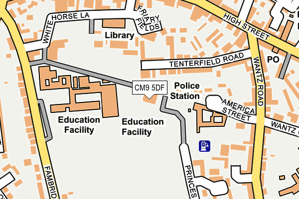
CM9 5DF is located in the Maldon North electoral ward, within the local authority district of Maldon and the English Parliamentary constituency of Maldon. The Sub Integrated Care Board (ICB) Location is NHS Mid and South Essex ICB - 06Q and the police force is Essex. This postcode has been in use since July 1995.


GetTheData
Source: OS OpenMap – Local (Ordnance Survey)
Source: OS VectorMap District (Ordnance Survey)
Licence: Open Government Licence (requires attribution)
| Easting | 585097 |
| Northing | 206798 |
| Latitude | 51.729336 |
| Longitude | 0.678834 |
GetTheData
Source: Open Postcode Geo
Licence: Open Government Licence
| Country | England |
| Postcode District | CM9 |
| ➜ CM9 open data dashboard ➜ See where CM9 is on a map ➜ Where is Maldon? | |
GetTheData
Source: Land Registry Price Paid Data
Licence: Open Government Licence
Elevation or altitude of CM9 5DF as distance above sea level:
| Metres | Feet | |
|---|---|---|
| Elevation | 20m | 66ft |
Elevation is measured from the approximate centre of the postcode, to the nearest point on an OS contour line from OS Terrain 50, which has contour spacing of ten vertical metres.
➜ How high above sea level am I? Find the elevation of your current position using your device's GPS.
GetTheData
Source: Open Postcode Elevation
Licence: Open Government Licence
| Ward | Maldon North |
| Constituency | Maldon |
GetTheData
Source: ONS Postcode Database
Licence: Open Government Licence
| January 2024 | Violence and sexual offences | On or near Parking Area | 211m |
| January 2024 | Violence and sexual offences | On or near Parking Area | 348m |
| January 2024 | Violence and sexual offences | On or near Parking Area | 348m |
| ➜ Get more crime data in our Crime section | |||
GetTheData
Source: data.police.uk
Licence: Open Government Licence
| The Swan Hotel (High Street) | Maldon Town Centre | 224m |
| Upper Plume School (Fambridge Road) | Maldon | 228m |
| The Swan Hotel (High Street) | Maldon Town Centre | 229m |
| Upper Plume School (Fambridge Road) | Maldon | 253m |
| Wantz Road (High Street) | Maldon | 255m |
GetTheData
Source: NaPTAN
Licence: Open Government Licence
GetTheData
Source: ONS Postcode Database
Licence: Open Government Licence


➜ Get more ratings from the Food Standards Agency
GetTheData
Source: Food Standards Agency
Licence: FSA terms & conditions
| Last Collection | |||
|---|---|---|---|
| Location | Mon-Fri | Sat | Distance |
| Wantz Corner | 17:30 | 11:30 | 245m |
| Maldon Post Office | 17:30 | 12:15 | 261m |
| West Square | 18:00 | 11:30 | 365m |
GetTheData
Source: Dracos
Licence: Creative Commons Attribution-ShareAlike
| Facility | Distance |
|---|---|
| Plume, Maldon's Community Academy Fambridge Road, Maldon Artificial Grass Pitch, Health and Fitness Gym, Grass Pitches, Sports Hall, Studio, Outdoor Tennis Courts | 154m |
| Snows Corner (Closed) Maldon Grass Pitches | 159m |
| Maldon Primary School Wantz Chase, Maldon Grass Pitches | 341m |
GetTheData
Source: Active Places
Licence: Open Government Licence
| School | Phase of Education | Distance |
|---|---|---|
| Plume School Fambridge Road, Maldon, CM9 6AB | Secondary | 154m |
| Maldon Primary School Wantz Chase, Maldon, CM9 5DQ | Primary | 328m |
| Maldon Court Preparatory School Silver Street, Maldon, CM9 4QE | Not applicable | 413m |
GetTheData
Source: Edubase
Licence: Open Government Licence
The below table lists the International Territorial Level (ITL) codes (formerly Nomenclature of Territorial Units for Statistics (NUTS) codes) and Local Administrative Units (LAU) codes for CM9 5DF:
| ITL 1 Code | Name |
|---|---|
| TLH | East |
| ITL 2 Code | Name |
| TLH3 | Essex |
| ITL 3 Code | Name |
| TLH36 | Heart of Essex |
| LAU 1 Code | Name |
| E07000074 | Maldon |
GetTheData
Source: ONS Postcode Directory
Licence: Open Government Licence
The below table lists the Census Output Area (OA), Lower Layer Super Output Area (LSOA), and Middle Layer Super Output Area (MSOA) for CM9 5DF:
| Code | Name | |
|---|---|---|
| OA | E00111207 | |
| LSOA | E01021890 | Maldon 004B |
| MSOA | E02004558 | Maldon 004 |
GetTheData
Source: ONS Postcode Directory
Licence: Open Government Licence
| CM9 5EW | Tenterfield Road | 100m |
| CM9 5EN | Tenterfield Road | 114m |
| CM9 5DJ | America Street | 123m |
| CM9 5FJ | Carmelite Way | 149m |
| CM9 5NY | Princes Road | 172m |
| CM9 5BA | The Dovecots | 186m |
| CM9 5ET | High Street | 198m |
| CM9 5HA | Wantz Haven | 209m |
| CM9 5QR | White Horse Lane | 217m |
| CM9 5DE | Wantz Road | 218m |
GetTheData
Source: Open Postcode Geo; Land Registry Price Paid Data
Licence: Open Government Licence