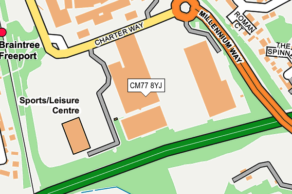
CM77 8YJ is located in the Braintree Central & Beckers Green electoral ward, within the local authority district of Braintree and the English Parliamentary constituency of Braintree. The Sub Integrated Care Board (ICB) Location is NHS Mid and South Essex ICB - 06Q and the police force is Essex. This postcode has been in use since June 2002.


GetTheData
Source: OS OpenMap – Local (Ordnance Survey)
Source: OS VectorMap District (Ordnance Survey)
Licence: Open Government Licence (requires attribution)
| Easting | 577178 |
| Northing | 222029 |
| Latitude | 51.868706 |
| Longitude | 0.572098 |
GetTheData
Source: Open Postcode Geo
Licence: Open Government Licence
| Country | England |
| Postcode District | CM77 |
| ➜ CM77 open data dashboard ➜ See where CM77 is on a map ➜ Where is Braintree? | |
GetTheData
Source: Land Registry Price Paid Data
Licence: Open Government Licence
Elevation or altitude of CM77 8YJ as distance above sea level:
| Metres | Feet | |
|---|---|---|
| Elevation | 60m | 197ft |
Elevation is measured from the approximate centre of the postcode, to the nearest point on an OS contour line from OS Terrain 50, which has contour spacing of ten vertical metres.
➜ How high above sea level am I? Find the elevation of your current position using your device's GPS.
GetTheData
Source: Open Postcode Elevation
Licence: Open Government Licence
| Ward | Braintree Central & Beckers Green |
| Constituency | Braintree |
GetTheData
Source: ONS Postcode Database
Licence: Open Government Licence
| January 2024 | Other theft | On or near Chelmer Road | 386m |
| December 2023 | Violence and sexual offences | On or near Chelmer Road | 386m |
| September 2023 | Vehicle crime | On or near Chelmer Road | 386m |
| ➜ Get more crime data in our Crime section | |||
GetTheData
Source: data.police.uk
Licence: Open Government Licence
| Freeport Railway Station (Charter Way) | Braintree | 145m |
| Freeport Railway Station (Charter Way) | Braintree | 156m |
| Freeport Railway Station (Charter Way) | Braintree | 177m |
| Mersea Fleetway (Chelmer Road) | Braintree | 337m |
| Mersea Fleetway (Chelmer Road) | Braintree | 348m |
| Braintree Freeport Station | 0.3km |
| Braintree Station | 1.3km |
| Cressing Station | 1.9km |
GetTheData
Source: NaPTAN
Licence: Open Government Licence
| Median download speed | 13.4Mbps |
| Average download speed | 37.8Mbps |
| Maximum download speed | 80.00Mbps |
| Median upload speed | 1.2Mbps |
| Average upload speed | 8.6Mbps |
| Maximum upload speed | 20.00Mbps |
GetTheData
Source: Ofcom
Licence: Ofcom Terms of Use (requires attribution)
GetTheData
Source: ONS Postcode Database
Licence: Open Government Licence


➜ Get more ratings from the Food Standards Agency
GetTheData
Source: Food Standards Agency
Licence: FSA terms & conditions
| Last Collection | |||
|---|---|---|---|
| Location | Mon-Fri | Sat | Distance |
| Orchard Drive | 17:30 | 09:15 | 846m |
| Masefield Road P.o. | 17:30 | 12:00 | 1,112m |
| Notley Road | 17:30 | 09:15 | 1,314m |
GetTheData
Source: Dracos
Licence: Creative Commons Attribution-ShareAlike
| Facility | Distance |
|---|---|
| Braintree Swimming & Fitness Charter Way, Braintree Swimming Pool, Health and Fitness Gym, Studio | 200m |
| Alec Hunter Academy Stubbs Lane, Braintree Grass Pitches, Sports Hall, Studio, Outdoor Tennis Courts | 477m |
| Braintree Lawn Tennis Club Clockhouse Way, Braintree Squash Courts, Outdoor Tennis Courts | 607m |
GetTheData
Source: Active Places
Licence: Open Government Licence
| School | Phase of Education | Distance |
|---|---|---|
| Alec Hunter Academy Stubbs Lane, Braintree, CM7 3NR | Secondary | 469m |
| Beckers Green Primary School Beckers Green Road, Braintree, CM7 3PR | Primary | 873m |
| John Ray Infant School Notley Road, Braintree, CM7 1HL | Primary | 1.3km |
GetTheData
Source: Edubase
Licence: Open Government Licence
The below table lists the International Territorial Level (ITL) codes (formerly Nomenclature of Territorial Units for Statistics (NUTS) codes) and Local Administrative Units (LAU) codes for CM77 8YJ:
| ITL 1 Code | Name |
|---|---|
| TLH | East |
| ITL 2 Code | Name |
| TLH3 | Essex |
| ITL 3 Code | Name |
| TLH34 | Essex Haven Gateway |
| LAU 1 Code | Name |
| E07000067 | Braintree |
GetTheData
Source: ONS Postcode Directory
Licence: Open Government Licence
The below table lists the Census Output Area (OA), Lower Layer Super Output Area (LSOA), and Middle Layer Super Output Area (MSOA) for CM77 8YJ:
| Code | Name | |
|---|---|---|
| OA | E00108539 | |
| LSOA | E01021368 | Braintree 011A |
| MSOA | E02004456 | Braintree 011 |
GetTheData
Source: ONS Postcode Directory
Licence: Open Government Licence
| CM7 3YW | Roman Court | 236m |
| CM7 3PZ | Mersea Fleet Way | 245m |
| CM7 3PY | Chelmer Road | 290m |
| CM7 3YX | The Spinney | 295m |
| CM7 3XP | Bradwell Court | 328m |
| CM7 3PX | Chelmer Road | 339m |
| CM7 3PU | Cant Way | 346m |
| CM7 1TW | Rushmoor Drive | 356m |
| CM7 3YU | Mundon Road | 357m |
| CM7 3YN | Colne Walk | 364m |
GetTheData
Source: Open Postcode Geo; Land Registry Price Paid Data
Licence: Open Government Licence