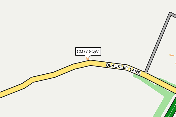
CM77 8QW lies on Blackley Lane in Black Notley, Braintree. CM77 8QW is located in the Felsted & Stebbing electoral ward, within the local authority district of Uttlesford and the English Parliamentary constituency of Saffron Walden. The Sub Integrated Care Board (ICB) Location is NHS Hertfordshire and West Essex ICB - 07H and the police force is Essex. This postcode has been in use since June 2002.


GetTheData
Source: OS OpenMap – Local (Ordnance Survey)
Source: OS VectorMap District (Ordnance Survey)
Licence: Open Government Licence (requires attribution)
| Easting | 573487 |
| Northing | 219738 |
| Latitude | 51.849286 |
| Longitude | 0.517394 |
GetTheData
Source: Open Postcode Geo
Licence: Open Government Licence
| Street | Blackley Lane |
| Locality | Black Notley |
| Town/City | Braintree |
| Country | England |
| Postcode District | CM77 |
| ➜ CM77 open data dashboard ➜ See where CM77 is on a map | |
GetTheData
Source: Land Registry Price Paid Data
Licence: Open Government Licence
Elevation or altitude of CM77 8QW as distance above sea level:
| Metres | Feet | |
|---|---|---|
| Elevation | 70m | 230ft |
Elevation is measured from the approximate centre of the postcode, to the nearest point on an OS contour line from OS Terrain 50, which has contour spacing of ten vertical metres.
➜ How high above sea level am I? Find the elevation of your current position using your device's GPS.
GetTheData
Source: Open Postcode Elevation
Licence: Open Government Licence
| Ward | Felsted & Stebbing |
| Constituency | Saffron Walden |
GetTheData
Source: ONS Postcode Database
Licence: Open Government Licence
| Green Dragon (London Road) | Youngs End | 455m |
| Green Dragon (London Road) | Youngs End | 464m |
| Dagnets Lane (London Road) | Youngs End | 490m |
| Dagnets Lane (London Road) | Youngs End | 496m |
| Lyndeswood Farm (London Road) | Youngs End | 570m |
| Braintree Station | 4km |
| Braintree Freeport Station | 4.2km |
| Cressing Station | 4.2km |
GetTheData
Source: NaPTAN
Licence: Open Government Licence
| Percentage of properties with Next Generation Access | 100.0% |
| Percentage of properties with Superfast Broadband | 0.0% |
| Percentage of properties with Ultrafast Broadband | 0.0% |
| Percentage of properties with Full Fibre Broadband | 0.0% |
Superfast Broadband is between 30Mbps and 300Mbps
Ultrafast Broadband is > 300Mbps
| Percentage of properties unable to receive 2Mbps | 0.0% |
| Percentage of properties unable to receive 5Mbps | 0.0% |
| Percentage of properties unable to receive 10Mbps | 0.0% |
| Percentage of properties unable to receive 30Mbps | 100.0% |
GetTheData
Source: Ofcom
Licence: Ofcom Terms of Use (requires attribution)
GetTheData
Source: ONS Postcode Database
Licence: Open Government Licence


➜ Get more ratings from the Food Standards Agency
GetTheData
Source: Food Standards Agency
Licence: FSA terms & conditions
| Last Collection | |||
|---|---|---|---|
| Location | Mon-Fri | Sat | Distance |
| Youngs End | 16:00 | 07:30 | 454m |
| Whitecourts | 16:00 | 09:15 | 1,534m |
| Beddalls End | 16:00 | 09:15 | 2,223m |
GetTheData
Source: Dracos
Licence: Creative Commons Attribution-ShareAlike
| Facility | Distance |
|---|---|
| Notley Green Notley Green, Great Notley, Braintree Grass Pitches | 970m |
| Discovery Centre Great Notley, Braintree Artificial Grass Pitch, Grass Pitches | 1.6km |
| Great Notley Country Park London Road, Great Notley, Braintree Grass Pitches, Artificial Grass Pitch, Outdoor Tennis Courts | 1.7km |
GetTheData
Source: Active Places
Licence: Open Government Licence
| School | Phase of Education | Distance |
|---|---|---|
| White Court School Ennerdale Avenue, Great Notley, Braintree, CM77 7UE | Primary | 1.3km |
| Notley Green Primary School Blickling Road, Great Notley, Braintree, CM77 7ZJ | Primary | 2km |
| Great Leighs Primary School Aragon Road, Great Leighs, Chelmsford, CM3 1RP | Primary | 2.5km |
GetTheData
Source: Edubase
Licence: Open Government Licence
The below table lists the International Territorial Level (ITL) codes (formerly Nomenclature of Territorial Units for Statistics (NUTS) codes) and Local Administrative Units (LAU) codes for CM77 8QW:
| ITL 1 Code | Name |
|---|---|
| TLH | East |
| ITL 2 Code | Name |
| TLH3 | Essex |
| ITL 3 Code | Name |
| TLH35 | West Essex |
| LAU 1 Code | Name |
| E07000077 | Uttlesford |
GetTheData
Source: ONS Postcode Directory
Licence: Open Government Licence
The below table lists the Census Output Area (OA), Lower Layer Super Output Area (LSOA), and Middle Layer Super Output Area (MSOA) for CM77 8QW:
| Code | Name | |
|---|---|---|
| OA | E00112111 | |
| LSOA | E01022064 | Uttlesford 008B |
| MSOA | E02004598 | Uttlesford 008 |
GetTheData
Source: ONS Postcode Directory
Licence: Open Government Licence
| CM77 7QL | London Road | 431m |
| CM77 8QN | London Road | 504m |
| CM77 7YB | Teal Close | 600m |
| CM77 7TZ | Elder Field | 641m |
| CM77 7UW | Great Notley Avenue | 691m |
| CM77 7PR | Stanstrete Field | 705m |
| CM77 7YD | Mallard Close | 729m |
| CM77 7WB | Wigeon Close | 748m |
| CM77 7JW | Stanstrete Field | 752m |
| CM77 7QX | The Chase | 771m |
GetTheData
Source: Open Postcode Geo; Land Registry Price Paid Data
Licence: Open Government Licence