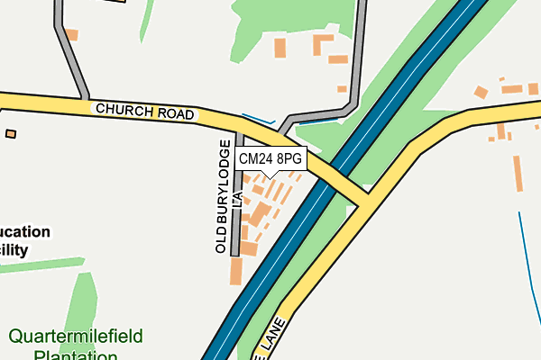
CM24 8PG is located in the Stansted South & Birchanger electoral ward, within the local authority district of Uttlesford and the English Parliamentary constituency of Saffron Walden. The Sub Integrated Care Board (ICB) Location is NHS Hertfordshire and West Essex ICB - 07H and the police force is Essex. This postcode has been in use since August 1993.


GetTheData
Source: OS OpenMap – Local (Ordnance Survey)
Source: OS VectorMap District (Ordnance Survey)
Licence: Open Government Licence (requires attribution)
| Easting | 552288 |
| Northing | 223964 |
| Latitude | 51.893433 |
| Longitude | 0.211742 |
GetTheData
Source: Open Postcode Geo
Licence: Open Government Licence
| Country | England |
| Postcode District | CM24 |
| ➜ CM24 open data dashboard ➜ See where CM24 is on a map ➜ Where is Burton End? | |
GetTheData
Source: Land Registry Price Paid Data
Licence: Open Government Licence
Elevation or altitude of CM24 8PG as distance above sea level:
| Metres | Feet | |
|---|---|---|
| Elevation | 100m | 328ft |
Elevation is measured from the approximate centre of the postcode, to the nearest point on an OS contour line from OS Terrain 50, which has contour spacing of ten vertical metres.
➜ How high above sea level am I? Find the elevation of your current position using your device's GPS.
GetTheData
Source: Open Postcode Elevation
Licence: Open Government Licence
| Ward | Stansted South & Birchanger |
| Constituency | Saffron Walden |
GetTheData
Source: ONS Postcode Database
Licence: Open Government Licence
| September 2023 | Other theft | On or near Old Burylodge Lane | 41m |
| August 2023 | Violence and sexual offences | On or near Old Burylodge Lane | 41m |
| August 2023 | Violence and sexual offences | On or near Old Burylodge Lane | 41m |
| ➜ Get more crime data in our Crime section | |||
GetTheData
Source: data.police.uk
Licence: Open Government Licence
| School (Church Road) | Stansted Mountfitchet | 339m |
| School (Church Road) | Stansted Mountfitchet | 340m |
| Palmer Close (Foresthall Road) | Stansted Mountfitchet | 693m |
| Palmer Close (Foresthall Road) | Stansted Mountfitchet | 697m |
| Reeve Road (Foresthall Road) | Stansted Mountfitchet | 905m |
| Stansted Mountfitchet Station | 1.2km |
| Elsenham Station | 3.2km |
| Stansted Airport Station | 3.4km |
GetTheData
Source: NaPTAN
Licence: Open Government Licence
| Percentage of properties with Next Generation Access | 100.0% |
| Percentage of properties with Superfast Broadband | 0.0% |
| Percentage of properties with Ultrafast Broadband | 0.0% |
| Percentage of properties with Full Fibre Broadband | 0.0% |
Superfast Broadband is between 30Mbps and 300Mbps
Ultrafast Broadband is > 300Mbps
| Percentage of properties unable to receive 2Mbps | 0.0% |
| Percentage of properties unable to receive 5Mbps | 0.0% |
| Percentage of properties unable to receive 10Mbps | 0.0% |
| Percentage of properties unable to receive 30Mbps | 100.0% |
GetTheData
Source: Ofcom
Licence: Ofcom Terms of Use (requires attribution)
GetTheData
Source: ONS Postcode Database
Licence: Open Government Licence


➜ Get more ratings from the Food Standards Agency
GetTheData
Source: Food Standards Agency
Licence: FSA terms & conditions
| Last Collection | |||
|---|---|---|---|
| Location | Mon-Fri | Sat | Distance |
| 7 Chapel Hill | 17:30 | 11:30 | 1,320m |
| Stansted Old Post Office | 17:30 | 11:00 | 1,556m |
| Wood End Green | 16:30 | 09:00 | 1,745m |
GetTheData
Source: Dracos
Licence: Creative Commons Attribution-ShareAlike
| Facility | Distance |
|---|---|
| Forest Hall School Forest Hall Road, Stansted Grass Pitches, Sports Hall, Outdoor Tennis Courts | 370m |
| Mountfitchet Romeera Leisure Centre Forest Hall Road, Stansted Sports Hall, Health and Fitness Gym, Studio, Outdoor Tennis Courts | 381m |
| Stansted Airport Pitch Second Avenue, Stansted Grass Pitches | 1.3km |
GetTheData
Source: Active Places
Licence: Open Government Licence
| School | Phase of Education | Distance |
|---|---|---|
| Forest Hall School Forest Hall Road, Stansted Mountfitchet, CM24 8TZ | Secondary | 296m |
| St Mary's CofE Foundation Primary School Hampton Road, Stansted, CM24 8FE | Primary | 982m |
| Magna Carta Primary Academy St John's Road, Stansted Mountfitchet, CM24 8JP | Primary | 1.5km |
GetTheData
Source: Edubase
Licence: Open Government Licence
The below table lists the International Territorial Level (ITL) codes (formerly Nomenclature of Territorial Units for Statistics (NUTS) codes) and Local Administrative Units (LAU) codes for CM24 8PG:
| ITL 1 Code | Name |
|---|---|
| TLH | East |
| ITL 2 Code | Name |
| TLH3 | Essex |
| ITL 3 Code | Name |
| TLH35 | West Essex |
| LAU 1 Code | Name |
| E07000077 | Uttlesford |
GetTheData
Source: ONS Postcode Directory
Licence: Open Government Licence
The below table lists the Census Output Area (OA), Lower Layer Super Output Area (LSOA), and Middle Layer Super Output Area (MSOA) for CM24 8PG:
| Code | Name | |
|---|---|---|
| OA | E00112222 | |
| LSOA | E01022086 | Uttlesford 006A |
| MSOA | E02004596 | Uttlesford 006 |
GetTheData
Source: ONS Postcode Directory
Licence: Open Government Licence
| CM24 8UD | 160m | |
| CM24 8UE | 338m | |
| CM24 8UA | Churchill Corner | 504m |
| CM24 8UF | 574m | |
| CM24 8TX | Forest Hall Road | 576m |
| CM24 8SH | Jordon Close | 605m |
| CM24 8FB | Palmer Close | 665m |
| CM24 8FD | Harbridge Close | 753m |
| CM24 8QB | Church Road | 757m |
| CM24 8FY | Haggerwood Way | 786m |
GetTheData
Source: Open Postcode Geo; Land Registry Price Paid Data
Licence: Open Government Licence