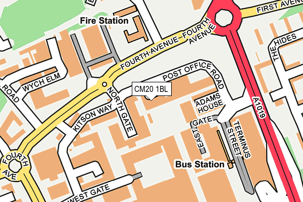
CM20 1BL is located in the Toddbrook electoral ward, within the local authority district of Harlow and the English Parliamentary constituency of Harlow. The Sub Integrated Care Board (ICB) Location is NHS Hertfordshire and West Essex ICB - 07H and the police force is Essex. This postcode has been in use since January 1980.


GetTheData
Source: OS OpenMap – Local (Ordnance Survey)
Source: OS VectorMap District (Ordnance Survey)
Licence: Open Government Licence (requires attribution)
| Easting | 544510 |
| Northing | 210159 |
| Latitude | 51.771463 |
| Longitude | 0.093033 |
GetTheData
Source: Open Postcode Geo
Licence: Open Government Licence
| Country | England |
| Postcode District | CM20 |
| ➜ CM20 open data dashboard ➜ See where CM20 is on a map ➜ Where is Harlow? | |
GetTheData
Source: Land Registry Price Paid Data
Licence: Open Government Licence
Elevation or altitude of CM20 1BL as distance above sea level:
| Metres | Feet | |
|---|---|---|
| Elevation | 70m | 230ft |
Elevation is measured from the approximate centre of the postcode, to the nearest point on an OS contour line from OS Terrain 50, which has contour spacing of ten vertical metres.
➜ How high above sea level am I? Find the elevation of your current position using your device's GPS.
GetTheData
Source: Open Postcode Elevation
Licence: Open Government Licence
| Ward | Toddbrook |
| Constituency | Harlow |
GetTheData
Source: ONS Postcode Database
Licence: Open Government Licence
| December 2023 | Burglary | On or near Hamstel Road | 445m |
| December 2023 | Violence and sexual offences | On or near Hamstel Road | 445m |
| November 2023 | Other theft | On or near Parking Area | 228m |
| ➜ Get more crime data in our Crime section | |||
GetTheData
Source: data.police.uk
Licence: Open Government Licence
| Bus Garage (Fourth Avenue) | Harlow Town Centre | 122m |
| Bus Garage (Fourth Avenue) | Harlow Town Centre | 151m |
| Bus Station (Terminus Street) | Harlow Town Centre | 183m |
| Bus Station (Terminus Street) | Harlow Town Centre | 194m |
| Wych Elm (Hamstel Road) | Harlow | 296m |
| Harlow Town Station | 1.1km |
| Harlow Mill Station | 3.4km |
| Roydon Station | 3.9km |
GetTheData
Source: NaPTAN
Licence: Open Government Licence
| Percentage of properties with Next Generation Access | 0.0% |
| Percentage of properties with Superfast Broadband | 0.0% |
| Percentage of properties with Ultrafast Broadband | 0.0% |
| Percentage of properties with Full Fibre Broadband | 0.0% |
Superfast Broadband is between 30Mbps and 300Mbps
Ultrafast Broadband is > 300Mbps
| Percentage of properties unable to receive 2Mbps | 0.0% |
| Percentage of properties unable to receive 5Mbps | 0.0% |
| Percentage of properties unable to receive 10Mbps | 0.0% |
| Percentage of properties unable to receive 30Mbps | 100.0% |
GetTheData
Source: Ofcom
Licence: Ofcom Terms of Use (requires attribution)
GetTheData
Source: ONS Postcode Database
Licence: Open Government Licence


➜ Get more ratings from the Food Standards Agency
GetTheData
Source: Food Standards Agency
Licence: FSA terms & conditions
| Last Collection | |||
|---|---|---|---|
| Location | Mon-Fri | Sat | Distance |
| Tanys Dell | 17:15 | 12:00 | 436m |
| River Mill | 17:15 | 12:00 | 618m |
| Rectory Wood | 17:15 | 12:00 | 685m |
GetTheData
Source: Dracos
Licence: Creative Commons Attribution-ShareAlike
| Facility | Distance |
|---|---|
| Fit4less (Harlow) (Closed) Terminus Street, Harlow Health and Fitness Gym | 213m |
| Ripped Gym (Harlow) Wych Elm, Harlow Health and Fitness Gym | 228m |
| Jd Gyms (Harlow) Broad Walk, Harlow Health and Fitness Gym | 242m |
GetTheData
Source: Active Places
Licence: Open Government Licence
| School | Phase of Education | Distance |
|---|---|---|
| Harlow College Velizy Avenue, Harlow, CM20 3LH | 16 plus | 438m |
| Bmat Stem Academy Velizy Avenue, Harlow, CM20 3EZ | Secondary | 483m |
| Pemberley Academy Hodings Road, Harlow, CM20 1NW | Primary | 543m |
GetTheData
Source: Edubase
Licence: Open Government Licence
The below table lists the International Territorial Level (ITL) codes (formerly Nomenclature of Territorial Units for Statistics (NUTS) codes) and Local Administrative Units (LAU) codes for CM20 1BL:
| ITL 1 Code | Name |
|---|---|
| TLH | East |
| ITL 2 Code | Name |
| TLH3 | Essex |
| ITL 3 Code | Name |
| TLH35 | West Essex |
| LAU 1 Code | Name |
| E07000073 | Harlow |
GetTheData
Source: ONS Postcode Directory
Licence: Open Government Licence
The below table lists the Census Output Area (OA), Lower Layer Super Output Area (LSOA), and Middle Layer Super Output Area (MSOA) for CM20 1BL:
| Code | Name | |
|---|---|---|
| OA | E00111095 | |
| LSOA | E01021872 | Harlow 007E |
| MSOA | E02004550 | Harlow 007 |
GetTheData
Source: ONS Postcode Directory
Licence: Open Government Licence
| CM20 1BX | The Rows | 28m |
| CM20 1BZ | The Rows | 56m |
| CM20 1JJ | West Square | 92m |
| CM20 1BD | 123m | |
| CM20 1QR | Wych Elm | 194m |
| CM20 1XA | Terminus Street | 231m |
| CM20 3QP | The Hides | 231m |
| CM20 1QP | Wych Elm | 232m |
| CM20 1FF | Kitson Way | 254m |
| CM20 1FG | Kitson Way | 254m |
GetTheData
Source: Open Postcode Geo; Land Registry Price Paid Data
Licence: Open Government Licence