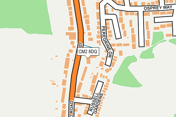
CM2 8DQ is located in the Goat Hall electoral ward, within the local authority district of Chelmsford and the English Parliamentary constituency of Chelmsford. The Sub Integrated Care Board (ICB) Location is NHS Mid and South Essex ICB - 06Q and the police force is Essex. This postcode has been in use since August 1993.


GetTheData
Source: OS OpenMap – Local (Ordnance Survey)
Source: OS VectorMap District (Ordnance Survey)
Licence: Open Government Licence (requires attribution)
| Easting | 570365 |
| Northing | 203901 |
| Latitude | 51.707979 |
| Longitude | 0.464319 |
GetTheData
Source: Open Postcode Geo
Licence: Open Government Licence
| Country | England |
| Postcode District | CM2 |
| ➜ CM2 open data dashboard ➜ See where CM2 is on a map ➜ Where is Chelmsford? | |
GetTheData
Source: Land Registry Price Paid Data
Licence: Open Government Licence
Elevation or altitude of CM2 8DQ as distance above sea level:
| Metres | Feet | |
|---|---|---|
| Elevation | 60m | 197ft |
Elevation is measured from the approximate centre of the postcode, to the nearest point on an OS contour line from OS Terrain 50, which has contour spacing of ten vertical metres.
➜ How high above sea level am I? Find the elevation of your current position using your device's GPS.
GetTheData
Source: Open Postcode Elevation
Licence: Open Government Licence
| Ward | Goat Hall |
| Constituency | Chelmsford |
GetTheData
Source: ONS Postcode Database
Licence: Open Government Licence
| December 2023 | Criminal damage and arson | On or near Parking Area | 453m |
| September 2023 | Violence and sexual offences | On or near Parking Area | 453m |
| September 2023 | Violence and sexual offences | On or near Parking Area | 453m |
| ➜ Get more crime data in our Crime section | |||
GetTheData
Source: data.police.uk
Licence: Open Government Licence
| Fowlers Court (Galleywood Road) | Tile Kiln | 51m |
| Fowlers Court (Galleywood Road) | Tile Kiln | 98m |
| Russell Gardens (Galleywood Road) | Chelmsford | 162m |
| Russell Gardens (Galleywood Road) | Chelmsford | 174m |
| Peregrine Drive (Osprey Way) | Tile Kiln | 212m |
| Chelmsford Station | 3.2km |
GetTheData
Source: NaPTAN
Licence: Open Government Licence
| Percentage of properties with Next Generation Access | 100.0% |
| Percentage of properties with Superfast Broadband | 100.0% |
| Percentage of properties with Ultrafast Broadband | 0.0% |
| Percentage of properties with Full Fibre Broadband | 0.0% |
Superfast Broadband is between 30Mbps and 300Mbps
Ultrafast Broadband is > 300Mbps
| Percentage of properties unable to receive 2Mbps | 0.0% |
| Percentage of properties unable to receive 5Mbps | 0.0% |
| Percentage of properties unable to receive 10Mbps | 0.0% |
| Percentage of properties unable to receive 30Mbps | 0.0% |
GetTheData
Source: Ofcom
Licence: Ofcom Terms of Use (requires attribution)
GetTheData
Source: ONS Postcode Database
Licence: Open Government Licence


➜ Get more ratings from the Food Standards Agency
GetTheData
Source: Food Standards Agency
Licence: FSA terms & conditions
| Last Collection | |||
|---|---|---|---|
| Location | Mon-Fri | Sat | Distance |
| Pipers Tye | 17:35 | 12:20 | 1,328m |
| Tesco Princes Road | 17:50 | 12:40 | 1,464m |
| Gloucester Avenue P.o. | 17:50 | 12:20 | 1,477m |
GetTheData
Source: Dracos
Licence: Creative Commons Attribution-ShareAlike
| Facility | Distance |
|---|---|
| Clarks Field Slades Lane, Chelmsford Grass Pitches | 400m |
| Chelmsford Hockey Club Beehive Lane, Chelmsford Artificial Grass Pitch | 433m |
| Chelmer Park Beehive Lane, Chelmsford Artificial Grass Pitch, Grass Pitches, Outdoor Tennis Courts | 433m |
GetTheData
Source: Active Places
Licence: Open Government Licence
| School | Phase of Education | Distance |
|---|---|---|
| Mildmay Primary School Robin Way, Chelmsford, CM2 8AU | Primary | 466m |
| Thriftwood School Slades Lane, Galleywood, Chelmsford, CM2 8RW | Not applicable | 659m |
| St Michael's Church of England Voluntary Aided Junior School Barnard Road, Galleywood, Chelmsford, CM2 8RR | Primary | 1.2km |
GetTheData
Source: Edubase
Licence: Open Government Licence
The below table lists the International Territorial Level (ITL) codes (formerly Nomenclature of Territorial Units for Statistics (NUTS) codes) and Local Administrative Units (LAU) codes for CM2 8DQ:
| ITL 1 Code | Name |
|---|---|
| TLH | East |
| ITL 2 Code | Name |
| TLH3 | Essex |
| ITL 3 Code | Name |
| TLH36 | Heart of Essex |
| LAU 1 Code | Name |
| E07000070 | Chelmsford |
GetTheData
Source: ONS Postcode Directory
Licence: Open Government Licence
The below table lists the Census Output Area (OA), Lower Layer Super Output Area (LSOA), and Middle Layer Super Output Area (MSOA) for CM2 8DQ:
| Code | Name | |
|---|---|---|
| OA | E00109502 | |
| LSOA | E01021559 | Chelmsford 017E |
| MSOA | E02004501 | Chelmsford 017 |
GetTheData
Source: ONS Postcode Directory
Licence: Open Government Licence
| CM2 8BY | Galleywood Road | 97m |
| CM2 8XY | Peregrine Drive | 105m |
| CM2 8DB | Russell Gardens | 141m |
| CM2 8XX | Plover Walk | 155m |
| CM2 8BS | Galleywood Road | 186m |
| CM2 8AP | Osprey Way | 218m |
| CM2 8BT | Galleywood Road | 239m |
| CM2 8XT | Swallow Path | 252m |
| CM2 8AR | Mallard Road | 283m |
| CM2 8XU | Osprey Way | 292m |
GetTheData
Source: Open Postcode Geo; Land Registry Price Paid Data
Licence: Open Government Licence