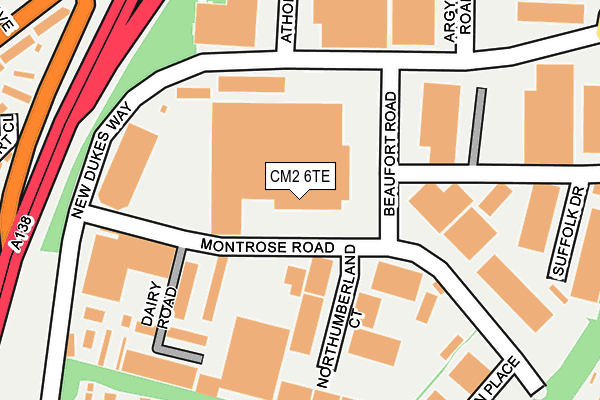
CM2 6TE is located in the Chelmer Village and Beaulieu Park electoral ward, within the local authority district of Chelmsford and the English Parliamentary constituency of Chelmsford. The Sub Integrated Care Board (ICB) Location is NHS Mid and South Essex ICB - 06Q and the police force is Essex. This postcode has been in use since March 1982.


GetTheData
Source: OS OpenMap – Local (Ordnance Survey)
Source: OS VectorMap District (Ordnance Survey)
Licence: Open Government Licence (requires attribution)
| Easting | 573032 |
| Northing | 207810 |
| Latitude | 51.742283 |
| Longitude | 0.504846 |
GetTheData
Source: Open Postcode Geo
Licence: Open Government Licence
| Country | England |
| Postcode District | CM2 |
| ➜ CM2 open data dashboard ➜ See where CM2 is on a map ➜ Where is Chelmsford? | |
GetTheData
Source: Land Registry Price Paid Data
Licence: Open Government Licence
Elevation or altitude of CM2 6TE as distance above sea level:
| Metres | Feet | |
|---|---|---|
| Elevation | 40m | 131ft |
Elevation is measured from the approximate centre of the postcode, to the nearest point on an OS contour line from OS Terrain 50, which has contour spacing of ten vertical metres.
➜ How high above sea level am I? Find the elevation of your current position using your device's GPS.
GetTheData
Source: Open Postcode Elevation
Licence: Open Government Licence
| Ward | Chelmer Village And Beaulieu Park |
| Constituency | Chelmsford |
GetTheData
Source: ONS Postcode Database
Licence: Open Government Licence
| February 2023 | Vehicle crime | On or near Chelmer Village Way | 485m |
| February 2023 | Other theft | On or near Chelmer Village Way | 485m |
| August 2022 | Vehicle crime | On or near Chelmer Village Way | 485m |
| ➜ Get more crime data in our Crime section | |||
GetTheData
Source: data.police.uk
Licence: Open Government Licence
| New Dukes Way | Chelmer Village | 223m |
| New Dukes Way | Chelmer Village | 234m |
| Golding Thoroughfare (New Dukes Way) | Chelmer Village | 340m |
| Golding Thoroughfare (New Dukes Way) | Chelmer Village | 344m |
| Chelmer Village Way | Chelmer Village | 426m |
| Chelmsford Station | 2.6km |
GetTheData
Source: NaPTAN
Licence: Open Government Licence
GetTheData
Source: ONS Postcode Database
Licence: Open Government Licence


➜ Get more ratings from the Food Standards Agency
GetTheData
Source: Food Standards Agency
Licence: FSA terms & conditions
| Last Collection | |||
|---|---|---|---|
| Location | Mon-Fri | Sat | Distance |
| Essex Distribution Centre | 435m | ||
| Chelmer Village Way | 17:40 | 12:00 | 451m |
| Upper Springfield Road | 17:30 | 11:30 | 645m |
GetTheData
Source: Dracos
Licence: Creative Commons Attribution-ShareAlike
| Facility | Distance |
|---|---|
| Barnes Farm County Junior School Henniker Gate, Chelmsford Grass Pitches, Outdoor Tennis Courts | 471m |
| Coronation Park (Chelmsford) Timsons Lane, Chelmsford Grass Pitches | 578m |
| Essex Police College Tyrells Close, Chelmsford Health and Fitness Gym, Sports Hall, Grass Pitches | 839m |
GetTheData
Source: Active Places
Licence: Open Government Licence
| School | Phase of Education | Distance |
|---|---|---|
| Barnes Farm Junior School Henniker Gate, Chelmer Village, Chelmsford, CM2 6QH | Primary | 467m |
| Barnes Farm Infant School Henniker Gate, Chelmsford, CM2 6QH | Primary | 467m |
| Chancellor Park Primary School, Chelmsford Brook End Road South, Chelmsford, CM2 6PT | Primary | 764m |
GetTheData
Source: Edubase
Licence: Open Government Licence
The below table lists the International Territorial Level (ITL) codes (formerly Nomenclature of Territorial Units for Statistics (NUTS) codes) and Local Administrative Units (LAU) codes for CM2 6TE:
| ITL 1 Code | Name |
|---|---|
| TLH | East |
| ITL 2 Code | Name |
| TLH3 | Essex |
| ITL 3 Code | Name |
| TLH36 | Heart of Essex |
| LAU 1 Code | Name |
| E07000070 | Chelmsford |
GetTheData
Source: ONS Postcode Directory
Licence: Open Government Licence
The below table lists the Census Output Area (OA), Lower Layer Super Output Area (LSOA), and Middle Layer Super Output Area (MSOA) for CM2 6TE:
| Code | Name | |
|---|---|---|
| OA | E00109459 | |
| LSOA | E01021544 | Chelmsford 008A |
| MSOA | E02004492 | Chelmsford 008 |
GetTheData
Source: ONS Postcode Directory
Licence: Open Government Licence
| CM2 6TY | Burton Place | 198m |
| CM2 6SG | Cawkwell Close | 234m |
| CM2 6TP | Emberson Court | 249m |
| CM2 6TR | Burgess Field | 250m |
| CM2 6XW | Buckingham Court | 260m |
| CM2 6SF | Hartley Close | 264m |
| CM2 6TS | Lovibond Place | 267m |
| CM2 6QE | Sheppard Drive | 286m |
| CM2 6UE | Burgess Field | 303m |
| CM2 6SW | Murrell Lock | 304m |
GetTheData
Source: Open Postcode Geo; Land Registry Price Paid Data
Licence: Open Government Licence