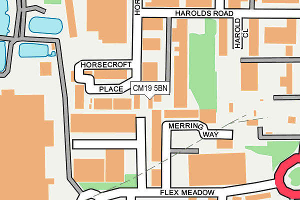
CM19 5BN is located in the Little Parndon and Hare Street electoral ward, within the local authority district of Harlow and the English Parliamentary constituency of Harlow. The Sub Integrated Care Board (ICB) Location is NHS Hertfordshire and West Essex ICB - 07H and the police force is Essex. This postcode has been in use since January 1980.


GetTheData
Source: OS OpenMap – Local (Ordnance Survey)
Source: OS VectorMap District (Ordnance Survey)
Licence: Open Government Licence (requires attribution)
| Easting | 542470 |
| Northing | 209302 |
| Latitude | 51.764280 |
| Longitude | 0.063109 |
GetTheData
Source: Open Postcode Geo
Licence: Open Government Licence
| Country | England |
| Postcode District | CM19 |
➜ See where CM19 is on a map ➜ Where is Harlow? | |
GetTheData
Source: Land Registry Price Paid Data
Licence: Open Government Licence
Elevation or altitude of CM19 5BN as distance above sea level:
| Metres | Feet | |
|---|---|---|
| Elevation | 70m | 230ft |
Elevation is measured from the approximate centre of the postcode, to the nearest point on an OS contour line from OS Terrain 50, which has contour spacing of ten vertical metres.
➜ How high above sea level am I? Find the elevation of your current position using your device's GPS.
GetTheData
Source: Open Postcode Elevation
Licence: Open Government Licence
| Ward | Little Parndon And Hare Street |
| Constituency | Harlow |
GetTheData
Source: ONS Postcode Database
Licence: Open Government Licence
| Merring Way (Flex Meadow) | Pinnacles | 186m |
| Shield House (Elizabeth Way) | Pinnacles | 312m |
| Shield House (Elizabeth Way) | Pinnacles | 320m |
| Flex Meadow | Pinnacles | 352m |
| Cawley Hatch (Elizabeth Way) | Pinnacles | 376m |
| Roydon Station | 2.2km |
| Harlow Town Station | 2.9km |
| Rye House Station | 4km |
GetTheData
Source: NaPTAN
Licence: Open Government Licence
GetTheData
Source: ONS Postcode Database
Licence: Open Government Licence

➜ Get more ratings from the Food Standards Agency
GetTheData
Source: Food Standards Agency
Licence: FSA terms & conditions
| Last Collection | |||
|---|---|---|---|
| Location | Mon-Fri | Sat | Distance |
| Hare Street | 17:15 | 12:00 | 722m |
| Colt Hatch | 17:15 | 12:00 | 1,655m |
| Hollyfield | 17:15 | 12:00 | 1,797m |
GetTheData
Source: Dracos
Licence: Creative Commons Attribution-ShareAlike
The below table lists the International Territorial Level (ITL) codes (formerly Nomenclature of Territorial Units for Statistics (NUTS) codes) and Local Administrative Units (LAU) codes for CM19 5BN:
| ITL 1 Code | Name |
|---|---|
| TLH | East |
| ITL 2 Code | Name |
| TLH3 | Essex |
| ITL 3 Code | Name |
| TLH35 | West Essex |
| LAU 1 Code | Name |
| E07000073 | Harlow |
GetTheData
Source: ONS Postcode Directory
Licence: Open Government Licence
The below table lists the Census Output Area (OA), Lower Layer Super Output Area (LSOA), and Middle Layer Super Output Area (MSOA) for CM19 5BN:
| Code | Name | |
|---|---|---|
| OA | E00110956 | |
| LSOA | E01021840 | Harlow 004B |
| MSOA | E02004547 | Harlow 004 |
GetTheData
Source: ONS Postcode Directory
Licence: Open Government Licence
| CM19 5SR | West Side Business Centre | 70m |
| CM19 5BX | Horsecroft Place | 81m |
| CM19 5BJ | Harolds Road | 87m |
| CM19 5BT | Horsecroft Place | 93m |
| CM19 5BH | Horsecroft Road | 112m |
| CM19 5BU | Horsecroft Place | 145m |
| CM19 5AR | Elizabeth Way | 277m |
| CM19 5TJ | Ash Industrial Estate | 298m |
| CM19 5FN | Barrows Road | 298m |
| CM19 5BZ | Roydenbury Industrial Estate | 468m |
GetTheData
Source: Open Postcode Geo; Land Registry Price Paid Data
Licence: Open Government Licence