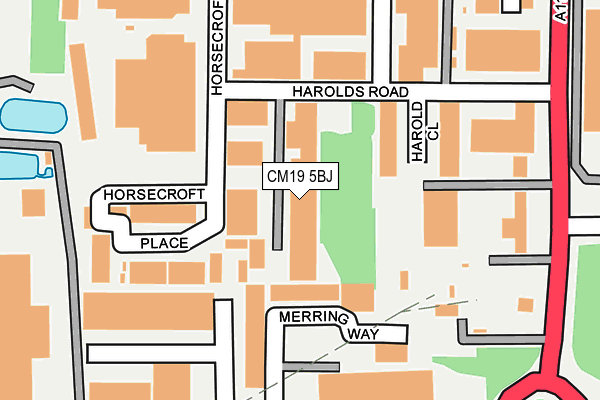
CM19 5BJ lies on Harolds Road in Harlow. CM19 5BJ is located in the Little Parndon and Hare Street electoral ward, within the local authority district of Harlow and the English Parliamentary constituency of Harlow. The Sub Integrated Care Board (ICB) Location is NHS Hertfordshire and West Essex ICB - 07H and the police force is Essex. This postcode has been in use since January 1980.


GetTheData
Source: OS OpenMap – Local (Ordnance Survey)
Source: OS VectorMap District (Ordnance Survey)
Licence: Open Government Licence (requires attribution)
| Easting | 542528 |
| Northing | 209367 |
| Latitude | 51.764855 |
| Longitude | 0.064003 |
GetTheData
Source: Open Postcode Geo
Licence: Open Government Licence
| Street | Harolds Road |
| Town/City | Harlow |
| Country | England |
| Postcode District | CM19 |
| ➜ CM19 open data dashboard ➜ See where CM19 is on a map ➜ Where is Harlow? | |
GetTheData
Source: Land Registry Price Paid Data
Licence: Open Government Licence
Elevation or altitude of CM19 5BJ as distance above sea level:
| Metres | Feet | |
|---|---|---|
| Elevation | 70m | 230ft |
Elevation is measured from the approximate centre of the postcode, to the nearest point on an OS contour line from OS Terrain 50, which has contour spacing of ten vertical metres.
➜ How high above sea level am I? Find the elevation of your current position using your device's GPS.
GetTheData
Source: Open Postcode Elevation
Licence: Open Government Licence
| Ward | Little Parndon And Hare Street |
| Constituency | Harlow |
GetTheData
Source: ONS Postcode Database
Licence: Open Government Licence
| December 2023 | Other theft | On or near Merring Way | 139m |
| December 2023 | Violence and sexual offences | On or near Merring Way | 139m |
| December 2023 | Violence and sexual offences | On or near Merring Way | 139m |
| ➜ Harolds Road crime map and outcomes | |||
GetTheData
Source: data.police.uk
Licence: Open Government Licence
| Merring Way (Flex Meadow) | Pinnacles | 245m |
| Shield House (Elizabeth Way) | Pinnacles | 262m |
| Shield House (Elizabeth Way) | Pinnacles | 269m |
| Cawley Hatch (Elizabeth Way) | Pinnacles | 292m |
| Cawley Hatch (Elizabeth Way) | Pinnacles | 306m |
| Roydon Station | 2.2km |
| Harlow Town Station | 2.8km |
| Rye House Station | 4.1km |
GetTheData
Source: NaPTAN
Licence: Open Government Licence
| Median download speed | 80.0Mbps |
| Average download speed | 68.9Mbps |
| Maximum download speed | 80.00Mbps |
| Median upload speed | 20.0Mbps |
| Average upload speed | 17.2Mbps |
| Maximum upload speed | 20.00Mbps |
GetTheData
Source: Ofcom
Licence: Ofcom Terms of Use (requires attribution)
Estimated total energy consumption in CM19 5BJ by fuel type, 2015.
| Consumption (kWh) | 265,453 |
|---|---|
| Meter count | 12 |
| Mean (kWh/meter) | 22,121 |
| Median (kWh/meter) | 16,089 |
GetTheData
Source: Postcode level gas estimates: 2015 (experimental)
Source: Postcode level electricity estimates: 2015 (experimental)
Licence: Open Government Licence
GetTheData
Source: ONS Postcode Database
Licence: Open Government Licence


➜ Get more ratings from the Food Standards Agency
GetTheData
Source: Food Standards Agency
Licence: FSA terms & conditions
| Last Collection | |||
|---|---|---|---|
| Location | Mon-Fri | Sat | Distance |
| Hare Street | 17:15 | 12:00 | 662m |
| Colt Hatch | 17:15 | 12:00 | 1,568m |
| Hollyfield | 17:15 | 12:00 | 1,775m |
GetTheData
Source: Dracos
Licence: Creative Commons Attribution-ShareAlike
| Facility | Distance |
|---|---|
| The Harlow Arena Elizabeth Way, Harlow Grass Pitches, Artificial Grass Pitch | 718m |
| Katherines Primary Academy Brookside, Harlow Grass Pitches, Sports Hall | 980m |
| Canons Brook Golf Club Elizabeth Way, Harlow Golf | 1km |
GetTheData
Source: Active Places
Licence: Open Government Licence
| School | Phase of Education | Distance |
|---|---|---|
| Katherines Primary Academy and Nursery Brookside, Harlow, CM19 5NJ | Primary | 973m |
| Hare Street Community Primary School and Nursery Little Grove Field, Harlow, CM19 4BU | Primary | 1.5km |
| Jerounds Primary Academy Pyenest Road, Harlow, CM19 4PH | Primary | 1.6km |
GetTheData
Source: Edubase
Licence: Open Government Licence
The below table lists the International Territorial Level (ITL) codes (formerly Nomenclature of Territorial Units for Statistics (NUTS) codes) and Local Administrative Units (LAU) codes for CM19 5BJ:
| ITL 1 Code | Name |
|---|---|
| TLH | East |
| ITL 2 Code | Name |
| TLH3 | Essex |
| ITL 3 Code | Name |
| TLH35 | West Essex |
| LAU 1 Code | Name |
| E07000073 | Harlow |
GetTheData
Source: ONS Postcode Directory
Licence: Open Government Licence
The below table lists the Census Output Area (OA), Lower Layer Super Output Area (LSOA), and Middle Layer Super Output Area (MSOA) for CM19 5BJ:
| Code | Name | |
|---|---|---|
| OA | E00110956 | |
| LSOA | E01021840 | Harlow 004B |
| MSOA | E02004547 | Harlow 004 |
GetTheData
Source: ONS Postcode Directory
Licence: Open Government Licence
| CM19 5BH | Horsecroft Road | 73m |
| CM19 5SR | West Side Business Centre | 92m |
| CM19 5BT | Horsecroft Place | 135m |
| CM19 5BX | Horsecroft Place | 157m |
| CM19 5BU | Horsecroft Place | 193m |
| CM19 5FN | Barrows Road | 212m |
| CM19 5AR | Elizabeth Way | 217m |
| CM19 5TJ | Ash Industrial Estate | 331m |
| CM19 5BZ | Roydenbury Industrial Estate | 417m |
| CM19 5QJ | Greenway | 589m |
GetTheData
Source: Open Postcode Geo; Land Registry Price Paid Data
Licence: Open Government Licence