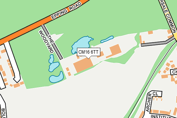
CM16 6TT is located in the Epping Lindsey and Thornwood Common electoral ward, within the local authority district of Epping Forest and the English Parliamentary constituency of Epping Forest. The Sub Integrated Care Board (ICB) Location is NHS Hertfordshire and West Essex ICB - 07H and the police force is Essex. This postcode has been in use since April 1986.


GetTheData
Source: OS OpenMap – Local (Ordnance Survey)
Source: OS VectorMap District (Ordnance Survey)
Licence: Open Government Licence (requires attribution)
| Easting | 547286 |
| Northing | 202993 |
| Latitude | 51.706354 |
| Longitude | 0.130204 |
GetTheData
Source: Open Postcode Geo
Licence: Open Government Licence
| Country | England |
| Postcode District | CM16 |
| ➜ CM16 open data dashboard ➜ See where CM16 is on a map | |
GetTheData
Source: Land Registry Price Paid Data
Licence: Open Government Licence
Elevation or altitude of CM16 6TT as distance above sea level:
| Metres | Feet | |
|---|---|---|
| Elevation | 100m | 328ft |
Elevation is measured from the approximate centre of the postcode, to the nearest point on an OS contour line from OS Terrain 50, which has contour spacing of ten vertical metres.
➜ How high above sea level am I? Find the elevation of your current position using your device's GPS.
GetTheData
Source: Open Postcode Elevation
Licence: Open Government Licence
| Ward | Epping Lindsey And Thornwood Common |
| Constituency | Epping Forest |
GetTheData
Source: ONS Postcode Database
Licence: Open Government Licence
| June 2022 | Public order | On or near Boleyn Row | 328m |
| June 2022 | Public order | On or near Garnon Mead | 379m |
| June 2022 | Violence and sexual offences | On or near Coopersale Common | 412m |
| ➜ Get more crime data in our Crime section | |||
GetTheData
Source: data.police.uk
Licence: Open Government Licence
| Coopersale Turning (Epping Road) | Coopersale | 348m |
| Piazza (Coopersale Common) | Coopersale | 410m |
| Piazza (Coopersale Common) | Coopersale | 414m |
| Coopersale Turning (Epping Road) | Coopersale | 424m |
| St. Margaret's Hospital - Main Rd (The Plain) | Epping | 532m |
| Epping Underground Station | Epping | 1,809m |
GetTheData
Source: NaPTAN
Licence: Open Government Licence
GetTheData
Source: ONS Postcode Database
Licence: Open Government Licence


➜ Get more ratings from the Food Standards Agency
GetTheData
Source: Food Standards Agency
Licence: FSA terms & conditions
| Last Collection | |||
|---|---|---|---|
| Location | Mon-Fri | Sat | Distance |
| Theydon Oak | 16:25 | 09:00 | 1,211m |
| High Street | 17:30 | 11:30 | 1,312m |
| Epping P.o. High Street | 18:15 | 12:30 | 1,356m |
GetTheData
Source: Dracos
Licence: Creative Commons Attribution-ShareAlike
| Facility | Distance |
|---|---|
| Coopersale Cricket Club Brickfield Road, Coopersale, Epping Grass Pitches | 589m |
| Stonards Hill Recreation Ground Stonards Hill, Epping Grass Pitches, Outdoor Tennis Courts | 756m |
| Frampton Road Recreation Ground Frampton Road, Epping Grass Pitches | 1.1km |
GetTheData
Source: Active Places
Licence: Open Government Licence
| School | Phase of Education | Distance |
|---|---|---|
| Coopersale and Theydon Garnon Church of England Voluntary Controlled Primary School Brickfield Road, Coopersale Common, Epping, CM16 7QX | Primary | 529m |
| Open Box Education Centre St John's Road, Epping, Essex, Essex, CM16 5DN | Not applicable | 1.6km |
| Epping Primary School Coronation Hill, Epping, CM16 5DU | Primary | 1.8km |
GetTheData
Source: Edubase
Licence: Open Government Licence
The below table lists the International Territorial Level (ITL) codes (formerly Nomenclature of Territorial Units for Statistics (NUTS) codes) and Local Administrative Units (LAU) codes for CM16 6TT:
| ITL 1 Code | Name |
|---|---|
| TLH | East |
| ITL 2 Code | Name |
| TLH3 | Essex |
| ITL 3 Code | Name |
| TLH35 | West Essex |
| LAU 1 Code | Name |
| E07000072 | Epping Forest |
GetTheData
Source: ONS Postcode Directory
Licence: Open Government Licence
The below table lists the Census Output Area (OA), Lower Layer Super Output Area (LSOA), and Middle Layer Super Output Area (MSOA) for CM16 6TT:
| Code | Name | |
|---|---|---|
| OA | E00170076 | |
| LSOA | E01021761 | Epping Forest 005B |
| MSOA | E02004531 | Epping Forest 005 |
GetTheData
Source: ONS Postcode Directory
Licence: Open Government Licence
| CM16 6TW | The Plain | 245m |
| CM16 7RA | Laburnum Road | 291m |
| CM16 6TP | The Lodge | 292m |
| CM16 7RL | Chevely Close | 303m |
| CM16 7QR | Coopersale Common | 311m |
| CM16 7QY | Institute Road | 330m |
| CM16 7QS | Coopersale Common | 345m |
| CM16 6FE | Seymour Chase | 352m |
| CM16 6FH | King Henrys Walk | 366m |
| CM16 6FF | Boleyn Row | 367m |
GetTheData
Source: Open Postcode Geo; Land Registry Price Paid Data
Licence: Open Government Licence