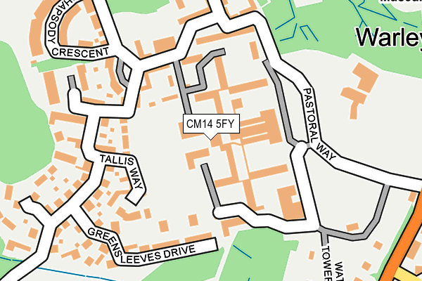
CM14 5FY lies on The Galleries in Warley, Brentwood. CM14 5FY is located in the Warley electoral ward, within the local authority district of Brentwood and the English Parliamentary constituency of Brentwood and Ongar. The Sub Integrated Care Board (ICB) Location is NHS Mid and South Essex ICB - 99E and the police force is Essex. This postcode has been in use since September 2013.


GetTheData
Source: OS OpenMap – Local (Ordnance Survey)
Source: OS VectorMap District (Ordnance Survey)
Licence: Open Government Licence (requires attribution)
| Easting | 558848 |
| Northing | 192313 |
| Latitude | 51.607249 |
| Longitude | 0.292520 |
GetTheData
Source: Open Postcode Geo
Licence: Open Government Licence
| Street | The Galleries |
| Locality | Warley |
| Town/City | Brentwood |
| Country | England |
| Postcode District | CM14 |
| ➜ CM14 open data dashboard ➜ See where CM14 is on a map ➜ Where is Brentwood? | |
GetTheData
Source: Land Registry Price Paid Data
Licence: Open Government Licence
Elevation or altitude of CM14 5FY as distance above sea level:
| Metres | Feet | |
|---|---|---|
| Elevation | 90m | 295ft |
Elevation is measured from the approximate centre of the postcode, to the nearest point on an OS contour line from OS Terrain 50, which has contour spacing of ten vertical metres.
➜ How high above sea level am I? Find the elevation of your current position using your device's GPS.
GetTheData
Source: Open Postcode Elevation
Licence: Open Government Licence
| Ward | Warley |
| Constituency | Brentwood And Ongar |
GetTheData
Source: ONS Postcode Database
Licence: Open Government Licence
| December 2023 | Violence and sexual offences | On or near Tallis Way | 121m |
| November 2023 | Other theft | On or near Tallis Way | 121m |
| November 2023 | Vehicle crime | On or near Hanover Place | 266m |
| ➜ Get more crime data in our Crime section | |||
GetTheData
Source: data.police.uk
Licence: Open Government Licence
| Medical Centre (Pastoral Way) | Warley | 150m |
| Osborne Heights (Pastoral Way) | Warley | 151m |
| Warley Hill (Pastoral Way) | Warley | 201m |
| Rhapsody Crescent (Vaughan Williams Way) | Warley | 266m |
| Albert Street (Warley Hill) | Warley | 323m |
| Brentwood Station | 0.9km |
| Shenfield Station | 3.7km |
| Harold Wood Station | 4.4km |
GetTheData
Source: NaPTAN
Licence: Open Government Licence
| Percentage of properties with Next Generation Access | 100.0% |
| Percentage of properties with Superfast Broadband | 100.0% |
| Percentage of properties with Ultrafast Broadband | 0.0% |
| Percentage of properties with Full Fibre Broadband | 0.0% |
Superfast Broadband is between 30Mbps and 300Mbps
Ultrafast Broadband is > 300Mbps
| Percentage of properties unable to receive 2Mbps | 0.0% |
| Percentage of properties unable to receive 5Mbps | 0.0% |
| Percentage of properties unable to receive 10Mbps | 0.0% |
| Percentage of properties unable to receive 30Mbps | 0.0% |
GetTheData
Source: Ofcom
Licence: Ofcom Terms of Use (requires attribution)
GetTheData
Source: ONS Postcode Database
Licence: Open Government Licence


➜ Get more ratings from the Food Standards Agency
GetTheData
Source: Food Standards Agency
Licence: FSA terms & conditions
| Last Collection | |||
|---|---|---|---|
| Location | Mon-Fri | Sat | Distance |
| Warley Common, | 17:10 | 12:00 | 361m |
| Crescent Road | 17:20 | 11:30 | 536m |
| Hampden Crescent | 17:30 | 09:25 | 575m |
GetTheData
Source: Dracos
Licence: Creative Commons Attribution-ShareAlike
| Facility | Distance |
|---|---|
| Clements Park Pastoral Way, Warley, Brentwood Grass Pitches | 235m |
| Everlast Fitness Club (Brentwood) (Closed) Chindits Lane, Warley, Brentwood Health and Fitness Gym, Swimming Pool, Studio, Squash Courts | 525m |
| Warley Playing Fields The Drive, Great Warley, Brentwood Grass Pitches | 669m |
GetTheData
Source: Active Places
Licence: Open Government Licence
| School | Phase of Education | Distance |
|---|---|---|
| Holly Trees Primary School Vaughan Williams Way, Warley, Brentwood, CM14 5RY | Primary | 420m |
| Warley Primary School Chindits Lane, Warley, Brentwood, CM14 5LF | Primary | 612m |
| Ursuline Preparatory School Great Ropers Lane,, Brentwood, Essex, Brentwood, CM13 3HR | Not applicable | 828m |
GetTheData
Source: Edubase
Licence: Open Government Licence
The below table lists the International Territorial Level (ITL) codes (formerly Nomenclature of Territorial Units for Statistics (NUTS) codes) and Local Administrative Units (LAU) codes for CM14 5FY:
| ITL 1 Code | Name |
|---|---|
| TLH | East |
| ITL 2 Code | Name |
| TLH3 | Essex |
| ITL 3 Code | Name |
| TLH36 | Heart of Essex |
| LAU 1 Code | Name |
| E07000068 | Brentwood |
GetTheData
Source: ONS Postcode Directory
Licence: Open Government Licence
The below table lists the Census Output Area (OA), Lower Layer Super Output Area (LSOA), and Middle Layer Super Output Area (MSOA) for CM14 5FY:
| Code | Name | |
|---|---|---|
| OA | E00109092 | |
| LSOA | E01021472 | Brentwood 008C |
| MSOA | E02004471 | Brentwood 008 |
GetTheData
Source: ONS Postcode Directory
Licence: Open Government Licence
| CM14 5GL | The Galleries | 30m |
| CM14 5GJ | The Galleries | 33m |
| CM14 5FR | The Galleries | 41m |
| CM14 5FS | The Galleries | 49m |
| CM14 5GF | The Galleries | 71m |
| CM14 5FF | The Galleries | 87m |
| CM14 5FN | The Galleries | 93m |
| CM14 5GH | The Galleries | 95m |
| CM14 5FW | The Galleries | 97m |
| CM14 5GN | The Galleries | 119m |
GetTheData
Source: Open Postcode Geo; Land Registry Price Paid Data
Licence: Open Government Licence