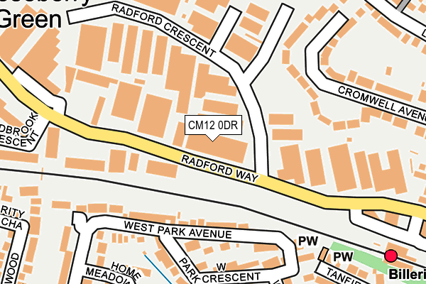
CM12 0DR is located in the Billericay West electoral ward, within the local authority district of Basildon and the English Parliamentary constituency of Basildon and Billericay. The Sub Integrated Care Board (ICB) Location is NHS Mid and South Essex ICB - 99E and the police force is Essex. This postcode has been in use since December 1996.


GetTheData
Source: OS OpenMap – Local (Ordnance Survey)
Source: OS VectorMap District (Ordnance Survey)
Licence: Open Government Licence (requires attribution)
| Easting | 567220 |
| Northing | 195152 |
| Latitude | 51.630331 |
| Longitude | 0.414661 |
GetTheData
Source: Open Postcode Geo
Licence: Open Government Licence
| Country | England |
| Postcode District | CM12 |
| ➜ CM12 open data dashboard ➜ See where CM12 is on a map ➜ Where is Billericay? | |
GetTheData
Source: Land Registry Price Paid Data
Licence: Open Government Licence
Elevation or altitude of CM12 0DR as distance above sea level:
| Metres | Feet | |
|---|---|---|
| Elevation | 70m | 230ft |
Elevation is measured from the approximate centre of the postcode, to the nearest point on an OS contour line from OS Terrain 50, which has contour spacing of ten vertical metres.
➜ How high above sea level am I? Find the elevation of your current position using your device's GPS.
GetTheData
Source: Open Postcode Elevation
Licence: Open Government Licence
| Ward | Billericay West |
| Constituency | Basildon And Billericay |
GetTheData
Source: ONS Postcode Database
Licence: Open Government Licence
| January 2024 | Violence and sexual offences | On or near Radford Court | 331m |
| January 2024 | Other theft | On or near Tanfield Drive | 331m |
| January 2024 | Violence and sexual offences | On or near Tanfield Drive | 331m |
| ➜ Get more crime data in our Crime section | |||
GetTheData
Source: data.police.uk
Licence: Open Government Licence
| Railway Station (Station Approach) | Billericay | 239m |
| Railway Station (Station Approach) | Billericay | 249m |
| Railway Station (Station Approach) | Billericay | 263m |
| Gooseberry Green (Radford Way) | Billericay | 268m |
| Railway Station (Station Approach) | Billericay | 270m |
| Billericay Station | 0.3km |
| Ingatestone Station | 4.6km |
GetTheData
Source: NaPTAN
Licence: Open Government Licence
GetTheData
Source: ONS Postcode Database
Licence: Open Government Licence


➜ Get more ratings from the Food Standards Agency
GetTheData
Source: Food Standards Agency
Licence: FSA terms & conditions
| Last Collection | |||
|---|---|---|---|
| Location | Mon-Fri | Sat | Distance |
| Radford Way | 17:30 | 77m | |
| Billericay Station | 17:30 | 11:00 | 285m |
| Western Road | 17:30 | 12:00 | 399m |
GetTheData
Source: Dracos
Licence: Creative Commons Attribution-ShareAlike
| Facility | Distance |
|---|---|
| Puregym (Billericay) Radford Way, Billericay Swimming Pool, Health and Fitness Gym, Studio | 118m |
| Studio 360 Fitness Radford Way, Billericay Health and Fitness Gym, Studio | 144m |
| Players Lounge Radford Way, Radford Way, Billericay Artificial Grass Pitch | 161m |
GetTheData
Source: Active Places
Licence: Open Government Licence
| School | Phase of Education | Distance |
|---|---|---|
| St John's School 47-49 Stock Road, Billericay, Essex, CM12 0AR | Not applicable | 662m |
| Buttsbury Infant School Perry Street, Billericay, CM12 0NX | Primary | 1km |
| Brightside Primary School Brightside, Billericay, CM12 0LE | Primary | 1.1km |
GetTheData
Source: Edubase
Licence: Open Government Licence
The below table lists the International Territorial Level (ITL) codes (formerly Nomenclature of Territorial Units for Statistics (NUTS) codes) and Local Administrative Units (LAU) codes for CM12 0DR:
| ITL 1 Code | Name |
|---|---|
| TLH | East |
| ITL 2 Code | Name |
| TLH3 | Essex |
| ITL 3 Code | Name |
| TLH37 | Essex Thames Gateway |
| LAU 1 Code | Name |
| E07000066 | Basildon |
GetTheData
Source: ONS Postcode Directory
Licence: Open Government Licence
The below table lists the Census Output Area (OA), Lower Layer Super Output Area (LSOA), and Middle Layer Super Output Area (MSOA) for CM12 0DR:
| Code | Name | |
|---|---|---|
| OA | E00107932 | |
| LSOA | E01021247 | Basildon 003E |
| MSOA | E02004426 | Basildon 003 |
GetTheData
Source: ONS Postcode Directory
Licence: Open Government Licence
| CM12 0DX | Radford Way | 36m |
| CM12 0DZ | Station Court | 113m |
| CM12 9EE | West Park Avenue | 123m |
| CM12 9EG | West Park Crescent | 175m |
| CM12 0DT | Bebington Close | 178m |
| CM12 9EF | West Park Avenue | 185m |
| CM12 9EQ | West Park Crescent | 192m |
| CM12 0AG | Cromwell Avenue | 199m |
| CM12 9ED | West Park Crescent | 235m |
| CM12 9HQ | Home Meadows | 256m |
GetTheData
Source: Open Postcode Geo; Land Registry Price Paid Data
Licence: Open Government Licence