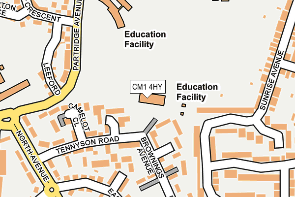
CM1 4HY is located in the Patching Hall electoral ward, within the local authority district of Chelmsford and the English Parliamentary constituency of Chelmsford. The Sub Integrated Care Board (ICB) Location is NHS Mid and South Essex ICB - 06Q and the police force is Essex. This postcode has been in use since December 2013.


GetTheData
Source: OS OpenMap – Local (Ordnance Survey)
Source: OS VectorMap District (Ordnance Survey)
Licence: Open Government Licence (requires attribution)
| Easting | 569960 |
| Northing | 208512 |
| Latitude | 51.749522 |
| Longitude | 0.460712 |
GetTheData
Source: Open Postcode Geo
Licence: Open Government Licence
| Country | England |
| Postcode District | CM1 |
| ➜ CM1 open data dashboard ➜ See where CM1 is on a map ➜ Where is Chelmsford? | |
GetTheData
Source: Land Registry Price Paid Data
Licence: Open Government Licence
Elevation or altitude of CM1 4HY as distance above sea level:
| Metres | Feet | |
|---|---|---|
| Elevation | 40m | 131ft |
Elevation is measured from the approximate centre of the postcode, to the nearest point on an OS contour line from OS Terrain 50, which has contour spacing of ten vertical metres.
➜ How high above sea level am I? Find the elevation of your current position using your device's GPS.
GetTheData
Source: Open Postcode Elevation
Licence: Open Government Licence
| Ward | Patching Hall |
| Constituency | Chelmsford |
GetTheData
Source: ONS Postcode Database
Licence: Open Government Licence
| December 2023 | Anti-social behaviour | On or near Town Croft | 370m |
| October 2023 | Vehicle crime | On or near Chestnut Walk | 276m |
| September 2023 | Vehicle crime | On or near Chestnut Walk | 276m |
| ➜ Get more crime data in our Crime section | |||
GetTheData
Source: data.police.uk
Licence: Open Government Licence
| Tennyson Road (North Avenue) | Chelmsford | 248m |
| Sunrise Avenue | Chelmsford | 254m |
| Sunrise Avenue | Chelmsford | 258m |
| North Avenue | Chelmsford | 310m |
| North Avenue | Chelmsford | 328m |
| Chelmsford Station | 1.6km |
GetTheData
Source: NaPTAN
Licence: Open Government Licence
GetTheData
Source: ONS Postcode Database
Licence: Open Government Licence


➜ Get more ratings from the Food Standards Agency
GetTheData
Source: Food Standards Agency
Licence: FSA terms & conditions
| Last Collection | |||
|---|---|---|---|
| Location | Mon-Fri | Sat | Distance |
| Sunrise Avenue | 17:30 | 11:45 | 360m |
| Broomfield Parade P.o. | 17:30 | 12:00 | 609m |
| Fell Christy | 17:30 | 12:20 | 899m |
GetTheData
Source: Dracos
Licence: Creative Commons Attribution-ShareAlike
| Facility | Distance |
|---|---|
| St Pius X Catholic Primary School Tennyson Road, Chelmsford Grass Pitches | 0m |
| St John Payne Catholic School Patching Hall Lane, Chelmsford Grass Pitches, Health and Fitness Gym, Sports Hall | 249m |
| Parkwood Academy Melbourne Avenue, Chelmsford Grass Pitches | 306m |
GetTheData
Source: Active Places
Licence: Open Government Licence
| School | Phase of Education | Distance |
|---|---|---|
| St Pius X Catholic Primary School Tennyson Road, Chelmsford, CM1 4HY | Primary | 17m |
| St John Payne Catholic School, Chelmsford Patching Hall Lane, Chelmsford, CM1 4BS | Secondary | 305m |
| Tanglewood Nursery School Melbourne Avenue, Chelmsford, CM1 2DX | Nursery | 307m |
GetTheData
Source: Edubase
Licence: Open Government Licence
The below table lists the International Territorial Level (ITL) codes (formerly Nomenclature of Territorial Units for Statistics (NUTS) codes) and Local Administrative Units (LAU) codes for CM1 4HY:
| ITL 1 Code | Name |
|---|---|
| TLH | East |
| ITL 2 Code | Name |
| TLH3 | Essex |
| ITL 3 Code | Name |
| TLH36 | Heart of Essex |
| LAU 1 Code | Name |
| E07000070 | Chelmsford |
GetTheData
Source: ONS Postcode Directory
Licence: Open Government Licence
The below table lists the Census Output Area (OA), Lower Layer Super Output Area (LSOA), and Middle Layer Super Output Area (MSOA) for CM1 4HY:
| Code | Name | |
|---|---|---|
| OA | E00109665 | |
| LSOA | E01021589 | Chelmsford 006C |
| MSOA | E02004490 | Chelmsford 006 |
GetTheData
Source: ONS Postcode Directory
Licence: Open Government Licence
| CM1 4HX | Brownings Avenue | 133m |
| CM1 4HZ | Tennyson Road | 160m |
| CM1 4NF | Camelot Close | 162m |
| CM1 4NE | Arthur Court | 162m |
| CM1 4JJ | Eastern Crescent | 176m |
| CM1 4WT | Leeford | 214m |
| CM1 4JN | Sunrise Avenue | 222m |
| CM1 4JH | Eastern Crescent | 226m |
| CM1 4JP | Sunrise Avenue | 226m |
| CM1 4JG | Partridge Avenue | 232m |
GetTheData
Source: Open Postcode Geo; Land Registry Price Paid Data
Licence: Open Government Licence