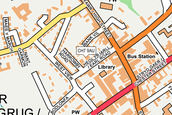
CH7 9AU is located in the Mold: Broncoed electoral ward, within the unitary authority of Flintshire and the Welsh Parliamentary constituency of Delyn. The Local Health Board is Betsi Cadwaladr University and the police force is North Wales. This postcode has been in use since February 2021.


GetTheData
Source: OS OpenMap – Local (Ordnance Survey)
Source: OS VectorMap District (Ordnance Survey)
Licence: Open Government Licence (requires attribution)
| Easting | 323621 |
| Northing | 363987 |
| Latitude | 53.167513 |
| Longitude | -3.143980 |
GetTheData
Source: Open Postcode Geo
Licence: Open Government Licence
| Country | Wales |
| Postcode District | CH7 |
| ➜ CH7 open data dashboard ➜ See where CH7 is on a map ➜ Where is Mold? | |
GetTheData
Source: Land Registry Price Paid Data
Licence: Open Government Licence
Elevation or altitude of CH7 9AU as distance above sea level:
| Metres | Feet | |
|---|---|---|
| Elevation | 120m | 394ft |
Elevation is measured from the approximate centre of the postcode, to the nearest point on an OS contour line from OS Terrain 50, which has contour spacing of ten vertical metres.
➜ How high above sea level am I? Find the elevation of your current position using your device's GPS.
GetTheData
Source: Open Postcode Elevation
Licence: Open Government Licence
| Ward | Mold: Broncoed |
| Constituency | Delyn |
GetTheData
Source: ONS Postcode Database
Licence: Open Government Licence
| January 2024 | Anti-social behaviour | On or near Parking Area | 95m |
| January 2024 | Violence and sexual offences | On or near Parking Area | 95m |
| January 2024 | Criminal damage and arson | On or near Parking Area | 273m |
| ➜ Get more crime data in our Crime section | |||
GetTheData
Source: data.police.uk
Licence: Open Government Licence
| Town Hall (Earl Road) | Mold | 55m |
| Bethesda (New Street) | Mold | 166m |
| Bethesda (New Street) | Mold | 183m |
| Red Lion Inn (Wrexham Street) | Mold | 244m |
| Maes Y March (Clayton Road) | Mold | 250m |
GetTheData
Source: NaPTAN
Licence: Open Government Licence
GetTheData
Source: ONS Postcode Database
Licence: Open Government Licence


➜ Get more ratings from the Food Standards Agency
GetTheData
Source: Food Standards Agency
Licence: FSA terms & conditions
| Last Collection | |||
|---|---|---|---|
| Location | Mon-Fri | Sat | Distance |
| Mold Main Post Office | 18:00 | 13:00 | 28m |
| High Street | 17:30 | 11:30 | 127m |
| Chester Street | 17:20 | 11:30 | 253m |
GetTheData
Source: Dracos
Licence: Creative Commons Attribution-ShareAlike
| School | Phase of Education | Distance |
|---|---|---|
| Ysgol Glanrafon Lon Bryn Coch, Yr Wyddgrug, Sir Y Fflint, CH7 1PS | Not applicable | 347m |
| Ysgol Bryn Coch C.P. Victoria Road, Mold, Flintshire, CH7 1EW | Not applicable | 356m |
| Ysgol Bryn Gwalia C.P. Clayton Road, Mold, Flintshire, CH7 1SU | Not applicable | 469m |
GetTheData
Source: Edubase
Licence: Open Government Licence
The below table lists the International Territorial Level (ITL) codes (formerly Nomenclature of Territorial Units for Statistics (NUTS) codes) and Local Administrative Units (LAU) codes for CH7 9AU:
| ITL 1 Code | Name |
|---|---|
| TLL | Wales |
| ITL 2 Code | Name |
| TLL2 | East Wales |
| ITL 3 Code | Name |
| TLL23 | Flintshire and Wrexham |
| LAU 1 Code | Name |
| W06000005 | Flintshire |
GetTheData
Source: ONS Postcode Directory
Licence: Open Government Licence
The below table lists the Census Output Area (OA), Lower Layer Super Output Area (LSOA), and Middle Layer Super Output Area (MSOA) for CH7 9AU:
| Code | Name | |
|---|---|---|
| OA | W00001691 | |
| LSOA | W01000314 | Flintshire 016B |
| MSOA | W02000073 | Flintshire 016 |
GetTheData
Source: ONS Postcode Directory
Licence: Open Government Licence
| CH7 1AX | Earl Road | 34m |
| CH7 1BN | Bank Villas | 67m |
| CH7 1DN | Harrowby Road | 69m |
| CH7 1DW | West View | 79m |
| CH7 1DP | Sycamore Villas | 83m |
| CH7 1DS | Cambrian Villas | 124m |
| CH7 1SP | Bryn Garmon | 128m |
| CH7 1AZ | High Street | 129m |
| CH7 1BH | High Street | 132m |
| CH7 1BQ | High Street | 133m |
GetTheData
Source: Open Postcode Geo; Land Registry Price Paid Data
Licence: Open Government Licence