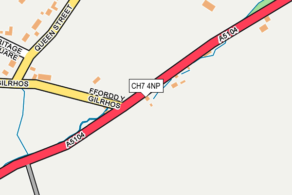
CH7 4NP is located in the Treuddyn electoral ward, within the unitary authority of Flintshire and the Welsh Parliamentary constituency of Alyn and Deeside. The Local Health Board is Betsi Cadwaladr University and the police force is North Wales. This postcode has been in use since January 1980.


GetTheData
Source: OS OpenMap – Local (Ordnance Survey)
Source: OS VectorMap District (Ordnance Survey)
Licence: Open Government Licence (requires attribution)
| Easting | 325121 |
| Northing | 357630 |
| Latitude | 53.110579 |
| Longitude | -3.120059 |
GetTheData
Source: Open Postcode Geo
Licence: Open Government Licence
| Country | Wales |
| Postcode District | CH7 |
| ➜ CH7 open data dashboard ➜ See where CH7 is on a map ➜ Where is Treuddyn? | |
GetTheData
Source: Land Registry Price Paid Data
Licence: Open Government Licence
Elevation or altitude of CH7 4NP as distance above sea level:
| Metres | Feet | |
|---|---|---|
| Elevation | 230m | 755ft |
Elevation is measured from the approximate centre of the postcode, to the nearest point on an OS contour line from OS Terrain 50, which has contour spacing of ten vertical metres.
➜ How high above sea level am I? Find the elevation of your current position using your device's GPS.
GetTheData
Source: Open Postcode Elevation
Licence: Open Government Licence
| Ward | Treuddyn |
| Constituency | Alyn And Deeside |
GetTheData
Source: ONS Postcode Database
Licence: Open Government Licence
| December 2023 | Bicycle theft | On or near Parking Area | 476m |
| October 2023 | Violence and sexual offences | On or near Parking Area | 476m |
| January 2023 | Public order | On or near Cae Mynach | 432m |
| ➜ Get more crime data in our Crime section | |||
GetTheData
Source: data.police.uk
Licence: Open Government Licence
| Farmers Arms (Ffordd-y-llan) | Treuddyn | 441m |
| Farmers Arms (Ffordd-y-llan) | Treuddyn | 446m |
| Berea Chapel (Ffordd-y-llan) | Treuddyn | 456m |
| Berea Chapel (Ffordd-y-llan) | Treuddyn | 462m |
| Queen Street (Ffordd-y-llan) | Treuddyn | 531m |
| Penyffordd Station | 5.7km |
GetTheData
Source: NaPTAN
Licence: Open Government Licence
| Percentage of properties with Next Generation Access | 100.0% |
| Percentage of properties with Superfast Broadband | 100.0% |
| Percentage of properties with Ultrafast Broadband | 0.0% |
| Percentage of properties with Full Fibre Broadband | 0.0% |
Superfast Broadband is between 30Mbps and 300Mbps
Ultrafast Broadband is > 300Mbps
| Percentage of properties unable to receive 2Mbps | 0.0% |
| Percentage of properties unable to receive 5Mbps | 0.0% |
| Percentage of properties unable to receive 10Mbps | 0.0% |
| Percentage of properties unable to receive 30Mbps | 0.0% |
GetTheData
Source: Ofcom
Licence: Ofcom Terms of Use (requires attribution)
GetTheData
Source: ONS Postcode Database
Licence: Open Government Licence


➜ Get more ratings from the Food Standards Agency
GetTheData
Source: Food Standards Agency
Licence: FSA terms & conditions
| Last Collection | |||
|---|---|---|---|
| Location | Mon-Fri | Sat | Distance |
| Treuddyn Post Office | 15:45 | 10:45 | 468m |
| Penystryt | 15:31 | 10:30 | 575m |
| Ffordd Top Y Rhos | 15:32 | 10:30 | 1,016m |
GetTheData
Source: Dracos
Licence: Creative Commons Attribution-ShareAlike
| School | Phase of Education | Distance |
|---|---|---|
| Ysgol Terrig Ffordd Y Llan, Treuddyn, Yr Wyddgrug, Sir Y Fflint, CH7 4LN | Not applicable | 378m |
| Ysgol Parc Y Llan Ffordd Y Llan, Treuddyn, Mold, Flintshire, CH7 4LN | Not applicable | 378m |
| Ysgol Y Rhos Ffordd Y Blaenau, Treuddyn, CH7 4NS | Not applicable | 2.6km |
GetTheData
Source: Edubase
Licence: Open Government Licence
The below table lists the International Territorial Level (ITL) codes (formerly Nomenclature of Territorial Units for Statistics (NUTS) codes) and Local Administrative Units (LAU) codes for CH7 4NP:
| ITL 1 Code | Name |
|---|---|
| TLL | Wales |
| ITL 2 Code | Name |
| TLL2 | East Wales |
| ITL 3 Code | Name |
| TLL23 | Flintshire and Wrexham |
| LAU 1 Code | Name |
| W06000005 | Flintshire |
GetTheData
Source: ONS Postcode Directory
Licence: Open Government Licence
The below table lists the Census Output Area (OA), Lower Layer Super Output Area (LSOA), and Middle Layer Super Output Area (MSOA) for CH7 4NP:
| Code | Name | |
|---|---|---|
| OA | W00001822 | |
| LSOA | W01000339 | Flintshire 019D |
| MSOA | W02000076 | Flintshire 019 |
GetTheData
Source: ONS Postcode Directory
Licence: Open Government Licence
| CH7 4LE | Ffordd Corwen | 86m |
| CH7 4LX | Green Park | 336m |
| CH7 4PD | Heritage Square | 356m |
| CH7 4LU | Queen Street | 366m |
| CH7 4LW | Erw Ffynnon | 370m |
| CH7 4NW | Ffordd Y Gilrhos | 395m |
| CH7 4JN | Cae Mynach | 417m |
| CH7 4LY | Maes Glas | 425m |
| CH7 4NF | Rhos Helyg | 445m |
| CH7 4NX | Bryn Yr Ysgol | 448m |
GetTheData
Source: Open Postcode Geo; Land Registry Price Paid Data
Licence: Open Government Licence