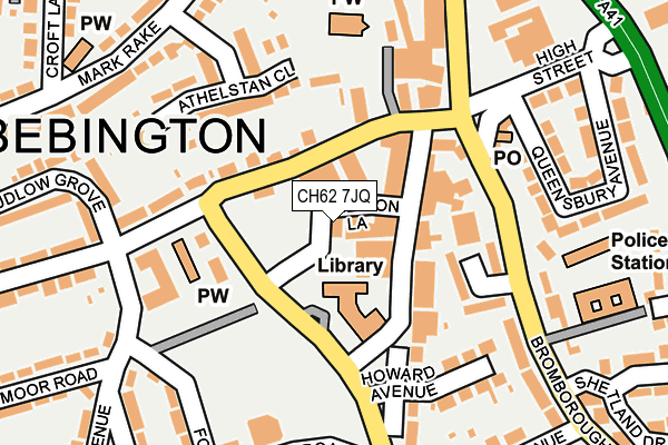
CH62 7JQ is located in the Bromborough electoral ward, within the metropolitan district of Wirral and the English Parliamentary constituency of Wirral South. The Sub Integrated Care Board (ICB) Location is NHS Cheshire and Merseyside ICB - 12F and the police force is Merseyside. This postcode has been in use since June 1999.


GetTheData
Source: OS OpenMap – Local (Ordnance Survey)
Source: OS VectorMap District (Ordnance Survey)
Licence: Open Government Licence (requires attribution)
| Easting | 334902 |
| Northing | 382045 |
| Latitude | 53.331295 |
| Longitude | -2.978960 |
GetTheData
Source: Open Postcode Geo
Licence: Open Government Licence
| Country | England |
| Postcode District | CH62 |
| ➜ CH62 open data dashboard ➜ See where CH62 is on a map ➜ Where is Bebington? | |
GetTheData
Source: Land Registry Price Paid Data
Licence: Open Government Licence
Elevation or altitude of CH62 7JQ as distance above sea level:
| Metres | Feet | |
|---|---|---|
| Elevation | 30m | 98ft |
Elevation is measured from the approximate centre of the postcode, to the nearest point on an OS contour line from OS Terrain 50, which has contour spacing of ten vertical metres.
➜ How high above sea level am I? Find the elevation of your current position using your device's GPS.
GetTheData
Source: Open Postcode Elevation
Licence: Open Government Licence
| Ward | Bromborough |
| Constituency | Wirral South |
GetTheData
Source: ONS Postcode Database
Licence: Open Government Licence
| January 2024 | Violence and sexual offences | On or near Parking Area | 57m |
| January 2024 | Shoplifting | On or near Parking Area | 57m |
| December 2023 | Drugs | On or near Parking Area | 57m |
| ➜ Get more crime data in our Crime section | |||
GetTheData
Source: data.police.uk
Licence: Open Government Licence
| Bromborough Library (Allport Lane) | Bromborough | 61m |
| Bromborough Cross (The Rake) | Bromborough | 79m |
| Bromborough Cross (Allport Lane) | Bromborough | 93m |
| Bromborough Cross (Bromborough Village Road) | Bromborough | 148m |
| Bromborough Cross (Bromborough Village Road) | Bromborough | 160m |
| Bromborough Rake Station | 0.7km |
| Bromborough Station | 1.2km |
| Spital Station | 1.4km |
GetTheData
Source: NaPTAN
Licence: Open Government Licence
GetTheData
Source: ONS Postcode Database
Licence: Open Government Licence


➜ Get more ratings from the Food Standards Agency
GetTheData
Source: Food Standards Agency
Licence: FSA terms & conditions
| Last Collection | |||
|---|---|---|---|
| Location | Mon-Fri | Sat | Distance |
| Bromborough Post Office, | 18:30 | 12:00 | 162m |
| Central Avenue | 17:15 | 12:00 | 645m |
| Croft Industrial Estate. | 18:25 | 876m | |
GetTheData
Source: Dracos
Licence: Creative Commons Attribution-ShareAlike
| Facility | Distance |
|---|---|
| Jd Gyms (Bromborough) Old Hall Road, Wirral Health and Fitness Gym | 429m |
| Mendell Primary School Allport Lane, Bromborough, Wirral Grass Pitches | 506m |
| Bromborough Recreation Ground The Rake, Bromborough Grass Pitches | 532m |
GetTheData
Source: Active Places
Licence: Open Government Licence
| School | Phase of Education | Distance |
|---|---|---|
| Mendell Primary School Allport Lane, Bromborough, Wirral, CH62 7HN | Primary | 487m |
| Co-op Academy Woodslee Croft Avenue, Bromborough, Wirral, CH62 2BP | Primary | 577m |
| Christ The King Catholic Primary School Allport Road, Bromborough, Wirral, CH62 6AE | Primary | 769m |
GetTheData
Source: Edubase
Licence: Open Government Licence
The below table lists the International Territorial Level (ITL) codes (formerly Nomenclature of Territorial Units for Statistics (NUTS) codes) and Local Administrative Units (LAU) codes for CH62 7JQ:
| ITL 1 Code | Name |
|---|---|
| TLD | North West (England) |
| ITL 2 Code | Name |
| TLD7 | Merseyside |
| ITL 3 Code | Name |
| TLD74 | Wirral |
| LAU 1 Code | Name |
| E08000015 | Wirral |
GetTheData
Source: ONS Postcode Directory
Licence: Open Government Licence
The below table lists the Census Output Area (OA), Lower Layer Super Output Area (LSOA), and Middle Layer Super Output Area (MSOA) for CH62 7JQ:
| Code | Name | |
|---|---|---|
| OA | E00036165 | |
| LSOA | E01007137 | Wirral 039C |
| MSOA | E02001505 | Wirral 039 |
GetTheData
Source: ONS Postcode Directory
Licence: Open Government Licence
| CH62 7HP | Allport Lane Precinct | 69m |
| CH62 7AE | The Rake | 74m |
| CH62 7HH | Allport Lane Precinct | 85m |
| CH62 7BF | Allport Lane | 112m |
| CH62 7EU | Bromborough Village Road | 120m |
| CH62 7JT | Parkwood Close | 123m |
| CH62 7AQ | The Rake | 127m |
| CH62 2EX | Athelstan Close | 168m |
| CH62 7ET | Bromborough Village Road | 168m |
| CH62 7HA | High Street | 182m |
GetTheData
Source: Open Postcode Geo; Land Registry Price Paid Data
Licence: Open Government Licence