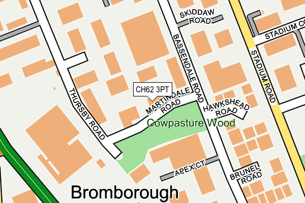
CH62 3PT is located in the Bromborough electoral ward, within the metropolitan district of Wirral and the English Parliamentary constituency of Wirral South. The Sub Integrated Care Board (ICB) Location is NHS Cheshire and Merseyside ICB - 12F and the police force is Merseyside. This postcode has been in use since June 2003.


GetTheData
Source: OS OpenMap – Local (Ordnance Survey)
Source: OS VectorMap District (Ordnance Survey)
Licence: Open Government Licence (requires attribution)
| Easting | 335314 |
| Northing | 382476 |
| Latitude | 53.335219 |
| Longitude | -2.972862 |
GetTheData
Source: Open Postcode Geo
Licence: Open Government Licence
| Country | England |
| Postcode District | CH62 |
| ➜ CH62 open data dashboard ➜ See where CH62 is on a map ➜ Where is Bebington? | |
GetTheData
Source: Land Registry Price Paid Data
Licence: Open Government Licence
Elevation or altitude of CH62 3PT as distance above sea level:
| Metres | Feet | |
|---|---|---|
| Elevation | 30m | 98ft |
Elevation is measured from the approximate centre of the postcode, to the nearest point on an OS contour line from OS Terrain 50, which has contour spacing of ten vertical metres.
➜ How high above sea level am I? Find the elevation of your current position using your device's GPS.
GetTheData
Source: Open Postcode Elevation
Licence: Open Government Licence
| Ward | Bromborough |
| Constituency | Wirral South |
GetTheData
Source: ONS Postcode Database
Licence: Open Government Licence
| June 2022 | Other theft | On or near Stadium Court | 313m |
| June 2022 | Anti-social behaviour | On or near Stadium Court | 313m |
| June 2022 | Anti-social behaviour | On or near Stadium Court | 313m |
| ➜ Get more crime data in our Crime section | |||
GetTheData
Source: data.police.uk
Licence: Open Government Licence
| Plantation Road (Stadium Road) | Bromborough | 268m |
| Plantation Road (Stadium Road) | Bromborough | 269m |
| Stanhope Drive (Spital Road) | Bromborough | 342m |
| Stanhope Drive (Spital Road) | Bromborough | 360m |
| Hardknott Road (Old Hall Road) | Bromborough | 398m |
| Bromborough Rake Station | 1.3km |
| Spital Station | 1.5km |
| Bromborough Station | 1.8km |
GetTheData
Source: NaPTAN
Licence: Open Government Licence
Estimated total energy consumption in CH62 3PT by fuel type, 2015.
| Consumption (kWh) | 206,140 |
|---|---|
| Meter count | 9 |
| Mean (kWh/meter) | 22,904 |
| Median (kWh/meter) | 19,693 |
GetTheData
Source: Postcode level gas estimates: 2015 (experimental)
Source: Postcode level electricity estimates: 2015 (experimental)
Licence: Open Government Licence
GetTheData
Source: ONS Postcode Database
Licence: Open Government Licence


➜ Get more ratings from the Food Standards Agency
GetTheData
Source: Food Standards Agency
Licence: FSA terms & conditions
| Last Collection | |||
|---|---|---|---|
| Location | Mon-Fri | Sat | Distance |
| Croft Industrial Estate. | 18:25 | 341m | |
| Bromborough Post Office, | 18:30 | 12:00 | 445m |
| Asda Bromborough, | 17:00 | 12:00 | 551m |
GetTheData
Source: Dracos
Licence: Creative Commons Attribution-ShareAlike
| Facility | Distance |
|---|---|
| Jd Gyms (Bromborough) Old Hall Road, Wirral Health and Fitness Gym | 533m |
| Puregym (Bromborough) Welton Road, Bromborough, Wirral Health and Fitness Gym, Studio | 539m |
| Co-op Academy Woodslee Croft Avenue, Wirral Grass Pitches | 695m |
GetTheData
Source: Active Places
Licence: Open Government Licence
| School | Phase of Education | Distance |
|---|---|---|
| Co-op Academy Woodslee Croft Avenue, Bromborough, Wirral, CH62 2BP | Primary | 695m |
| Mendell Primary School Allport Lane, Bromborough, Wirral, CH62 7HN | Primary | 963m |
| Christ The King Catholic Primary School Allport Road, Bromborough, Wirral, CH62 6AE | Primary | 1.1km |
GetTheData
Source: Edubase
Licence: Open Government Licence
The below table lists the International Territorial Level (ITL) codes (formerly Nomenclature of Territorial Units for Statistics (NUTS) codes) and Local Administrative Units (LAU) codes for CH62 3PT:
| ITL 1 Code | Name |
|---|---|
| TLD | North West (England) |
| ITL 2 Code | Name |
| TLD7 | Merseyside |
| ITL 3 Code | Name |
| TLD74 | Wirral |
| LAU 1 Code | Name |
| E08000015 | Wirral |
GetTheData
Source: ONS Postcode Directory
Licence: Open Government Licence
The below table lists the Census Output Area (OA), Lower Layer Super Output Area (LSOA), and Middle Layer Super Output Area (MSOA) for CH62 3PT:
| Code | Name | |
|---|---|---|
| OA | E00036166 | |
| LSOA | E01007135 | Wirral 039A |
| MSOA | E02001505 | Wirral 039 |
GetTheData
Source: ONS Postcode Directory
Licence: Open Government Licence
| CH62 3PL | Caldbeck Road | 302m |
| CH62 3NX | Old Hall Road | 328m |
| CH62 7ES | Bromborough Village Road | 371m |
| CH62 7HB | Queensbury Avenue | 410m |
| CH62 7HA | High Street | 422m |
| CH62 7ET | Bromborough Village Road | 431m |
| CH62 3PQ | Welton Road | 431m |
| CH62 2DN | Mark Rake | 440m |
| CH62 2BB | New Chester Road | 457m |
| CH62 2AQ | Spital Road | 459m |
GetTheData
Source: Open Postcode Geo; Land Registry Price Paid Data
Licence: Open Government Licence