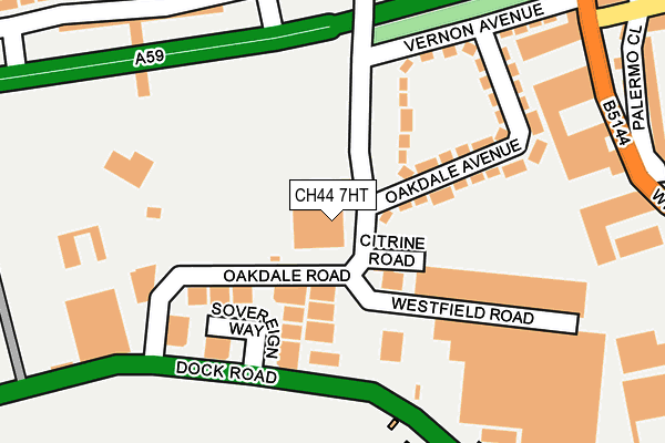
CH44 7HT is located in the Seacombe electoral ward, within the metropolitan district of Wirral and the English Parliamentary constituency of Wallasey. The Sub Integrated Care Board (ICB) Location is NHS Cheshire and Merseyside ICB - 12F and the police force is Merseyside. This postcode has been in use since June 1999.


GetTheData
Source: OS OpenMap – Local (Ordnance Survey)
Source: OS VectorMap District (Ordnance Survey)
Licence: Open Government Licence (requires attribution)
| Easting | 331638 |
| Northing | 390536 |
| Latitude | 53.407210 |
| Longitude | -3.029801 |
GetTheData
Source: Open Postcode Geo
Licence: Open Government Licence
| Country | England |
| Postcode District | CH44 |
| ➜ CH44 open data dashboard ➜ See where CH44 is on a map ➜ Where is Wallasey? | |
GetTheData
Source: Land Registry Price Paid Data
Licence: Open Government Licence
Elevation or altitude of CH44 7HT as distance above sea level:
| Metres | Feet | |
|---|---|---|
| Elevation | 10m | 33ft |
Elevation is measured from the approximate centre of the postcode, to the nearest point on an OS contour line from OS Terrain 50, which has contour spacing of ten vertical metres.
➜ How high above sea level am I? Find the elevation of your current position using your device's GPS.
GetTheData
Source: Open Postcode Elevation
Licence: Open Government Licence
| Ward | Seacombe |
| Constituency | Wallasey |
GetTheData
Source: ONS Postcode Database
Licence: Open Government Licence
| December 2023 | Drugs | On or near Parry Street | 359m |
| November 2023 | Drugs | On or near Parry Street | 359m |
| November 2023 | Anti-social behaviour | On or near Parry Street | 359m |
| ➜ Get more crime data in our Crime section | |||
GetTheData
Source: data.police.uk
Licence: Open Government Licence
| Oakdale Road (Dock Road) | Poulton | 136m |
| Oakdale Road (Dock Road) | Oakdale | 140m |
| East Float (Dock Road) | Oakdale | 281m |
| St Paul's Road (Wheatland Lane) | Seacombe | 324m |
| Gorsey Lane (Dock Road) | Poulton | 347m |
| Birkenhead Park Station | 1.3km |
| Conway Park Station | 1.6km |
| Birkenhead Hamilton Square Station | 1.8km |
GetTheData
Source: NaPTAN
Licence: Open Government Licence
GetTheData
Source: ONS Postcode Database
Licence: Open Government Licence


➜ Get more ratings from the Food Standards Agency
GetTheData
Source: Food Standards Agency
Licence: FSA terms & conditions
| Last Collection | |||
|---|---|---|---|
| Location | Mon-Fri | Sat | Distance |
| Seacombe View | 17:33 | 12:00 | 460m |
| Ashville Road | 17:15 | 12:00 | 1,607m |
| Conway Street | 17:15 | 12:00 | 1,626m |
GetTheData
Source: Dracos
Licence: Creative Commons Attribution-ShareAlike
| Facility | Distance |
|---|---|
| Rycroft Playing Fields Rycroft Road, Poulton Grass Pitches | 362m |
| St Josephs Primary School Wheatland Lane, Wallasey Sports Hall, Grass Pitches | 504m |
| The Soccer Dome Wallasey Birkenhead Road, Wallasey Artificial Grass Pitch | 643m |
GetTheData
Source: Active Places
Licence: Open Government Licence
| School | Phase of Education | Distance |
|---|---|---|
| Kingsway Primary School Ashville Road, Wallasey, CH44 9EF | Primary | 348m |
| Somerville Nursery School Brentwood Street, Wallasey, CH44 4BB | Nursery | 514m |
| St Joseph's Catholic Primary School, Wallasey Wheatland Lane, Wallasey, CH44 7ED | Primary | 543m |
GetTheData
Source: Edubase
Licence: Open Government Licence
The below table lists the International Territorial Level (ITL) codes (formerly Nomenclature of Territorial Units for Statistics (NUTS) codes) and Local Administrative Units (LAU) codes for CH44 7HT:
| ITL 1 Code | Name |
|---|---|
| TLD | North West (England) |
| ITL 2 Code | Name |
| TLD7 | Merseyside |
| ITL 3 Code | Name |
| TLD74 | Wirral |
| LAU 1 Code | Name |
| E08000015 | Wirral |
GetTheData
Source: ONS Postcode Directory
Licence: Open Government Licence
The below table lists the Census Output Area (OA), Lower Layer Super Output Area (LSOA), and Middle Layer Super Output Area (MSOA) for CH44 7HT:
| Code | Name | |
|---|---|---|
| OA | E00168413 | |
| LSOA | E01007269 | Wirral 010C |
| MSOA | E02001476 | Wirral 010 |
GetTheData
Source: ONS Postcode Directory
Licence: Open Government Licence
| CH41 1DL | Sovereign Way | 88m |
| CH44 7HS | Oakdale Road | 114m |
| CH44 7EU | Oakdale Avenue | 131m |
| CH41 1HW | Ocean Park | 202m |
| CH44 7ET | Oakdale Avenue | 219m |
| CH41 1DP | Dock Road | 241m |
| CH44 7ES | Vernon Avenue | 243m |
| CH44 7ER | Wheatland Business Park | 250m |
| CH44 4AJ | Gorsedale Road | 253m |
| CH41 1DN | Dock Road | 275m |
GetTheData
Source: Open Postcode Geo; Land Registry Price Paid Data
Licence: Open Government Licence