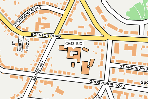
CH43 1UQ is located in the Claughton electoral ward, within the metropolitan district of Wirral and the English Parliamentary constituency of Birkenhead. The Sub Integrated Care Board (ICB) Location is NHS Cheshire and Merseyside ICB - 12F and the police force is Merseyside. This postcode has been in use since June 1999.


GetTheData
Source: OS OpenMap – Local (Ordnance Survey)
Source: OS VectorMap District (Ordnance Survey)
Licence: Open Government Licence (requires attribution)
| Easting | 330386 |
| Northing | 388636 |
| Latitude | 53.389953 |
| Longitude | -3.048212 |
GetTheData
Source: Open Postcode Geo
Licence: Open Government Licence
| Country | England |
| Postcode District | CH43 |
| ➜ CH43 open data dashboard ➜ See where CH43 is on a map ➜ Where is Birkenhead? | |
GetTheData
Source: Land Registry Price Paid Data
Licence: Open Government Licence
Elevation or altitude of CH43 1UQ as distance above sea level:
| Metres | Feet | |
|---|---|---|
| Elevation | 30m | 98ft |
Elevation is measured from the approximate centre of the postcode, to the nearest point on an OS contour line from OS Terrain 50, which has contour spacing of ten vertical metres.
➜ How high above sea level am I? Find the elevation of your current position using your device's GPS.
GetTheData
Source: Open Postcode Elevation
Licence: Open Government Licence
| Ward | Claughton |
| Constituency | Birkenhead |
GetTheData
Source: ONS Postcode Database
Licence: Open Government Licence
| October 2023 | Violence and sexual offences | On or near The Nook | 444m |
| October 2023 | Violence and sexual offences | On or near The Nook | 444m |
| October 2023 | Other theft | On or near Parking Area | 460m |
| ➜ Get more crime data in our Crime section | |||
GetTheData
Source: data.police.uk
Licence: Open Government Licence
| Epworth Close (Egerton Road) | Claughton | 47m |
| St Anselms College (Egerton Road) | Claughton | 66m |
| Manor Hill (Egerton Road) | Claughton | 120m |
| Egerton Road (Park Road West) | Birkenhead Park | 140m |
| Park Drive (Park Road South) | Birkenhead Park | 203m |
| Birkenhead Park Station | 1km |
| Birkenhead North Station | 1.7km |
| Conway Park Station | 1.7km |
GetTheData
Source: NaPTAN
Licence: Open Government Licence
GetTheData
Source: ONS Postcode Database
Licence: Open Government Licence


➜ Get more ratings from the Food Standards Agency
GetTheData
Source: Food Standards Agency
Licence: FSA terms & conditions
| Last Collection | |||
|---|---|---|---|
| Location | Mon-Fri | Sat | Distance |
| Alton Road | 17:30 | 12:00 | 628m |
| Ashville Road | 17:15 | 12:00 | 669m |
| Beresford Road | 17:00 | 12:00 | 1,195m |
GetTheData
Source: Dracos
Licence: Creative Commons Attribution-ShareAlike
| Facility | Distance |
|---|---|
| St Anselms College Manor Hill, Prenton Health and Fitness Gym, Sports Hall | 0m |
| Birkenhead High School Academy Devonshire Place, Prenton Sports Hall, Swimming Pool | 308m |
| Birkenhead Park Cricket Club Park Drive, Prenton Grass Pitches | 368m |
GetTheData
Source: Active Places
Licence: Open Government Licence
| School | Phase of Education | Distance |
|---|---|---|
| St Anselm's College Manor Hill, Prenton, CH43 1UQ | Secondary | 44m |
| Birkenhead High School Academy 86 Devonshire Place, Prenton, CH43 1TY | All-through | 268m |
| Birkenhead Park School Park Road South, Birkenhead, CH43 4UY | Secondary | 375m |
GetTheData
Source: Edubase
Licence: Open Government Licence
The below table lists the International Territorial Level (ITL) codes (formerly Nomenclature of Territorial Units for Statistics (NUTS) codes) and Local Administrative Units (LAU) codes for CH43 1UQ:
| ITL 1 Code | Name |
|---|---|
| TLD | North West (England) |
| ITL 2 Code | Name |
| TLD7 | Merseyside |
| ITL 3 Code | Name |
| TLD74 | Wirral |
| LAU 1 Code | Name |
| E08000015 | Wirral |
GetTheData
Source: ONS Postcode Directory
Licence: Open Government Licence
The below table lists the Census Output Area (OA), Lower Layer Super Output Area (LSOA), and Middle Layer Super Output Area (MSOA) for CH43 1UQ:
| Code | Name | |
|---|---|---|
| OA | E00036290 | |
| LSOA | E01007156 | Wirral 015B |
| MSOA | E02001481 | Wirral 015 |
GetTheData
Source: ONS Postcode Directory
Licence: Open Government Licence
| CH43 1UL | Egerton Road | 79m |
| CH43 1UB | Grosvenor Road | 102m |
| CH43 1TE | Palm Grove | 127m |
| CH43 1UG | Manor Hill | 150m |
| CH43 1UE | Manor Hill | 171m |
| CH43 1UR | Park Road West | 174m |
| CH43 1UF | Manor Hill | 201m |
| CH43 1UW | St Vincent Road | 211m |
| CH43 1UP | St Seiriol Grove | 239m |
| CH43 1UN | St Vincent Road | 239m |
GetTheData
Source: Open Postcode Geo; Land Registry Price Paid Data
Licence: Open Government Licence