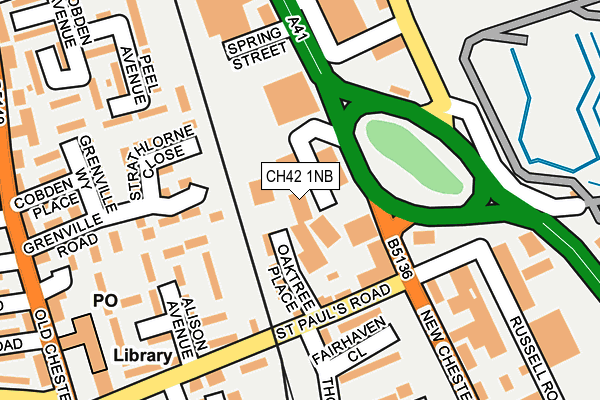
CH42 1NB is located in the Rock Ferry electoral ward, within the metropolitan district of Wirral and the English Parliamentary constituency of Birkenhead. The Sub Integrated Care Board (ICB) Location is NHS Cheshire and Merseyside ICB - 12F and the police force is Merseyside. This postcode has been in use since December 1999.


GetTheData
Source: OS OpenMap – Local (Ordnance Survey)
Source: OS VectorMap District (Ordnance Survey)
Licence: Open Government Licence (requires attribution)
| Easting | 332797 |
| Northing | 387140 |
| Latitude | 53.376821 |
| Longitude | -3.011647 |
GetTheData
Source: Open Postcode Geo
Licence: Open Government Licence
| Country | England |
| Postcode District | CH42 |
| ➜ CH42 open data dashboard ➜ See where CH42 is on a map ➜ Where is Birkenhead? | |
GetTheData
Source: Land Registry Price Paid Data
Licence: Open Government Licence
Elevation or altitude of CH42 1NB as distance above sea level:
| Metres | Feet | |
|---|---|---|
| Elevation | 10m | 33ft |
Elevation is measured from the approximate centre of the postcode, to the nearest point on an OS contour line from OS Terrain 50, which has contour spacing of ten vertical metres.
➜ How high above sea level am I? Find the elevation of your current position using your device's GPS.
GetTheData
Source: Open Postcode Elevation
Licence: Open Government Licence
| Ward | Rock Ferry |
| Constituency | Birkenhead |
GetTheData
Source: ONS Postcode Database
Licence: Open Government Licence
| January 2024 | Other theft | On or near Eldon Road | 457m |
| January 2024 | Violence and sexual offences | On or near Eldon Road | 457m |
| December 2023 | Criminal damage and arson | On or near St Paul'S Close | 443m |
| ➜ Get more crime data in our Crime section | |||
GetTheData
Source: data.police.uk
Licence: Open Government Licence
| St Pauls Road (New Chester Road) | Rock Ferry | 168m |
| Union Street (New Chester Road) | Tranmere | 207m |
| Woburn Place (New Chester Road) | Rock Ferry | 253m |
| Crofton Road (Old Chester Road) | Tranmere | 293m |
| Southwick Road (Old Chester Road) | Mersey Park | 297m |
| Rock Ferry Station | 0.5km |
| Green Lane Station | 0.8km |
| Birkenhead Central Station | 1.4km |
GetTheData
Source: NaPTAN
Licence: Open Government Licence
Estimated total energy consumption in CH42 1NB by fuel type, 2015.
| Consumption (kWh) | 107,548 |
|---|---|
| Meter count | 6 |
| Mean (kWh/meter) | 17,925 |
| Median (kWh/meter) | 15,920 |
GetTheData
Source: Postcode level gas estimates: 2015 (experimental)
Source: Postcode level electricity estimates: 2015 (experimental)
Licence: Open Government Licence
GetTheData
Source: ONS Postcode Database
Licence: Open Government Licence


➜ Get more ratings from the Food Standards Agency
GetTheData
Source: Food Standards Agency
Licence: FSA terms & conditions
| Last Collection | |||
|---|---|---|---|
| Location | Mon-Fri | Sat | Distance |
| Woodchurch Lane | 18:05 | 1,581m | |
| Garrick Snug | 17:30 | 12:00 | 1,728m |
| New Ferry Road | 17:30 | 12:00 | 1,821m |
GetTheData
Source: Dracos
Licence: Creative Commons Attribution-ShareAlike
| Facility | Distance |
|---|---|
| Rock Ferry Primary School Sports Hall Ionic Street, Rock Ferry Sports Hall | 342m |
| Byrne Avenue Baths Byrne Avenue, Birkenhead Sports Hall, Swimming Pool | 739m |
| Victoria Park (Birkenhead) Bebington Road, Birkenhead Grass Pitches | 789m |
GetTheData
Source: Active Places
Licence: Open Government Licence
| School | Phase of Education | Distance |
|---|---|---|
| Rock Ferry Primary School Ionic Street, Rock Ferry, Birkenhead, CH42 2BL | Primary | 326m |
| Well Lane Primary School Park Road, Tranmere, Birkenhead, CH42 5PF | Primary | 510m |
| Mersey Park Primary School Elm Road, Higher Tranmere, Wirral, CH42 0PH | Primary | 840m |
GetTheData
Source: Edubase
Licence: Open Government Licence
The below table lists the International Territorial Level (ITL) codes (formerly Nomenclature of Territorial Units for Statistics (NUTS) codes) and Local Administrative Units (LAU) codes for CH42 1NB:
| ITL 1 Code | Name |
|---|---|
| TLD | North West (England) |
| ITL 2 Code | Name |
| TLD7 | Merseyside |
| ITL 3 Code | Name |
| TLD74 | Wirral |
| LAU 1 Code | Name |
| E08000015 | Wirral |
GetTheData
Source: ONS Postcode Directory
Licence: Open Government Licence
The below table lists the Census Output Area (OA), Lower Layer Super Output Area (LSOA), and Middle Layer Super Output Area (MSOA) for CH42 1NB:
| Code | Name | |
|---|---|---|
| OA | E00168419 | |
| LSOA | E01007295 | Wirral 027D |
| MSOA | E02001493 | Wirral 027 |
GetTheData
Source: ONS Postcode Directory
Licence: Open Government Licence
| CH42 1LG | St Pauls Road | 104m |
| CH42 3YP | Alison Avenue | 169m |
| CH42 3UY | St Pauls Road | 183m |
| CH42 1LB | New Chester Road | 212m |
| CH42 3UP | 215m | |
| CH42 3YQ | Peel Avenue | 225m |
| CH42 1RP | Russell Road | 245m |
| CH41 9HP | Campbeltown Road | 252m |
| CH42 3TD | Old Chester Road | 266m |
| CH42 3UR | 276m |
GetTheData
Source: Open Postcode Geo; Land Registry Price Paid Data
Licence: Open Government Licence